Iowa weather: Rounds of rain and storms likely this week
DES MOINES, Iowa —
Showers and storms will taper off this evening, but clouds will linger keeping temperatures cool. Another round of storms is likely by Monday morning before warmer air surges in ahead of additional storm chances Monday night with heavy rain potential throughout the week ahead.
Interactive Radar | Weather Alerts | Skycams
Scattered rain showers and occasional thunderstorms lingered across central and southern Iowa this afternoon, helping to keep temperatures in the 50s and low 60s making it one of the coolest days we have seen in months. Northern Iowa was a little drier with temperatures warming into the upper 60s.
Showers will fade away this evening, but the cloud cover will likely linger helping to keep temperatures on the cool side. Lows tonight will not dip too far from the current temperatures, falling into the mid-50s for most of the area.
Warmer and more humid air will begin to surge back into Iowa early Monday kicking off storms in southwest Iowa near sunrise. Those storms will quickly move across central Iowa early in the morning, bringing some quick downpours along with plenty of lightning and thunder. This round of rain should be ending by mid-morning with breezy and warm conditions in the afternoon.
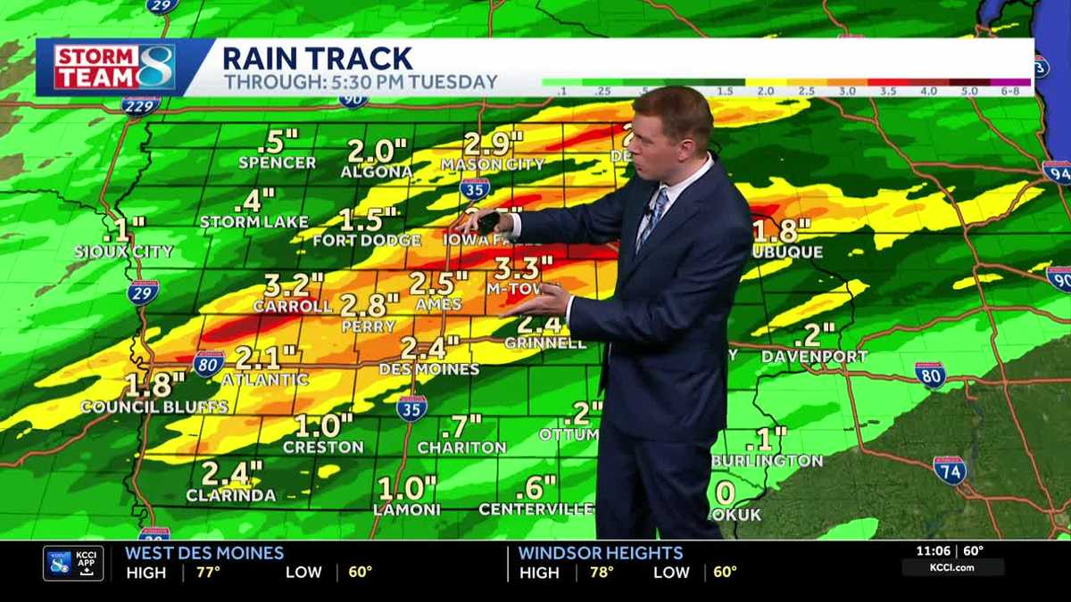
Highs will reach toward 80 degrees as the humidity increases, setting the stage for additional storms to develop in western Iowa by the early evening. A few strong storms with high winds and hail will be possible initially, but that severe risk quickly diminishes with the main risk for the late evening and overnight being heavy rain. The line of storms is expected to move slowly through central Iowa, prolonging that heavy rain and leading to several inches of rainfall.
Some isolated flash flooding will be possible Monday night into Tuesday, particularly if heavy rain falls on areas impacted by last week’s heavy rain event. Creeks and rivers will need to be monitored as well with significant runoff still working through the state.
Showers should taper off Tuesday morning, but another round of storms is likely late Tuesday night or early Wednesday with on and off rain and storms possible on Wednesday. The heavy rain risk will return with this round of storms. The rain tapers again for Thursday before another chance enters the forecast Friday evening into Saturday morning. All told, a wide area of 3 to 5 inches of rainfall is possible across central Iowa through the week, with smaller pockets of heavier rain possible.
High temperatures for most of the week will generally be in the low to mid-70s thanks to the clouds and rain chances, with some upper 70s possible by Thursday or Friday.
Keep an eye on weather across Iowa with KCCI’s skycams
Weather watchers can keep an eye on conditions by checking our skycam page, which shows aerial views from more than 25 sites across the state.
Iowa weather forecast
Tonight: Partly to mostly cloudy. Temperatures steady in the upper 50s. Scattered storms arrive by sunrise. Low 58F. Winds E at 10 to 15 mph.
Tomorrow: Showers and thundershowers in the morning, then windy late with skies turning partly cloudy. Storms redevelop in the evening. High near 80F. Winds SE at 20 to 30 mph.
Tomorrow Night: Thunderstorms likely in the evening. Potential for a few strong storms, heavy rainfall possible. Low 64F. Winds SSW at 15 to 25 mph.
Tuesday: Showers in the morning, then variable clouds during the afternoon with still a chance of showers. High 72F. Winds NNW at 5 to 10 mph.