A CHILLY & WINDY day under partly/mostly sunny skies across Nebraska! More sunshine & lighter winds farther west will result in warmer temperatures.
North winds will gust to near 25–35+ mph across much of E Nebraska Friday! Winds relax by this evening as high pressure sinks in!
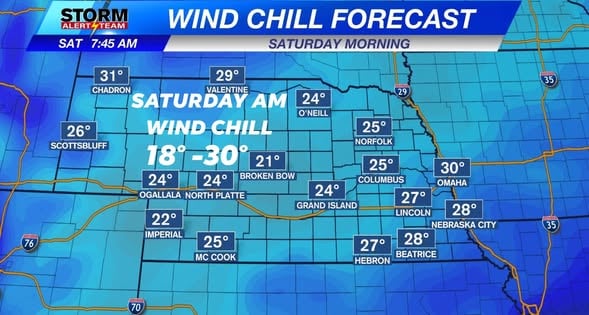
Saturday morning, temperatures from 27° – 32° & Wind chills near 22° – 30° across SE Nebraska.
Statewide low temperatures Saturday will range from 26° – 35°, with the NW seeing the warmer air.
WIND CHILL temperatures Saturday morning will feel like the 20s across the state!
The FREEZE WATCH is in effect through 9am Saturday. Temperatures will drop near or below freezing for much of us early Saturday.
SW winds will gust to near 25-30+ mph Saturday morning giving us that wind chill factor! By the afternoon, the winds help us warm up.
High temperatures look to range from 62° – 78° through the next 10 days! *Morning temperatures look to range from 28° – 54°! WINDY, BLUSTERY & FREEZING temperatures with FROST Saturday morning. This weekend into next week looks breezy, but like Fall with above average temperatures. Next rain/storm chance will come next Thursday-Saturday.
Meteorologist Houston Hall
Facebook: HHallWX
YouTube: HHallWX
Tags: Beatrice, blustery, channel 8 weather, channel-8-eyewitness-news-weather, cool, Fall, fall freeze, first frost, forecast, Grand Island, hail, Hastings, High winds, lincoln, McCook, Nebraska, North Platte, Omaha, rain, weather, Wind