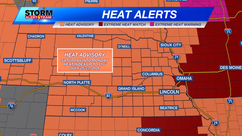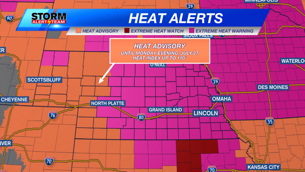
High heat and humidity continue through the rest of the weekend and into early next week. Some of the state remains under a Heat Advisory (orange) until 10 p.m. CDT on Monday, July 27. Feels-like temperatures could reach up to 110° in these areas.
Widespread heat indices in the triple digits are expected for Sunday afternoon.
Additionally, central and eastern Nebraska (along with Sioux and Dawes Counties in the panhandle) will be under an Extreme Heat Warning (magenta) from 12 p.m. to 9 p.m. Sunday, July 26 for southeast Nebraska, and until 7 a.m. Monday, July 27 for northern Nebraska. Prolonged feels-like temperatures will close in on 115° for Sunday afternoon and evening. We will see little relief overnight, with lows in the mid to upper 70s.
Northern Nebraska may escape heat indices above 100° on Monday, though the rest of us may not be so lucky.
-
Severe Weather Threat – July 25, 2026
-
Severe Weather Threat – July 26, 2026
-
Severe Weather Threat – July 27, 202
Lost in all of the extreme heat talk is the potential for severe weather across the state. Isolated to scattered severe storms remain possible over the next several days, with large hail and damaging winds being the main concerns in the strongest storms.
Above is the latest run of StormCast, showing storm timing from Saturday afternoon to early Monday. Not everyone will see storms over the coming days, but those who do could see strong to severe storms.
Overnight lows will be warm for most of the state as temperatures attempt to stay in the 70s by early Sunday morning.
Warm and humid conditions in Lincoln for any outdoor plans on Saturday night. Expect a muggy start to our day on Sunday morning as well.
Sunday afternoon features highs statewide from the upper 90s to close to 110° in far portions of the panhandle. Thanks to a strong southerly wind, one could skip using the hair dryer; the same results could be achieved by simply stepping outside.
Heat, humidity and strong winds highlight the forecast for the end of the weekend in the Capital City. Be sure to drink plenty of water and give yourself several breaks from the heat if you plan to spend extended time outdoors.
Finally, that brings us to the extended forecast. After a passing “cold” front on Monday, we return to highs in the mid-90s. Periodic storm chances arrive throughout the back half of next week, with temperatures closer to average by the start of August.
Storm Alert Team Meteorologist
Dominic Ferraro
X: DomFerraroWX
Facebook: DomFerraroWX
YouTube: DomFerraroWX
Categories: Channel 8 Eyewitness News Weather, Forecast
Tags: Aurora, Beatrice, extreme heat warning, forecast, Grand Island, Hastings, heat advisory, hot and humid, Kearney, lincoln, McCook, severe weather threat, seward, weather