Iowa weather: Cooler air moves into central Iowa
Intense heat this afternoon will turn to scattered strong storms this evening, some storms could be severe in central and eastern Iowa.
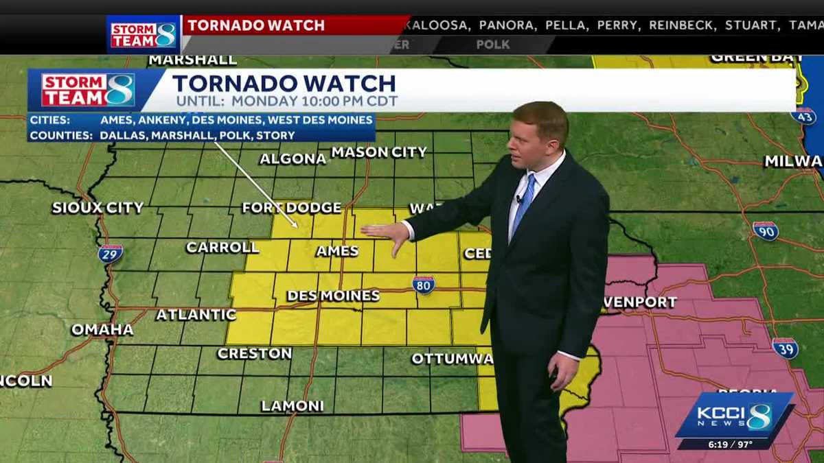
Right, well, we know our storm teammate has been all over what’s been happening severe weather wise across our state today. Let’s get back out to David. David, hopefully you had *** chance to catch your breath *** little bit because it was 2 hours nonstop for you guys. Yes, yes, it was pretty busy and we still have *** couple of pretty strong storms out there right now. In fact, *** new severe thunderstorm warning for the Ames area down toward Huxley because of this storm. Look at that. Impressive picture right now. This is from the DOT camera at Highway 30, the flyover from northbound I-35. So we are looking to the north northwest. This is *** shelf cloud coming into Ames right now and some interesting color right there. Some high winds likely with this storm as it comes into the Ames area and perhaps. Some half dollar sized hail as well, but I think the main risk with this storm is going to be the high winds as this surges in. So you can see that shelf cloud, some low hanging clouds right there. That’s the strong winds surging out ahead of this storm and it will likely come with some torrential rainfall as well. I want to check *** couple of the other views here. This is I-35 just north of Ames was hoping to see some of the sky, but here on Highway 30 here just west of University Avenue in Ames, the trees are certainly blown. You can see those dark clouds coming on in. And just to the east of I-35 on Highway 30 as well, watching those darker clouds as they roll their way in. So this is the cluster of storms now that we are watching. We had one round of storms that developed north of Algona raced off to the east, east of Marshalltown that continues to dive south here. I had one powerful storm that rolled through Hamilton and Astory counties with some. Baseball sized tail. Now we’re watching *** new storm that is working its way into northern Story County right here, and that is the storm that we were just looking at severe thunderstorm warning here for Story County. This goes until 7 o’clock. High winds, the main risk and perhaps some ping pong ball sized hail as well with this storm as it continues to drop southward at around 30 miles an hour. Also have *** severe thunderstorm warning here for this storm just southwest of Marshalltown. This goes until 7 o’clock as well. Some hail and gusty winds with that storm, but really the strongest storm right now just moved through Story City once again right over Gilbert moving into Ames as we speak, and wind is likely the biggest threat with this. You can see some of these bright greens and yellows right there. That is potentially some pretty strong winds, you know, we’re talking wind speeds maybe up to 70-75 MPH. That is, you know, *** few 100 ft 2000 ft up in the air, so it may not. Be making it all the way to the ground, but certainly some 60 mph winds are not out of the question with this storm as it moves south into Ames. So that’s going to bring it into Ames here in about the next 5 to 10 minutes already affecting the north side of town, and that will continue to raise southward. We’ll have to watch this storm as it is going to be making its way potentially into southeastern Story County and maybe into parts of Polk and Jasper County here over the next hour. All of this area also under. Tornado watch until 10 o’clock here tonight that will likely be canceled before 10 o’clock, but certainly some storms making their way in, and it will bring some relief from the heat. 97 degrees still here in Des Moines, but look at Ames, 77 because of that storm coming through. 97 in Grams, 96 in Norwalk. So there’s the cooler air already taking shape now with those storms, 75 in Iowa Falls. The heat index here in town 106, so still baking when you step outside. So this line continues to drop southward. It should be moving into the metro. Uh, over the next hour, hour and *** half, and then it’ll drop our temperatures down to the 60s and 70s here tonight. Tomorrow, look at this 84, *** little breezy. That north wind will be strong, 79 on Wednesday. Nice little break from the heat, but the higher temperatures do build back in by the time we get to the weekend.
Iowa weather: Cooler air moves into central Iowa
Intense heat this afternoon will turn to scattered strong storms this evening, some storms could be severe in central and eastern Iowa.
Updated: 10:48 PM CDT Jul 20, 2026
Editorial Standards ⓘ
Cooler air pushes in behind the front with gusty north winds on Tuesday. Highs only top out in the low to mid-80s, with some 70s possible in northern Iowa. Interactive Radar | Weather Alerts | SkycamsMuch of the area could see highs in the upper 70s on Wednesday. The mild air continues Thursday and Friday with highs near 80.Rain chances are lower through the end of the week, with only a slight chance of showers Thursday into Friday. High pressure builds back in for the weekend with more sunshine and hotter conditions returning.Keep an eye on weather across Iowa with KCCI’s skycamsWeather watchers can keep an eye on conditions by checking our skycam page, which shows aerial views from more than 20 sites across the state.Iowa weather forecast:Today: Generally sunny despite a few afternoon clouds. Isolated pop-up storms possible in the afternoon. Any storm will be very brief. High 93F. Winds SW at 10 to 15 mph.Tonight: Clear skies. Low near 74F. Winds SW at 10 to 15 mph.Tomorrow: Generally sunny despite a few afternoon clouds. High 93F. Winds NW at 5 to 10 mph.Tomorrow Night: A few clouds. Low around 70F. Winds ENE at 5 to 10 mph.
DES MOINES, Iowa —
Cooler air pushes in behind the front with gusty north winds on Tuesday. Highs only top out in the low to mid-80s, with some 70s possible in northern Iowa.
Interactive Radar | Weather Alerts | Skycams
Much of the area could see highs in the upper 70s on Wednesday. The mild air continues Thursday and Friday with highs near 80.
Rain chances are lower through the end of the week, with only a slight chance of showers Thursday into Friday. High pressure builds back in for the weekend with more sunshine and hotter conditions returning.
Keep an eye on weather across Iowa with KCCI’s skycams
Weather watchers can keep an eye on conditions by checking our skycam page, which shows aerial views from more than 20 sites across the state.
2 of 29
Des Moines: Iowa State Fairgrounds
3 of 29
Des Moines: Northeast mixmaster
4 of 29
Des Moines: Principal Park
5 of 29
Algona: Security State Bank
6 of 29
Altoona: Prairie Meadows Casino, Racetrack & Hotel
7 of 29
Ames: Flyover ramp
8 of 29
Ankeny: The District
9 of 29
Arnolds Park Amusement Park: West Lake Okoboji
10 of 29
Downtown Atlantic
11 of 29
Bettendorf: Iowa-Illinois Memorial Bridge
12 of 29
Boone: Scenic Valley Railroad
13 of 29
Boone: Seven Oaks Recreation
15 of 29
Council Bluffs: Bayliss Park
16 of 29
Council Bluffs: Lewis and Clark Monument Park
17 of 29
Creston Greater Regional Health
18 of 29
Indianola: Simpson College
19 of 29
Iowa City: University of Iowa Stanley Hydraulics Laboratory
PHOTO: University of Iowa
20 of 29
Lamoni: Amish Country Store
21 of 29
Malcom: Interstate 80
22 of 29
Marshalltown: Westown Apartments
23 of 29
Newton: DMACC Legacy Plaza
24 of 29
Osceola: Interstate 35/Highway 34 overpass
25 of 29
Panora: Lake Panorama
26 of 29
Pella: The Amsterdam Hotel
27 of 29
Polk City: Big Creek Marina
28 of 29
West Des Moines Public Library
29 of 29
West Des Moines: West mixmaster
Iowa weather forecast:
Today: Generally sunny despite a few afternoon clouds. Isolated pop-up storms possible in the afternoon. Any storm will be very brief. High 93F. Winds SW at 10 to 15 mph.
Tonight: Clear skies. Low near 74F. Winds SW at 10 to 15 mph.
Tomorrow: Generally sunny despite a few afternoon clouds. High 93F. Winds NW at 5 to 10 mph.
Tomorrow Night: A few clouds. Low around 70F. Winds ENE at 5 to 10 mph.
1 of 11
Current Central Iowa temperatures
2 of 11
Central Iowa 8-Day forecast from KCCI 8 News
3 of 11
Live Doppler HD Metro
PHOTO: kcci
4 of 11
Live Doppler HD Statewide Radar
PHOTO: kcci
5 of 11
Live Doppler HD Polk County
PHOTO: kcci
6 of 11
Current statewide temperatures
7 of 11
Current statewide ‘feels like’ temperatures
8 of 11
Live Doppler HD Southwest
PHOTO: kcci
9 of 11
Live Doppler HD Southeast
PHOTO: kcci
10 of 11
Live Doppler HD Northeast
PHOTO: kcci
11 of 11
Live Doppler HD Northwest
PHOTO: kcci