A powerful winter storm will push across the Midwest today bringing potential record setting snow to parts of Minnesota and Wisconsin, with blizzard conditions expected across much of Iowa.Blizzard warnings are in place for nearly all of Iowa through Monday morning.Here’s what to know:Blizzard WarningMost of Iowa is in a Blizzard Warning through 7 a.m. Monday morning. The combination of snow and wind gusts of 50 to 60mph with some stronger gusts will make travel treacherous or even impossible at times.While snow totals are not expected to be extreme, the severe winds will result in blowing and drifting snow and low visibility regardless of exactly how much snow falls.Watch: Snow moves into north central IowaRain and storms early, then snowShowers and storms will continue through mid-morning for central Iowa. A few storms could produce small hail, but no severe weather is expected. Farther north, colder conditions are already resulting in some slick roads north of Highway 18. Periods of rain, freezing rain, and some sleet will continue through mid-morning before changing over to snow.By late morning, most of far northern and northwest Iowa will be seeing snow. The rain to snow transition should reach the metro shortly after noon, with snow reaching southeast Iowa by 4pm.The period with the steadiest snowfall will likely come between 4 and 10pm for central Iowa with some periods of heavy snowfall possible in addition to the high winds.The now may initially be wet and heavy, but with quickly falling temperatures, expect the snow to become drier and fluffier allowing it to blow around easily. The snow will begin to taper off by 10pm and will likely be wrapping up for central Iowa by Midnight. Snow should be pushing out of eastern Iowa by 4 to 6am.Snow totals are not expected to be extreme, with most of central Iowa only picking up a few inches of snow. Southwest Iowa will see the least, with most seeing less than 2 inches of snow, if that much. Central Iowa will generally see between 2 and 4 inches, with the metro more likely around 1 to 3 inches. Northern and eastern Iowa will see the most, with areas approaching or even exceeding 6 inches possible. However, the high winds will make it next to impossible to measure how much falls, and significant impacts will come from the blowing and drifting snow regardless of exact amounts.Severe winds Sunday evening, overnightA High Wind Warning is in place nearly state-wide through 4 a.m. Monday. A high wind warning means that severe to damaging wind gusts are expected across a wide area. Wind gusts of 50 to 60mph are likely during the strongest part of the storm, with some areas seeing gusts over 60mph.The strongest winds will push in from the west across the state during the afternoon hours. Highs winds reach northwest Iowa by 3pm, and should push into the metro between 4 and 6pm. The strongest winds will last through 3am or so Monday morning. However, gusts of around 40mph are still likely during the morning drive on Monday.The high winds will produce whiteout conditions for many, with full blown blizzard conditions likely at times. Extreme blowing and drifting snow can be expected, especially for rural areas. Roads may drift shut, becoming impassible at times. Urban areas can still expect significant blowing snow with poor visibility through the evening and overnight hours.Frigid wind chills MondayTemperatures will start in the 30s and 40s this morning, but will quickly fall this afternoon. Most will be in the teens 20s by this evening, with wind chills near zero.Frigid air will pour in overnight along with the high winds, with overnight lows in the single digits. Wind chills will fall into the -10 to -20 degree range throughout the morning hours on Monday making for some potentially dangerous cold along with the blowing snow. What you need to know during winter weatherWhen winter weather hits in Iowa, KCCI has what you need to stay informed and safe.Interactive RadarHourly ForecastShare your weather photosRoad ConditionsClosingsFor a look at travel conditions across Iowa, visit the Iowa DOT’s 511 website.Viewers also help tell the story of the storm as it passes through. Submit photos and videos of the conditions you’re seeing on KCCI’s ulocal page.View active closing and delays hereKCCI uses its website and social media pages to provide important information during winter storms.Interact with KCCI Storm Team 8Follow KCCI: Facebook | Instagram | YouTube | XFollow Storm Team 8: Facebook | TwitterPower outage resources:Access Energy CooperativeAlliant EnergyBlack Hills EnergyConsumers EnergyIowa Association of Electric CooperativesMidAmerican EnergyMidland Power CooperativeChurch service cancellationsMore than two dozen churches have canceled Sunday services. Check our closings page for an updated list.REPLAY: Watch Zane Satre’s extended weather from Saturday nightZane Satre takes a deep dive into the latest severe weather outlook (as of 8 p.m. Saturday) and what’s to come Sunday on KCCI’s YouTube and Facebook pages.Polk County Extreme Temperature Plan in effectIn response to the extreme cold, Polk County will activate its Extreme Temperature Plan at 10 p.m. Sunday. The plan includes weather amnesty at area homeless shelters, activation of warming centers and free transportation to those locations on DART buses. All Des Moines Public Library locations are also serving as warming shelters during regular business hours.Officials urge residents to call 911 if they see a person or pet in distress.Keep an eye on flights in, out of Des Moines AirportSpring break travelers may see weather-related delays and cancellations Sunday and Monday at the Des Moines International Airport. See the latest flight statuses here.Keep an eye on weather across Iowa with KCCI’s skycamsWeather watchers can keep an eye on conditions by checking our skycam page, which shows aerial views from more than 25 sites across the state.Make sure to clear your sidewalksDes Moines municipal code requires property owners and tenants to remove snow and ice from sidewalks within 48 hours following the end of a snowfall. Property owners and tenants who do not comply are subject to a $75 administrative penalty for a first offense and larger penalties for repeat violations over a period of three years.To report a sidewalk that hasn’t been cleared after 48 hours, call our Des Moines Public Works’ 24-Hour Customer Service Center at (515) 283-4950 or file a report online using this form or on the city’s mobile app.KCCI Storm Team 8 weatherStorm Team 8 includes Chief Meteorologist Jason Sydejko and meteorologists David Koeller, Jon Rivas and Zane Satre.Stay with KCCI online and on air for the most accurate central Iowa weather forecast.RadarSevere Weather AlertsDownload the KCCI News app to get the most up-to-date weather alerts: iPhone | AndroidGrab your ruler: Here’s how to accurately measure snowfallIf you are sending us snowfall reports, here are some good practices to use according to the National Weather Service to get the most accurate measurement possible.BEST PRACTICE: Use a snowboard (24”x16” piece of plywood), preferably white, to collect snow.A picnic table or deck without any interference from outside sources can work.If measuring from the ground, find an area with short grasses and be careful not to drive your yardstick into the ground so you don’t inflate the measurement.Use a yardstick for measuring.Avoid sheltered areas (sides of buildings & under trees).Be careful of large drifts.If snow has been blown or formed into drifts by wind, take an average of several high and low spots.
DES MOINES, Iowa —
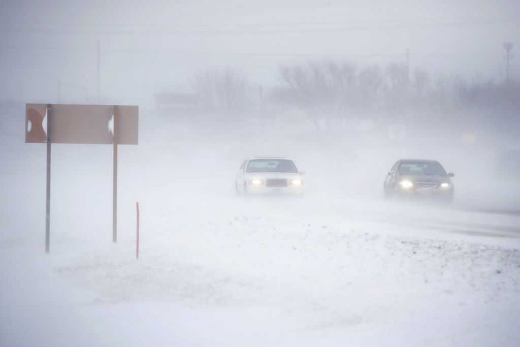
A powerful winter storm will push across the Midwest today bringing potential record setting snow to parts of Minnesota and Wisconsin, with blizzard conditions expected across much of Iowa.
Blizzard warnings are in place for nearly all of Iowa through Monday morning.
Here’s what to know:
Blizzard Warning
Hearst Owned
Blizzard Warning for most of Iowa through 7am Monday.
Most of Iowa is in a Blizzard Warning through 7 a.m. Monday morning. The combination of snow and wind gusts of 50 to 60mph with some stronger gusts will make travel treacherous or even impossible at times.
While snow totals are not expected to be extreme, the severe winds will result in blowing and drifting snow and low visibility regardless of exactly how much snow falls.
Watch: Snow moves into north central Iowa
Rain and storms early, then snow
Showers and storms will continue through mid-morning for central Iowa. A few storms could produce small hail, but no severe weather is expected. Farther north, colder conditions are already resulting in some slick roads north of Highway 18. Periods of rain, freezing rain, and some sleet will continue through mid-morning before changing over to snow.
Hearst Owned
Rain changing to snow across the state by Noon.
By late morning, most of far northern and northwest Iowa will be seeing snow. The rain to snow transition should reach the metro shortly after noon, with snow reaching southeast Iowa by 4pm.
Hearst Owned
Snow moving into central Iowa by 4pm
The period with the steadiest snowfall will likely come between 4 and 10pm for central Iowa with some periods of heavy snowfall possible in addition to the high winds.
Hearst Owned
Periods of heavy snow likely between 4 and 10pm
The now may initially be wet and heavy, but with quickly falling temperatures, expect the snow to become drier and fluffier allowing it to blow around easily. The snow will begin to taper off by 10pm and will likely be wrapping up for central Iowa by Midnight.
Hearst Owned
Snow wrapping up for central Iowa between 10pm and Midnight
Snow should be pushing out of eastern Iowa by 4 to 6am.
Snow totals are not expected to be extreme, with most of central Iowa only picking up a few inches of snow. Southwest Iowa will see the least, with most seeing less than 2 inches of snow, if that much. Central Iowa will generally see between 2 and 4 inches, with the metro more likely around 1 to 3 inches. Northern and eastern Iowa will see the most, with areas approaching or even exceeding 6 inches possible. However, the high winds will make it next to impossible to measure how much falls, and significant impacts will come from the blowing and drifting snow regardless of exact amounts.
Hearst Owned
Snow amounts generally around 2 or 3 inches for central Iowa, much heavier amounts to the north and east.
Severe winds Sunday evening, overnight
Hearst Owned
High Wind Warning through 4am for most of the state
A High Wind Warning is in place nearly state-wide through 4 a.m. Monday. A high wind warning means that severe to damaging wind gusts are expected across a wide area. Wind gusts of 50 to 60mph are likely during the strongest part of the storm, with some areas seeing gusts over 60mph.
The strongest winds will push in from the west across the state during the afternoon hours. Highs winds reach northwest Iowa by 3pm, and should push into the metro between 4 and 6pm. The strongest winds will last through 3am or so Monday morning. However, gusts of around 40mph are still likely during the morning drive on Monday.
Hearst Owned
Wind gusts of 50 to 60mph this evening and overnight.
The high winds will produce whiteout conditions for many, with full blown blizzard conditions likely at times. Extreme blowing and drifting snow can be expected, especially for rural areas. Roads may drift shut, becoming impassible at times. Urban areas can still expect significant blowing snow with poor visibility through the evening and overnight hours.
Frigid wind chills Monday
Temperatures will start in the 30s and 40s this morning, but will quickly fall this afternoon. Most will be in the teens 20s by this evening, with wind chills near zero.
Hearst Owned
Frigid wind chills overnight and early Monday
Frigid air will pour in overnight along with the high winds, with overnight lows in the single digits. Wind chills will fall into the -10 to -20 degree range throughout the morning hours on Monday making for some potentially dangerous cold along with the blowing snow.
What you need to know during winter weather
When winter weather hits in Iowa, KCCI has what you need to stay informed and safe.
For a look at travel conditions across Iowa, visit the Iowa DOT’s 511 website.
Viewers also help tell the story of the storm as it passes through. Submit photos and videos of the conditions you’re seeing on KCCI’s ulocal page.
View active closing and delays here
KCCI uses its website and social media pages to provide important information during winter storms.
Interact with KCCI Storm Team 8
Power outage resources:
Church service cancellations
More than two dozen churches have canceled Sunday services. Check our closings page for an updated list.
REPLAY: Watch Zane Satre’s extended weather from Saturday night
Zane Satre takes a deep dive into the latest severe weather outlook (as of 8 p.m. Saturday) and what’s to come Sunday on KCCI’s YouTube and Facebook pages.
This content is imported from YouTube.
You may be able to find the same content in another format, or you may be able to find more information, at their web site.
Polk County Extreme Temperature Plan in effect
In response to the extreme cold, Polk County will activate its Extreme Temperature Plan at 10 p.m. Sunday. The plan includes weather amnesty at area homeless shelters, activation of warming centers and free transportation to those locations on DART buses. All Des Moines Public Library locations are also serving as warming shelters during regular business hours.
Officials urge residents to call 911 if they see a person or pet in distress.
Keep an eye on flights in, out of Des Moines Airport
Spring break travelers may see weather-related delays and cancellations Sunday and Monday at the Des Moines International Airport. See the latest flight statuses here.
Keep an eye on weather across Iowa with KCCI’s skycams
Weather watchers can keep an eye on conditions by checking our skycam page, which shows aerial views from more than 25 sites across the state.
2 of 27
Des Moines: Iowa State Fairgrounds
3 of 27
Des Moines: Northeast mixmaster
4 of 27
Des Moines: Principal Park
5 of 27
Algona: Security State Bank
6 of 27
Altoona: Prairie Meadows Casino, Racetrack & Hotel
7 of 27
Ames: Flyover ramp
8 of 27
Ankeny: The District
9 of 27
Arnolds Park Amusement Park: West Lake Okoboji
10 of 27
Downtown Atlantic
11 of 27
Bettendorf: Iowa-Illinois Memorial Bridge
12 of 27
Boone: Scenic Valley Railroad
13 of 27
Boone: Seven Oaks Recreation
14 of 27
Council Bluffs: Bayliss Park
15 of 27
Council Bluffs: Lewis and Clark Monument Park
16 of 27
Creston Greater Regional Health
17 of 27
Indianola: Simpson College
18 of 27
Iowa City: University of Iowa Pentacrest
19 of 27
Lamoni: Amish Country Store
20 of 27
Malcom: Interstate 80
21 of 27
Marshalltown: Westown Apartments
22 of 27
Osceola: Interstate 35/Highway 34 overpass
23 of 27
Panora: Lake Panorama
24 of 27
Pella: The Amsterdam Hotel
25 of 27
Polk City: Big Creek Marina
26 of 27
West Des Moines Public Library
27 of 27
West Des Moines: West mixmaster
Make sure to clear your sidewalks
Des Moines municipal code requires property owners and tenants to remove snow and ice from sidewalks within 48 hours following the end of a snowfall. Property owners and tenants who do not comply are subject to a $75 administrative penalty for a first offense and larger penalties for repeat violations over a period of three years.
To report a sidewalk that hasn’t been cleared after 48 hours, call our Des Moines Public Works’ 24-Hour Customer Service Center at (515) 283-4950 or file a report online using this form or on the city’s mobile app.
KCCI Storm Team 8 weather
Storm Team 8 includes Chief Meteorologist Jason Sydejko and meteorologists David Koeller, Jon Rivas and Zane Satre.
Stay with KCCI online and on air for the most accurate central Iowa weather forecast.
Download the KCCI News app to get the most up-to-date weather alerts: iPhone | Android
Grab your ruler: Here’s how to accurately measure snowfall
If you are sending us snowfall reports, here are some good practices to use according to the National Weather Service to get the most accurate measurement possible.
- BEST PRACTICE: Use a snowboard (24”x16” piece of plywood), preferably white, to collect snow.
- A picnic table or deck without any interference from outside sources can work.
- If measuring from the ground, find an area with short grasses and be careful not to drive your yardstick into the ground so you don’t inflate the measurement.
- Use a yardstick for measuring.
- Avoid sheltered areas (sides of buildings & under trees).
- Be careful of large drifts.
- If snow has been blown or formed into drifts by wind, take an average of several high and low spots.