Arctic Blast: 5 things to know about Sunday’s winter storm
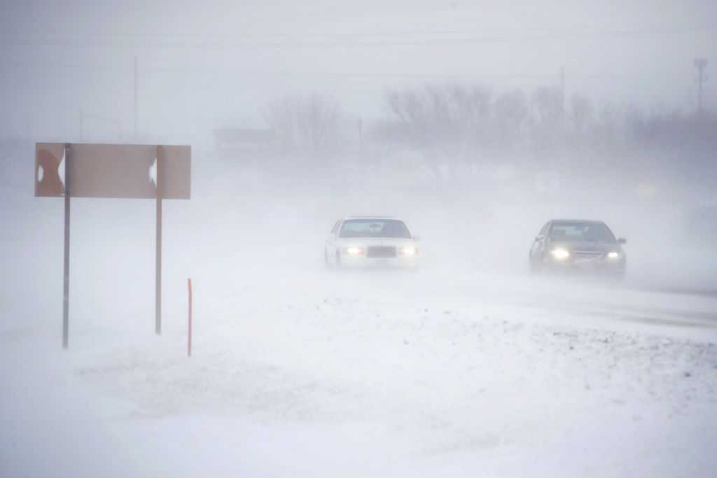
High winds and sharply falling temperatures blast in this morning with snow and blizzard conditions for parts of the state.
AND NO PRE-REGISTRATION IS REQUIRED. TIME NOW IS 515. AND DAVID, WE’VE HEARD THAT THERE COULD BE RAIN. THERE COULD BE SNOW. I MEAN, WOW, IT’S LIKE WE’RE LIVING IN TOTALLY DIFFERENT SEASONS TODAY. TELL US, WHAT CAN WE EXPECT? WE ARE GOING TO CRAM A LOT OF WEATHER INTO TODAY. IT IS A WEATHER IMPACT DAY. RIGHT NOW WE’RE TALKING ABOUT FOG THIS MORNING, BUT THAT’S QUICKLY GOING TO TURN TO RAIN AND THEN SNOW AND THEN HIGH WINDS AND THEN POTENTIAL BLIZZARD CONDITIONS ACROSS PARTS OF THE STATE. SO WE ARE WEATHER IMPACT HERE THROUGH EARLY TOMORROW MORNING BECAUSE OF THESE HIGH WINDS GUSTING 40 TO 55MPH PRODUCING BLOWING SNOW, ESPECIALLY IN NORTHERN IOWA. WE’RE ALSO GOING TO SEE CRASHING TEMPERATURES HERE THROUGHOUT THE DAY. AND WITH THE WET CONDITIONS THAT COULD LEAD TO A FEW SLICK ROADS JUST FROM THE COLDER TEMPERATURES MOVING IN. SO THAT’S SOMETHING ELSE TO KEEP IN MIND HERE AS WE HEAD THROUGH THE DAY. THE SNOW, THE BLOWING SNOW, THE BLIZZARD CONDITIONS, THAT’S MAINLY GOING TO BE FOR AREAS NORTH OF HIGHWAY 30 AND ESPECIALLY NORTH OF HIGHWAY 20. THAT’S WHERE WE HAVE A BLIZZARD WARNING NOTICE. THIS GOES UNTIL 9 A.M. ON MONDAY. THAT’S NOT NECESSARILY BECAUSE IT’S GOING TO SNOW ALL THE WAY INTO MONDAY, BUT THE HIGH WINDS WILL LAST INTO MONDAY MORNING AND THAT COULD LEAD TO CONTINUED BLOWING AND DRIFTING SNOW RIGHT ON THROUGH THE MORNING DRIVE TOMORROW ALONG AND NORTH OF HIGHWAY 30. WE HAVE A WINTER WEATHER ADVISORY, MUCH LIGHTER SNOW ACCUMULATION IN THIS AREA, BUT THE WIND WILL STILL CAUSE IT TO BLOW AROUND AND CAUSE SOME OCCASIONAL VISIBILITY ISSUES. YOU GET SOUTH OF HIGHWAY 30. WE’RE NOT GOING TO SEE MUCH SNOW OUT OF THIS, BUT THE HIGH WINDS STILL PICKING UP WHAT LITTLE SNOW WE HAVE AND PUSHING IT AROUND AS WE HEAD THROUGH THE AFTERNOON AND EVENING HOURS. RIGHT NOW WE ACTUALLY HAVE RAIN MOVING IN WITH TEMPERATURES IN THE 40S. WE’LL HAVE SOME ON AND OFF RAIN SHOWERS HERE THROUGH THE EARLY MORNING HOURS, BUT YOU NOTICE THAT SNOW BEGINS TO PICK UP IN NORTHWEST IOWA BY ABOUT 7:00 THIS MORNING AS THE COLDER AIR STARTS TO CRASH ON IN 9 A.M., WE’RE STILL 40 WITH SOME RAIN SHOWERS IN THE METRO, BUT CARROLL, YOU’RE DOWN TO 31. FORT DODGE 32. WITH THAT RAIN CHANGING OVER TO SNOW. AND THEN AS WE GET CLOSER TO THE LUNCH HOUR, NOTICE, OUR TEMPERATURES START TO FALL OFF DOWN TO 36 AT TEN. BY NOON, WE’RE DOWN TO 28. WE SEE THAT RAIN CHANGE OVER TO A WINTRY MIX BRIEFLY, AND THEN OVER TO A FEW BANDS OF SNOW. BUT NOTICE HERE WE ARE AT NOON, AND THEN BY ABOUT 3:00 THAT SNOW IS ALREADY TRYING TO PUSH OFF TO THE EAST, SO THE SNOW IS NOT GOING TO LAST VERY LONG HERE IN THE METRO. BUT WHAT SNOW WE DO GET WILL GET BLOWN AROUND BY THOSE HIGH WINDS. THE SNOW WILL LAST LONGER INTO THE AFTERNOON, INTO THE EVENING. HERE ACROSS FAR NORTHERN IOWA WE’RE TALKING AGAIN AREAS MAINLY NORTH OF HIGHWAY 20. THAT’S WHERE THAT SNOW CONTINUES INTO THE OVERNIGHT HOURS AND DOESN’T REALLY WIND DOWN UNTIL ABOUT TWO 3:00 EARLY ON MONDAY. THAT’S WHY THAT BLIZZARD WARNING IS IN PLACE THERE ACROSS NORTHERN IOWA. THAT’S WHERE THE SNOW IS GOING TO PILE UP A LITTLE BIT MORE. AND WE ARE TALKING THE POTENTIAL FOR TWO TO MAYBE UP TO FIVE INCHES. THOSE HIGHER TOTALS WILL BE RIGHT ALONG THE MINNESOTA BORDER. YOU GET DOWN TO ABOUT HIGHWAY 20. YOU’RE TALKING MAYBE 2 TO 3IN. YOU GET DOWN TO HIGHWAY 30 ABOUT MAYBE TWO INCHES, AND THEN DOWN TO THE METRO AN INCH, PROBABLY AT MOST. AND YOU GET SOUTH OF I-80. YOU’RE NOT GOING TO SEE MUCH SNOW OUT OF THIS AT ALL. SO IT’S NOT A HUGE SNOWSTORM, BUT THE WIND IS CAUSING ALL THE ISSUES. YOU CAN SEE. BY 10:00, THOSE WINDS START TO GUST UP OVER 40 MILES AN HOUR. AND AS WE HEAD INTO THE AFTERNOON, WE START TO SEE SOME OF THOSE POCKETS OF 45 TO 50 MILE AN HOUR WIND GUSTS. AND THOSE CONTINUE OVERNIGHT. HERE WE ARE AT MIDNIGHT, 6 A.M. MONDAY MORNING. WE STILL HAVE SOME OF THOSE HIGH WINDS, AND THAT’S WHY THAT BLIZZARD WARNING GOES THROUGH 9 A.M. TOMORROW MORNING THERE ACROSS NORTHERN IOWA. TEMPERATURES TODAY ARE GOING TO BE A BIT OF A MESS. WE’RE IN THE 40S NOW. WE’LL BE IN THE 20S BY NOON INTO THE TEENS THIS EVENING DOWN TO EIGHT BY TOMORROW MORNING. STILL LOOKING AT BLOWING SNOW ACROSS NORTHERN IOWA. TO START OFF YOUR MONDAY, A HIGH OF ONLY 17, WE RECOVER BACK INTO THE 30S FOR TUESDAY AND WEDNESDAY, BUT T
Arctic Blast: 5 things to know about Sunday’s winter storm
High winds and sharply falling temperatures blast in this morning with snow and blizzard conditions for parts of the state.
Updated: 6:20 AM CST Dec 28, 2025
Editorial Standards ⓘ
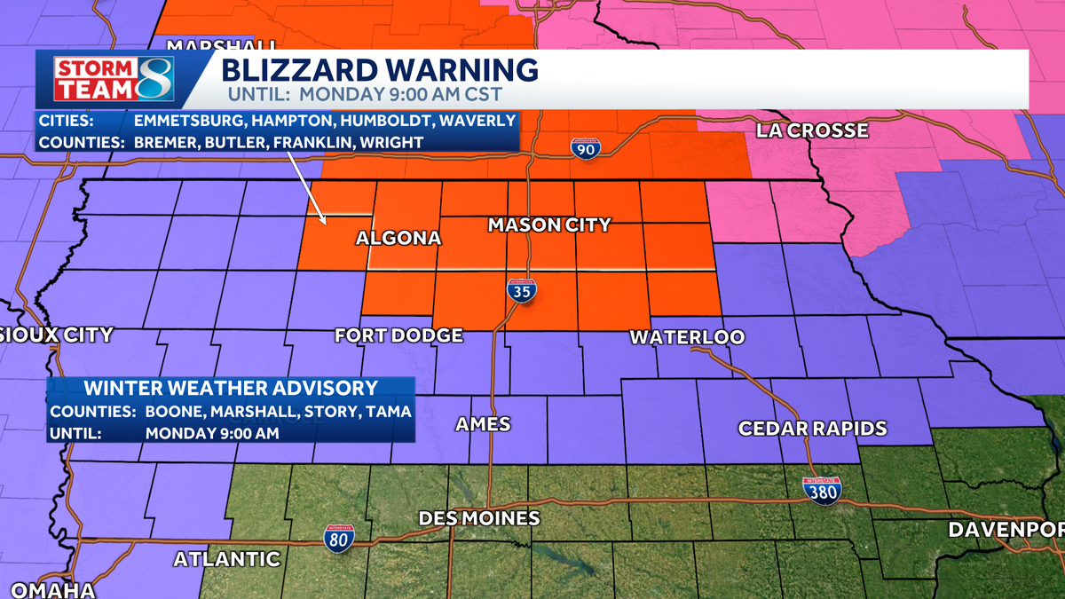
After a week of mild temperatures and foggy conditions, a round of winter weather is on the way tomorrow. A blizzard warning will be in effect through 9 a.m. Monday for several northern Iowa counties where 2-5 inches of snow will be accompanied by strong winds gusting up to 50 mph. A winter weather advisory will be in effect for counties along and north of Highway 30, and far western counties, through 6 a.m. Monday.Here’s what to know heading into Sunday’s arctic blast.Weather ImpactRain early in the morning will transition quickly to a wintry mix and then snow by Midday as colder air and high winds blast across the state. Blowing snow with some blizzard conditions will be a concern across far northern Iowa.Blizzard WarningA Blizzard Warning is in effect through 9 a.m. Monday for northern Iowa north of Highway 20. A more prolonged period of snow starting this afternoon and lasting into the overnight will drop 2 to 5 inches of snow, with the heaviest near the Minnesota border. Combined with wind gusts of 40 to 55mph, whiteout conditions and dangerous travel is expected through the overnight.High WindsNorthwest gusts of 35 to nearly 50mph can be expected this afternoon into Monday. This will create difficult driving conditions at times, even where snow is not expected to be a major concern.Snow ForecastWhile not a major snow event, 2 to 5 inches of snow is likely over northern and northeastern Iowa, the heaviest near the Minnesota border. Combined with the high winds, this will create dangerous travel conditions. Lighter amounts along the Highway 30 corridor of an inch or two. Less for the metro, around an inch, but with the wind this could still cause a few problems.Frigid Wind ChillsThe northwest gusts of 35 to 50mph will drop temperatures into the single digits by Monday morning, producing wind chills well below zero. Anyone spending time outdoors will need heavy winter gear.
DES MOINES, Iowa —
After a week of mild temperatures and foggy conditions, a round of winter weather is on the way tomorrow. A blizzard warning will be in effect through 9 a.m. Monday for several northern Iowa counties where 2-5 inches of snow will be accompanied by strong winds gusting up to 50 mph.
A winter weather advisory will be in effect for counties along and north of Highway 30, and far western counties, through 6 a.m. Monday.
Here’s what to know heading into Sunday’s arctic blast.
Weather Impact
Hearst Owned
High winds will bring frigid temperatures to all of Iowa, and blowing snow to northern parts of the state this afternoon.
Rain early in the morning will transition quickly to a wintry mix and then snow by Midday as colder air and high winds blast across the state. Blowing snow with some blizzard conditions will be a concern across far northern Iowa.
Blizzard Warning
Hearst Owned
Blizzard Warnings in effect for northern Iowa through 9am Monday. A winter weather advisory for areas near and north of Highway 30.
A Blizzard Warning is in effect through 9 a.m. Monday for northern Iowa north of Highway 20. A more prolonged period of snow starting this afternoon and lasting into the overnight will drop 2 to 5 inches of snow, with the heaviest near the Minnesota border. Combined with wind gusts of 40 to 55mph, whiteout conditions and dangerous travel is expected through the overnight.
High Winds
Hearst Owned
Powerful northwest winds with gusts of 40 to 55mph can be expected this afternoon through Monday morning.
Northwest gusts of 35 to nearly 50mph can be expected this afternoon into Monday. This will create difficult driving conditions at times, even where snow is not expected to be a major concern.
Snow Forecast
Hearst Owned
The heaviest snow will fall over far northern Iowa where blizzard conditions are possible.
While not a major snow event, 2 to 5 inches of snow is likely over northern and northeastern Iowa, the heaviest near the Minnesota border. Combined with the high winds, this will create dangerous travel conditions. Lighter amounts along the Highway 30 corridor of an inch or two. Less for the metro, around an inch, but with the wind this could still cause a few problems.
Frigid Wind Chills
Hearst Owned
Frigid wind chills of -10 to -20 degrees early Monday morning.
The northwest gusts of 35 to 50mph will drop temperatures into the single digits by Monday morning, producing wind chills well below zero. Anyone spending time outdoors will need heavy winter gear.