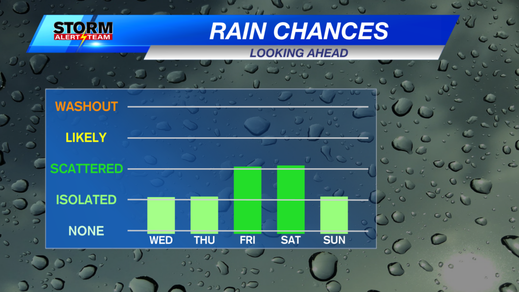
Isolated rain chances remain possible on Wednesday and Thursday, with more widespread chances for showers expected through Halloween weekend.
Short-range runs of StormCast show a line of showers and thunderstorms developing in far eastern Nebraska late Wednesday afternoon, moving east through the evening and overnight.
Portions of western and central Nebraska could see areas of reduced visibility on Wednesday morning. A Dense Fog Advisory is in place until 11 a.m. CDT (10 a.m. MDT) on Wednesday, with visibility down to a quarter mile or less possible.
We will see our closest chance of severe weather in some time on Wednesday evening. Portions of western Iowa up towards the Twin Cities are under a Marginal Risk (Level 1 out of 5) of severe weather. Large hail and damaging winds would be the main concerns in the strongest storms. Keep up to date with the latest forecast should this risk shift further west.
-
8 AM Friday, October 30, 2026
-
8 PM Friday, October 30, 2026
-
12 PM Saturday, October 31, 2026
-
10 PM Saturday, October 31, 2026
While we continue to refine the timing and exact location of precipitation, here is a look at our chances for showers and possibly a few thunderstorms heading into Halloween night.
Long-term models still like our chances of seeing a strong disturbance in the central plains early next week. Several rounds of rainfall could bring a healthy amount of moisture to our rain gauges over the next 7 days.
Overnight lows drop to the 40s and 50s across the state, with temperatures not expected to budge much through the overnight in far southeast Nebraska.
A brief shower or two remains possible tonight in Lincoln, though most of us will likely stay dry.
Southerly winds will usher in warmer temperatures for central and eastern Nebraska, with highs back into the 70s for most!
We will see warm fall temperatures in the Capital City on Wednesday with a southerly wind. There is a small chance of a shower or thunderstorm close to evening commute.
Winds are expected to be a bit gusty throughout Wednesday afternoon. Gusts could reach up to 35 miles per hour in southeast Nebraska.
Temperatures back off on Thursday afternoon with more sunshine and an easterly wind.
The long-term forecast is riddled with chances of showers and possibly a thunderstorm or two. Keep an eye on the radar for those trick-or-treating, as well as those heading to the Husker football game Saturday evening. Fall-like temperatures return by the start of November, with rain chances continuing at least through Election Day.
Storm Alert Team Meteorologist
Dominic Ferraro
X: DomFerraroWX
Facebook: DomFerraroWX
YouTube: DomFerraroWX
Categories: Channel 8 Eyewitness News Weather, Forecast
Tags: Aurora, Beatrice, forecast, Grand Island, Hastings, isolated showers, Kearney, lincoln, McCook, mostly sunny, seward, warming up, weather, weekend rain