The first half of our snowy January weekend is complete. Top snowfall totals around North Jersey ended up around 4 to 5 inches. The snow really poured from the sky at times Saturday. Farther south, snow mixed with rain, although making things messy (although decidedly less pretty and white). Most of the Garden State dealt with several hours of sloppy travel conditions.
And guess what … We are going to do it all over again on Sunday.
As I hinted in Saturday morning’s weather blog update, model guidance had started to shift toward a closer, snowier track for our next coastal storm arriving on Sunday. While one model run is not enough to change a forecast, this trend continued with Saturday afternoon’s entire guidance suite. So now it is time to get on board with the westward nudge.
In general, this change means a more widespread, longer duration, and heavier snow for New Jersey. All 21 counties of the state could now see accumulating snow during the day on Sunday. However, there are some additional complications here, as warmer temperatures now come into play along the southern coast, adding raindrops to the mix.
For this Saturday evening forecast update, I threw all previous snow maps out the window and started fresh. Let’s run down everything you need to know for Sunday to plan ahead and stay safe.
Timeline
Saturday night will be quiet, calm, and cold. Low temperatures will dip into the upper 20s or so. Freezing temperatures means there will be icy spots around, so watch your step and drive carefully.
Sunday’s coastal storm looks like it could be an all-day event. (Although that does not necessarily mean it will be snowing everywhere at all times.) Initial spotty snow showers may bubble up from the southwest just before sunrise Sunday morning. And then the main event, steadier precipitation will get started around 7 or 8 a.m. For the vast majority of the state, temperatures will be at or below the freezing mark for the duration of the storm. However, far southern New Jersey will be in the mid 30s at onset, meaning several hours in the morning could stay wet before transitioning to snowy by midday.
At least one model — the short-duration high-resolution HRRR — shows a lull in the storm coming in around midday. That is not a guarantee, but we are always on the lookout for dry spots and breaks during winter storms.
Things should largely wind down starting around sunset Sunday evening, with final snowflakes exiting New Jersey by 8 or 9 p.m.
Accumulations
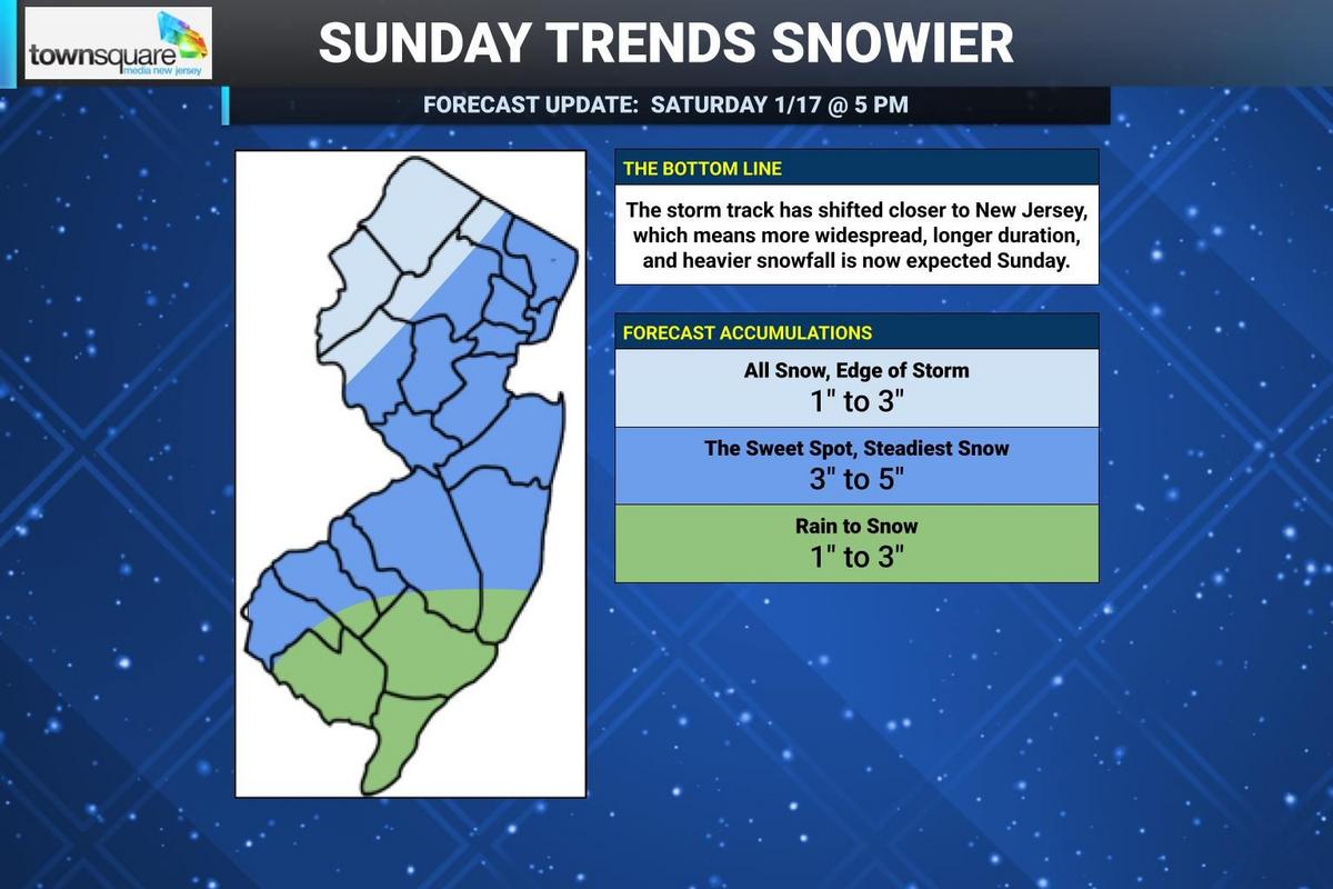
Update on Sunday’s snowy coastal storm forecast, as of Saturday evening. (Dan Zarrow, Townsquare Media)Update on Sunday’s snowy coastal storm forecast, as of Saturday evening. (Dan Zarrow, Townsquare Media)
It looks like a swath right through the middle of New Jersey will be the “sweet spot” of this storm, picking up about 3 to 5 inches of total snowfall. This includes northeastern, central, and southwestern New Jersey along with the northern half of the Jersey Shore. (See map for details.) Keep in mind, some of this area already has 2 or 3 inches of snow on the ground, so it is going to be quite a winter wonderland here to close out the weekend.
To the north, I think the area around Sussex, Warren, Morris, and Passaic counties will fall out of the steadiest, heaviest snow bands. So I have painted lower snow totals for far northern New Jersey, on the order of 1 to 3 inches. It is important to keep in mind that some model forecast, including the very latest NAM run, does put this corner of the state in the “sweet spot” band. But I have to play the odds on my forecast map and think dry air and light snow win out to the north and west this time around.
To the south, as I mentioned, a period of rain is looking likely as temperatures hold around 35 to 38 degrees as the storm gets started Sunday morning. This is a side effects of a closer storm track — the storm system drags slightly warmer air along with it. The geography of such mixing is limited, to the area in and around Cape May County. But still, any period of rain would limit final snow totals. So I have kept forecast accumulations to a slushy 1 to 3 inches for the bottom of the state as a result.
Advisories
The National Weather Service just put out a swath of advisories on either side of the NJ Turnpike corridor, lining up nicely with my “sweet spot” forecast above.
A Winter Weather Advisory has been issued for the following 15 New Jersey counties for the following times:
—6 a.m. to 8 p.m. Sunday…Northwestern Burlington, Camden, Gloucester, Hunterdon, Mercer, Middlesex, inland Monmouth, Morris, Salem, Somerset
—7 a.m. to 10 p.m. Sunday… Bergen, Essex, Hudson, Union, eastern Passaic.
An advisory is a formal heads-up that wintry weather could cause hazardous travel conditions due to snowy, icy, slippery roads. Nothing more, nothing less. In New Jersey, advisories are issued when 2 to 3 inches of snow are in the forecast within a period of 12 hours.
Impacts
Again, it’s all about travel. Not a major storm, but there will be problems on the roads due to poor traction and low visibility. And this is a daytime storm, so there will be traffic headaches.
Even though this is a coastal storm, I do not anticipate any significant icing, wind, waves, or coastal flooding. It’s just a light to moderate snow event for New Jersey.
Confidence
Confidence is better, now that models are in agreement in terms of snowfall magnitude and intensity and timing. However, the storm track may still “wiggle” over the next 12 to 24 hours as the storm arrives and ramps up. Even a small deviation now could result in that 3 to 5 inch “sweet spot” shifting as well. And I will be honest: I believe there are equal chances that it shifts in either direction.
Is there a chance we get even more than 5 inches of snow? At least once model run I saw put 6+ inches of accumulation over part of northeastern New Jersey, so I would not rule it out. Plus, after Saturday’s overperformance and dynamic cooling, I would say the atmosphere is prime to produce some healthy snowfall.
As with many track-dependent storms, this one is very last-minute and very play-it-by ear. Over the course of the past week, the forecast has gone from “big storm” to “nothing-burger” to “inch or two for some” to “accumulating snow for all”. It will be very interesting to see how it continues to play out.
What Comes Next?
I will publish one more weather blog update early Sunday morning just before the storm starts, as we get one more round of data and insight. And then we will do our best to stay on top of the storm’s twists and turns as it moves in and out on Sunday.
After the storm, snow will stay on the ground for a while as temperatures stay frigid this week. Dangerous cold remains a possibility by Tuesday morning, as wind chills descend to near zero. Don’t expect a warmup or end to snow threats anytime soon.
5 DAY FORECAST: New Jersey Weather Center
Let it snow: 12 things to know about winter forecasting in NJ
Gallery Credit: Dan Zarrow
Dan Zarrow is Chief Meteorologist for Townsquare Media New Jersey. Follow him on Facebook for the latest forecast and realtime weather updates.
10 tips for surviving winter in New Jersey
Gallery Credit: Kyle Clark


