STORM DOWNED POWER LINES ACROSS THE COUNTY. WE COULD BE IN FOR ANOTHER ROCKY AFTERNOON AND EVENING, ESPECIALLY THE SOUTHERN PART OF THE STATE ONCE AGAIN. DAVID. YEAH, EXACTLY. WE COULD BE LOOKING AT A PRETTY SIMILAR SETUP TO WHAT WE HAD YESTERDAY IN THAT WE HAVE PRETTY CHILLY CONDITIONS ACROSS MOST OF THE STATE RIGHT NOW, BUT EVENTUALLY WE’RE GOING TO SEE A SURGE OF WARMER AIR INTO SOUTHERN IOWA. AND THAT’S GOING TO BRING THE ENERGY FOR ANOTHER ROUND OF STRONG TO POTENTIALLY SEVERE THUNDERSTORMS. SO WE ARE GOING TO BE WATCHING THAT POTENTIAL FOR MOST OF THE STATE. THE RISK IS A LITTLE BIT LOWER BECAUSE OF THE COLDER CONDITIONS. THAT TORNADO RISK THAT’S GOING TO BE LIMITED TO MAINLY SOUTHERN IOWA. REALLY LOOKING AT AREAS SOUTH OF HIGHWAY 34 FOR THAT TORNADO RISK. HOWEVER, THE HAIL RISK IS GOING TO BE A LITTLE BIT MORE WIDESPREAD BECAUSE YOU DON’T NECESSARILY HAVE TO HAVE WARM SURFACE TEMPERATURES TO HAVE SOME HAIL RISK, BECAUSE YOU CAN STILL HAVE SOME INSTABILITY UP IN THE UPPER LEVELS OF THE ATMOSPHERE. SO THAT COULD STILL RESULT IN SOME HAIL WITH SOME THUNDERSTORMS. EVEN HERE IN CENTRAL IOWA. BUT THE TORNADO RISK, THE HIGH WIND RISK THAT’S GENERALLY GOING TO BE LIMITED TO SOUTHERN IOWA. SO THAT RISK A LITTLE BIT LOWER HERE FOR MOST OF THE STATE AND NOT REALLY TOO WORRIED ABOUT FLOODING TODAY, AS WE HAVE BEEN PRETTY DRY OVER THE PAST SEVERAL WEEKS. SO ANY RAIN WE GET WILL GENERALLY BE ABLE TO RUN INTO THE CREEKS AND STREAMS. OKAY, BUT SOME URBAN PONDING, WATER ON ROADWAYS, THINGS LIKE THAT, THAT COULD BE AN ISSUE HERE IS THAT SEVERE WEATHER RISK AND IT LOOKS PRETTY SIGNIFICANT FOR AREAS ALONG AND SOUTH OF I-80. BUT REALLY GOING TO TELL YOU, IT LOOKS LIKE WE’RE GOING TO FOCUS IN ON AREAS SOUTH OF HIGHWAY 34. THAT’S WHERE WE’RE GOING TO HAVE THAT WIND, HAIL AND TORNADO RISK. IT’S GOING TO BE FOR FAR SOUTHERN IOWA. YOU GET NORTH OF THE HIGHWAY THERE CLOSER TO I-80 UP INTO THE METRO. WE’RE PRETTY CHILLY RIGHT NOW. OUR TEMPERATURES ARE GOING TO WARM ALL THAT MUCH. THAT’S GOING TO LEAVE US WITH MAINLY JUST A HAIL RISK HERE FOR CENTRAL AND NORTHERN IOWA. WITH ANY THUNDERSTORMS THAT ARE ABLE TO DEVELOP HERE LATER TODAY. WE’VE HAD SOME STORMS OUT THERE ALREADY. IN FACT, WE HAVE STORMS ONGOING HERE NORTHEAST OF THE METRO. LOOKS LIKE WE HAVE ANOTHER LITTLE POCKET OF STORMS THAT HAS POPPED UP HERE JUST WEST OF TOWN, MOVING THROUGH ADEL AND WINTERSET, ABOUT TO MOVE INTO WAUKEE AND WEST DES MOINES HERE SHORTLY. THIS IS NOT SEVERE. IT’S GOING TO BRING SOME HEAVY DOWNPOURS, CERTAINLY SOME LIGHTNING AND THUNDER, BUT NO SEVERE WEATHER WITH ANY OF THAT. WE’RE WATCHING THE ZONE BACK HERE WHERE WE HAVE A LITTLE BIT OF CLEARING, SOME SLIGHTLY WARMER AIR. THAT’S WHERE THE POTENTIAL FOR SEVERE WEATHER WILL BEGIN HERE LATER THIS AFTERNOON. IT’S RIGHT ALONG THIS STORM SYSTEM AS THIS LIFTS TO THE EAST INTO THE NORTHEAST, IT’S GOING TO BRING THAT WARMER AIR UP INTO SOUTHERN IOWA. AND THEN THAT COLD FRONT, THAT CLASH OF SEASONS RIGHT THERE, WILL HELP TO KICK OFF SOME OF THOSE THUNDERSTORMS, CURRENTLY 42 DEGREES HERE IN DES MOINES. IT’S PRETTY CHILLY OUT THERE. YOU CAN SEE THE DRIZZLE, THE MIST, THE RAIN THAT’S COMING DOWN RIGHT NOW DOES NOT FEEL LIKE A SEVERE WEATHER DAY. AND FOR THE MOST PART, YOU’D BE RIGHT. IT DOES NOT FEEL LIKE A SEVERE WEATHER DAY, ESPECIALLY AS YOU GET NORTH OF I-80 WHERE WE HAVE TEMPERATURES THAT ARE IN THE 30S RIGHT NOW. THAT’S REALLY GOING TO HOLD DOWN THAT SEVERE WEATHER RISK. BUT NOTICE IT DOES GET A LITTLE BIT WARMER AS YOU GET CLOSER TO MISSOURI, 50 IN CENTERVILLE, 50 IN CLARINDA YOU GET DOWN INTO MISSOURI, LOOK AT THAT 73 IN KANSAS CITY, 78 IN COLUMBIA, MISSOURI. THAT’S THE WARMER AIR THAT IS GOING TO BE SURGING NORTHWARD HERE. AS WE HEAD INTO THE AFTERNOON. YOU CAN SEE THAT HAPPENING AS WE GET TOWARD 3:00, TEMPERATURES GETTING CLOSER TO 60 DEGREES ALONG THE MISSOURI BORDER. THE 60 DEGREE TEMPERATURES PUSH THEIR WAY UP TOWARD ABOUT HIGHWAY 34. THAT’S REALLY GOING TO BE THE THE LINE WHERE WE SEE THAT SEVERE WEATHER POTENTIAL INCREASE ONCE TEMPERATURES GET CLOSER TO 60. SO YOU SEE THOSE 60S THERE. SHERIDAN OVER TO OTTAWA, DOWN TOWARD LAMONI AND CENTERVILLE. THAT’S WHERE THAT SEVERE WEATHER RISK IS GOING TO BE AS THE COLD FRONT THEN SWINGS IN LATER THIS EVENING, WHERE TEMPERATURES REMAIN IN THE 40S. VERY LIMITED SEVERE WEATHER RISK, MAINLY LOOKING AT POSSIBLY SOME HAIL. SO WHEN DOES ALL THIS HAPPEN? WELL, IT LOOKS LIKE THOSE STORMS START TO FIRE UP MAYBE AS EARLY AS 3 TO 4:00. COULD HAVE A COUPLE OF LINES OF STORMS OUT THERE. THE MORE SIGNIFICANT LINE IS GOING TO BE THIS ONE BACK HERE NEAR CLARINDA, YOU CAN SEE THAT SOUTH OF I-80 PUSHING UP TOWARD THE I-35 CORRIDOR BY ABOUT 5:00 OR SO. STRONGEST STORMS SOUTH OF I-80, AND THEN THEY CONTINUE TO PUSH EASTWARD BY ABOUT 6 TO 7:00. AND I THINK BY 8:00 THIS EVENING, THOSE STORMS ARE MOSTLY OUT OF HERE. SO THAT 4 TO 8:00 WINDOW, THAT’S WHERE WE COULD SEE SOME OF THOSE SEVERE STORMS HERE THIS EVENING. AND THEN THEY’RE OUT OF HERE OVERNIGHT, TURNING COOLER AND WINDY TOMORROW
Iowa weather: Tornadoes, strong wind, hail, heavy rain all possible again today
Iowa weather: Storms with heavy rain, hail, wind, and possibly tornadoes today
Updated: 2:35 PM CDT Apr 3, 2026
Editorial Standards ⓘ
Multiple rounds of thunderstorms blew across the southern half of the state yesterday, triggering a wide tornado watch and several tornado and severe thunderstorm warnings. We expect additional severe weather today, with the main threats being damaging winds and large hail.Interactive Radar | Weather Alerts | Latest forecast | SkycamsHere’s what to know. Tornado watch for southern Iowa countiesA tornado watch is in effect for 16 southern Iowa counties through 10 p.m. Friday. Those counties include Appanoose, Clarke, Davis, Decatur, Des Moines, Henry, Jefferson, Lee, Lucas, Monroe, Ringgold, Taylor, Union, Van Buren, Wapello and Wayne.Keep an eye on weather across Iowa with KCCI’s skycamsWeather watchers can keep an eye on conditions by checking our skycam page, which shows aerial views from more than 25 sites across the state.Today’s stormsAlthough the morning was cold and damp, a strong area of low pressure will draw more warm and humid air into southern Iowa this afternoon, providing fuel for additional storms.The next round of storms are expected to form by 2 to 4 pm in southwest Iowa and northwest Missouri.Storms should reach the I-35 corridor between 4 and 7 pm, with the highest risk for significant severe weather mainly south of Highway 34. Some large hail will be possible as far north as Highway 30, including the metro area.The main thing to watch is how long it takes the warm, moist air to lift into Iowa from the south and how far north it goes before nightfall. Where temperatures remain cool all day, the severe weather risk be extremely limited, or nonexistent. The line for the most significant severe weather again appears to be near and south of Highway 34, with mainly a hail risk north of that line.For areas that will warm up, we will see all types of severe weather will be possible. Strong winds and large hail will be the highest threats with a couple tornadoes possible. The areas that have the most favorable conditions for these stronger storms will be southern Iowa and northern Missouri. WATCH: Strong winds toss large metal shed in southwest IowaIowa weather: ‘Incredibly large hail’ reported in Ottumwa areaIllustrating hail size referencesTraditionally, common objects like peas and golf balls and softballs have been used to describe the hail you may see. This image helps with those references.WATCH: KCCI skycam shows moment blanket of fog switches directions over downtown Des MoinesHere’s how to make sure your phone provides severe weather alertsWhen storms are in the forecast, you want to make sure your mobile phone settings allow for alerts that warn you of severe weather.The U.S. Homeland Security Department says to check your phone’s settings and ensure you have “Government Alerts” or “Emergency Alert Messages” enabled.You can keep track of the weather wherever you are with the KCCI app: Apple | Google PlayWe’ll send you weather alerts and you can track live radar right on your phone.Weather Aware: How to make sure your phone provides severe weather alerts Tornado safety tipsIf you are in a home, small building, nursing home, hospital, factory, shopping center or high-rise building:Go to a pre-designated area such as a safe room, basement, storm cellar or the lowest building level. If there is no basement, go to the center of a small interior room on the lowest level (closet, interior hallway) away from corners, windows, doors and outside walls. Put as many walls as possible between you and the outside. Get under a sturdy table and use your arms to protect your head and neck.If you are in a pickup line at your child’s school, get inside the building as quickly as possible.In a high-rise building, go to a small interior room or hallway on the lowest floor possible.Make sure you are wearing sturdy shoes.Do not open windows.If you are in a mobile home, manufactured office building or camper:Get out immediately and go to a pre-identified location such as the lowest floor of a sturdy nearby building or a storm shelter. Mobile homes, even if tied down, offer little protection from tornadoes.If you are not in a sturdy building, there is no single research-based recommendation for what last-resort action to take because many factors can affect your decision.Possible actions (which do not guarantee safety) include:Immediately get into a vehicle, buckle your seat belt and try to drive to the closest sturdy shelter. If your vehicle is hit by flying debris while you are driving, pull over and park.Take cover in a stationary vehicle. Put the seat belt on and cover your head with your arms and a blanket, coat or cushion if possible.Lie in an area noticeably lower than the level of the road and cover your head with your arms and a blanket, coat or cushion if possible.Understanding the Enhanced Fujita ScaleThe National Weather Service uses the Enhanced Fujita Scale, or EF-Scale, to assign tornado ratings based on estimated wind speeds and related damage.The Enhanced Fujita Scale, which replaced the earlier Fujita Scale in February 2007, categorizes tornadoes by degree of damage indicators and associates that damage with estimated wind speeds for three-second gusts.Enhanced Fujita Scale levelsEF0 (weak): 65-85 mph wind gustsEF1 (weak): 86-110 mph wind gustsEF2 (strong): 111-135 mph wind gustsEF3 (strong): 136-165 mph wind gustsEF4 (violent): 166-200 mph wind gustsEF5 (violent): Over 200 mph wind gusts
DES MOINES, Iowa —
Multiple rounds of thunderstorms blew across the southern half of the state yesterday, triggering a wide tornado watch and several tornado and severe thunderstorm warnings. We expect additional severe weather today, with the main threats being damaging winds and large hail.
Interactive Radar | Weather Alerts | Latest forecast | Skycams
Here’s what to know.
Tornado watch for southern Iowa counties
A tornado watch is in effect for 16 southern Iowa counties through 10 p.m. Friday.
Those counties include Appanoose, Clarke, Davis, Decatur, Des Moines, Henry, Jefferson, Lee, Lucas, Monroe, Ringgold, Taylor, Union, Van Buren, Wapello and Wayne.
Hearst Owned
A tornado watch is in effect for 16 southern Iowa counties through 10 p.m. Friday.
Keep an eye on weather across Iowa with KCCI’s skycams
Weather watchers can keep an eye on conditions by checking our skycam page, which shows aerial views from more than 25 sites across the state.
2 of 27
Des Moines: Iowa State Fairgrounds
3 of 27
Des Moines: Northeast mixmaster
4 of 27
Des Moines: Principal Park
5 of 27
Algona: Security State Bank
6 of 27
Altoona: Prairie Meadows Casino, Racetrack & Hotel
7 of 27
Ames: Flyover ramp
8 of 27
Ankeny: The District
9 of 27
Arnolds Park Amusement Park: West Lake Okoboji
10 of 27
Downtown Atlantic
11 of 27
Bettendorf: Iowa-Illinois Memorial Bridge
12 of 27
Boone: Scenic Valley Railroad
13 of 27
Boone: Seven Oaks Recreation
14 of 27
Council Bluffs: Bayliss Park
15 of 27
Council Bluffs: Lewis and Clark Monument Park
16 of 27
Creston Greater Regional Health
17 of 27
Indianola: Simpson College
18 of 27
Iowa City: University of Iowa Pentacrest
19 of 27
Lamoni: Amish Country Store
20 of 27
Malcom: Interstate 80
21 of 27
Marshalltown: Westown Apartments
22 of 27
Osceola: Interstate 35/Highway 34 overpass
23 of 27
Panora: Lake Panorama
24 of 27
Pella: The Amsterdam Hotel
25 of 27
Polk City: Big Creek Marina
26 of 27
West Des Moines Public Library
27 of 27
West Des Moines: West mixmaster
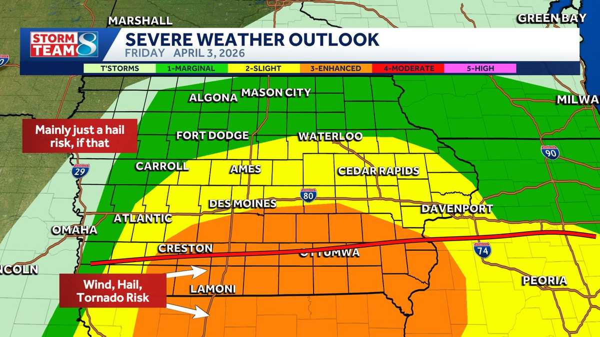
Today’s storms
Although the morning was cold and damp, a strong area of low pressure will draw more warm and humid air into southern Iowa this afternoon, providing fuel for additional storms.
Hearst Owned
Severe weather risk across Iowa for Friday afternoon.
The next round of storms are expected to form by 2 to 4 pm in southwest Iowa and northwest Missouri.
Hearst Owned
Storms developing across southwest Iowa by 2 to 4pm.
Storms should reach the I-35 corridor between 4 and 7 pm, with the highest risk for significant severe weather mainly south of Highway 34. Some large hail will be possible as far north as Highway 30, including the metro area.
Hearst Owned
Storms pushing east across southern Iowa by 5pm.
The main thing to watch is how long it takes the warm, moist air to lift into Iowa from the south and how far north it goes before nightfall. Where temperatures remain cool all day, the severe weather risk be extremely limited, or nonexistent. The line for the most significant severe weather again appears to be near and south of Highway 34, with mainly a hail risk north of that line.
Hearst Owned
Significant severe weather possible south of Hwy 34 with large hail, high winds, and tornadoes possible.
For areas that will warm up, we will see all types of severe weather will be possible. Strong winds and large hail will be the highest threats with a couple tornadoes possible. The areas that have the most favorable conditions for these stronger storms will be southern Iowa and northern Missouri.
Hearst Owned
Biggest risk for most of the state will be hail, with high winds and tornadoes possible in southern Iowa.
WATCH: Strong winds toss large metal shed in southwest Iowa
Iowa weather: ‘Incredibly large hail’ reported in Ottumwa area
Illustrating hail size references
Traditionally, common objects like peas and golf balls and softballs have been used to describe the hail you may see. This image helps with those references.
Hearst Owned
Some large hail is possible in the storms expected to blow across Iowa this week. Here’s a size comparison.
WATCH: KCCI skycam shows moment blanket of fog switches directions over downtown Des Moines
Here’s how to make sure your phone provides severe weather alerts
When storms are in the forecast, you want to make sure your mobile phone settings allow for alerts that warn you of severe weather.
The U.S. Homeland Security Department says to check your phone’s settings and ensure you have “Government Alerts” or “Emergency Alert Messages” enabled.
You can keep track of the weather wherever you are with the KCCI app: Apple | Google Play
We’ll send you weather alerts and you can track live radar right on your phone.
Weather Aware: How to make sure your phone provides severe weather alerts
Tornado safety tips
If you are in a home, small building, nursing home, hospital, factory, shopping center or high-rise building:
- Go to a pre-designated area such as a safe room, basement, storm cellar or the lowest building level. If there is no basement, go to the center of a small interior room on the lowest level (closet, interior hallway) away from corners, windows, doors and outside walls. Put as many walls as possible between you and the outside. Get under a sturdy table and use your arms to protect your head and neck.
- If you are in a pickup line at your child’s school, get inside the building as quickly as possible.
- In a high-rise building, go to a small interior room or hallway on the lowest floor possible.
- Make sure you are wearing sturdy shoes.
- Do not open windows.
If you are in a mobile home, manufactured office building or camper:
- Get out immediately and go to a pre-identified location such as the lowest floor of a sturdy nearby building or a storm shelter. Mobile homes, even if tied down, offer little protection from tornadoes.
If you are not in a sturdy building, there is no single research-based recommendation for what last-resort action to take because many factors can affect your decision.
Possible actions (which do not guarantee safety) include:
- Immediately get into a vehicle, buckle your seat belt and try to drive to the closest sturdy shelter. If your vehicle is hit by flying debris while you are driving, pull over and park.
- Take cover in a stationary vehicle. Put the seat belt on and cover your head with your arms and a blanket, coat or cushion if possible.
- Lie in an area noticeably lower than the level of the road and cover your head with your arms and a blanket, coat or cushion if possible.
Understanding the Enhanced Fujita Scale
The National Weather Service uses the Enhanced Fujita Scale, or EF-Scale, to assign tornado ratings based on estimated wind speeds and related damage.
The Enhanced Fujita Scale, which replaced the earlier Fujita Scale in February 2007, categorizes tornadoes by degree of damage indicators and associates that damage with estimated wind speeds for three-second gusts.
Enhanced Fujita Scale levels
- EF0 (weak): 65-85 mph wind gusts
- EF1 (weak): 86-110 mph wind gusts
- EF2 (strong): 111-135 mph wind gusts
- EF3 (strong): 136-165 mph wind gusts
- EF4 (violent): 166-200 mph wind gusts
- EF5 (violent): Over 200 mph wind gusts