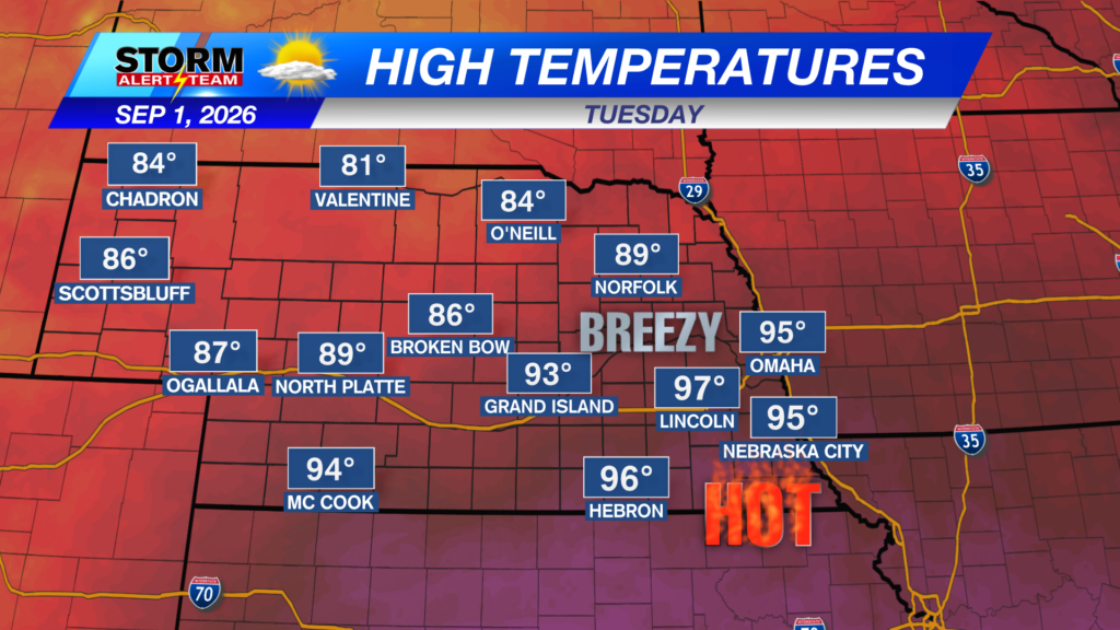
A warm/HOT day is in store across Nebraska under mostly/partly sunny skies! High temperatures will range from 83° – 99° with dew points in the 60s & 70s! A cold front will stall north of I-80 this afternoon, hint: the 80s for highs further north.
Heat index values could exceed 104° during the peak afternoon across eastern Nebraska.
Strong storms capable of 65-75+ mph winds,golf ball a brief tornado & heavy rain will move ENE this evening across north central Nebraska. *TIMING: 5pm-midnight*
6-8pm: Isolated storms develop across north central Nebraska. A line from Valentine down to Broken Bow.
-70+ mph winds, large hail & a brief spin up will all be possible with these 1st initial storms.
9-midnight: Storms track ENE, carrying gusty winds & small hail. A brief spin up could occur in far NE Nebraska near 7-9pm.
Rainfall potential through Wednesday morning look to favor north central Nebraska. Potential rainfall totals will range from 0.75″-2.50″+, with the heavier totals in NE Nebraska.
A HOT & HUMID start to September! Wednesday & Thursday turn hot & windy. The best rain chances will stay along a SW->NE pattern through this week. By the 2nd week of September, some changes could be near including more rain chances & cooler air. Some severe weather could also exist as our next front approaches next week.
Meteorologist Houston Hall
Facebook: HHallWX
YouTube: HHallWX
Tags: #klkntv, Beatrice, channel 8 weather, damaging winds, forecast, Grand Island, hail, Hastings, heat, hot, Humid, lincoln, McCook, Nebraska, North Platte, Omaha, rain, severe weather, tornado, warm, weather, Wind