Spring is trying to flex its muscles, and for the next 48 hours, it’s going to put on quite a show.
Warm air has settled in Boston, and temperatures have the chance to challenge records in inland parts of Massachusetts.
Of course March is always fickle, and winter cold isn’t too far away from New England. Expect a bit of a snap back to reality later this week as cooler air returns — along with a chance for a coating of snow Thursday night.
Record warmth watch
Monday feels so pleasant, with highs topping out in the 60s for many. The last 60-plus degree reading for Boston was way back at the end of November. On average, Boston usually hits 60 degrees on Feb. 19. Last year, the city had its first 60-degree day on March 11, so this timing is very similar to last year.
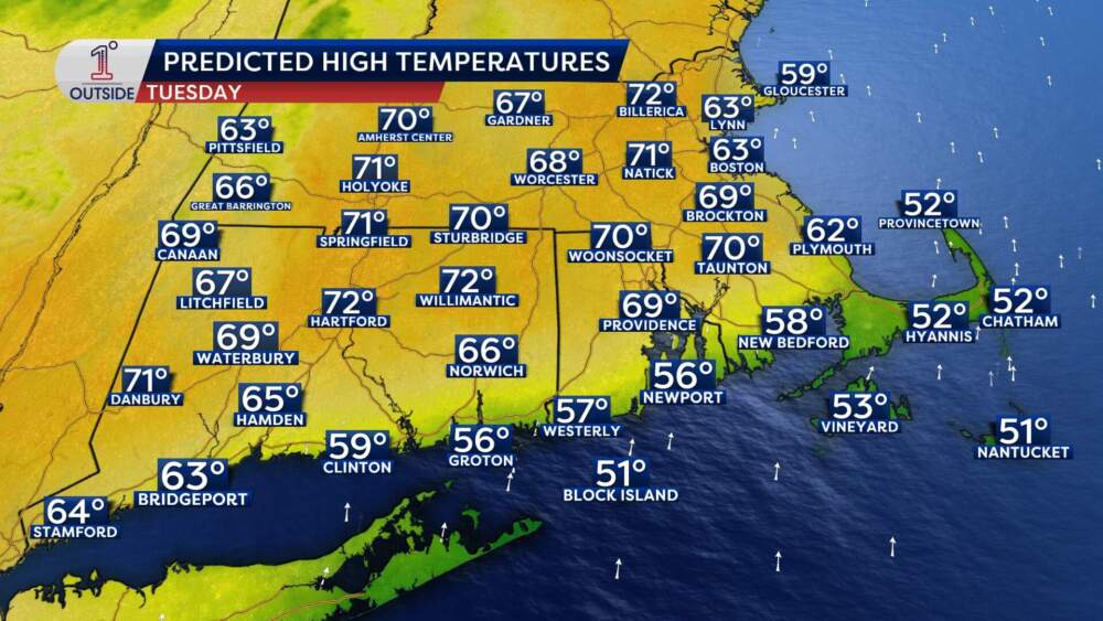
(Danielle Noyes/1DegreeOutside)
Tuesday will be even warmer, feeling like mid-May, not early March.
- Worcester: The record to beat is 67 degrees, set in 2020. There is a very high probability Worcester will shatter that, as some inland spots will make a run for 70 degrees.
- Boston: The record is a tougher at 71 degrees, set it 1878. While Boston will likely fall just short of that historic mark, it’s still going to be a beauty.
The average date for the first 70-degree day in Boston is April 7. Last year, Boston didn’t hit the 70s until April 19. If temperatures get there on Tuesday, it’s nearly a month ahead of schedule. It has been 152 days since Boston last saw 70 degrees, so soak it in.
The melting point: Ice jams and river rises
While New Englanders revel the warmth, the regions rivers are having a much more stressful week. This rapid warm-up is doing a number on the significant snowpack and river ice built up over the winter.
In parts of central and northern New England, the sudden warmth is causing river ice to break up and “jam” at bends and bridges. This can lead to flash flooding as water backs up behind the ice. And with all that melting snow, watch for minor river flooding in spots by the middle and end of the week.
Don’t put away the shovel
Enjoy the rays while they’re here, because “winter” is still lurking in the shadows. Cold air in Eastern Canada is just waiting, ready to pour chilly air back into the region. Scattered showers are possible as early as Tuesday evening.
The temperatures will stay mild on Wednesday and Thursday, with highs in the 50s, but the wind will start to kick up. Any time there’s have a massive tug-of-war between warm and cold air, it creates wind. A chance of rain lasts through Wednesday, with precipitation likely on Thursday.
By Thursday night, that cold air wins the battle. As the system pulls away, Boston might actually see the rain flip over to a coating of snow. By Friday, we’re back in the low 40s, and next week looks even more “March-like” with highs struggling to get out of the 30s.
So bask in the spring vibes for now. Take the long lunch, go for a walk and enjoy the rare Match warmth — just keep the winter coat and the snow brush within arm’s reach.
Get the latest updates at 1DegreeOutside.com or on the free 1DegreeOutside mobile app.