A cool & mostly/partly sunny day across Nebraska! Highs will reach the upper 50s & low 60s with a variable NE breeze. Showers & T-storms will develop south of I-80 near midnight & move ENE through Saturday morning.
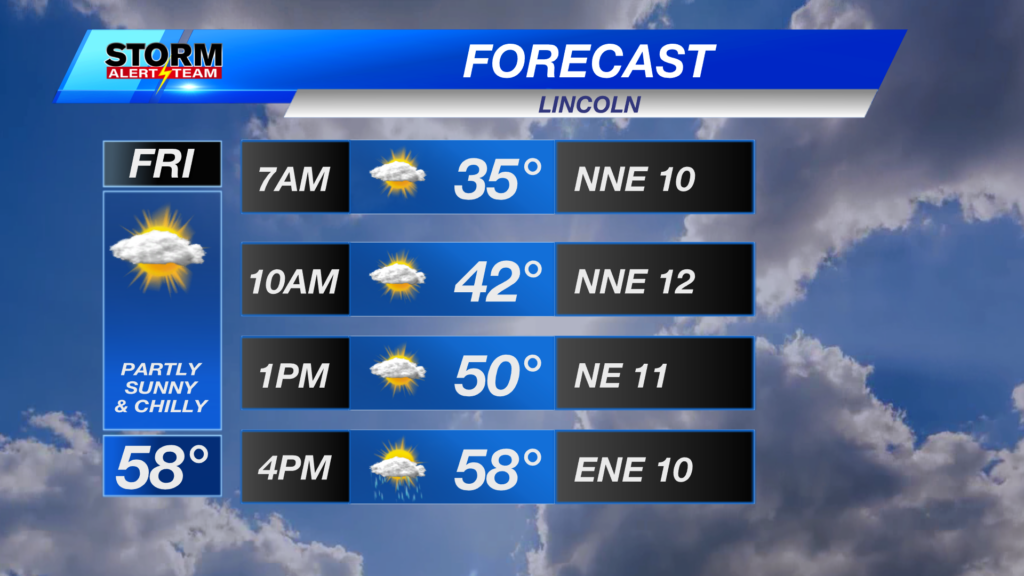
High temperatures this afternoon reaching the 50s & 60s! A few spots warmer due to more sunshine.
STORM TIMELINE Saturday: Near 1am Saturday, a few showers & T-storms will develop along the NE/KS border ahead of a warm front. Storms will move ENE through 7am carrying a small hail and wind threat.
By 2-4pm Saturday, areas north of I-80 could see a few strong to severe storms. This is if storms can break the CAP(limits lift). If storms break the CAP, they will have the best potential to grow fast & become severe.
There is a level 1 MARGINAL risk for severe weather for Saturday morning & evening. This is mainly due to the early morning storms south of I-80 and the potential for stronger storms by Saturday evening.
A LOT of moisture will move in Saturday afternoon across eastern Nebraska! It will feel muggy Saturday night through Sunday with dew points in the 60s & even 70s. This will also help fuel storms by the afternoon.
Saturday, showers & T-storms likely across eastern Nebraska. Sunday, rain will linger through the morning before diminishing Sunday afternoon. A strong system Monday evening brings more chances for storms into Tuesday. Keep an eye on the forecasts through this week!
Meteorologist Houston Hall
Facebook: HHallWX
YouTube: HHallWX
Tags: #klkntv, Beatrice, breezy, channel 8 weather, cool, forecast, Grand Island, hail, Hastings, hebron, lincoln, McCook, Nebraska, North Platte, Omaha, rain, severe weather, Spring, thunderstorms, tornado, warm, weather, Wind