INDIANAPOLIS (WISH) — Central Indiana starts Tuesday on a very cold note, but a dramatic warm-up is on the way later this week.
Snow showers ending this morning
A few lingering snow showers are moving across Central Indiana early this morning, but these will gradually end by mid-morning. Additional snow accumulations are not expected, as most of these snow showers are relatively light. That said, there is still snow on the ground from Monday evening, so slick spots will be possible for the drive into work this morning.
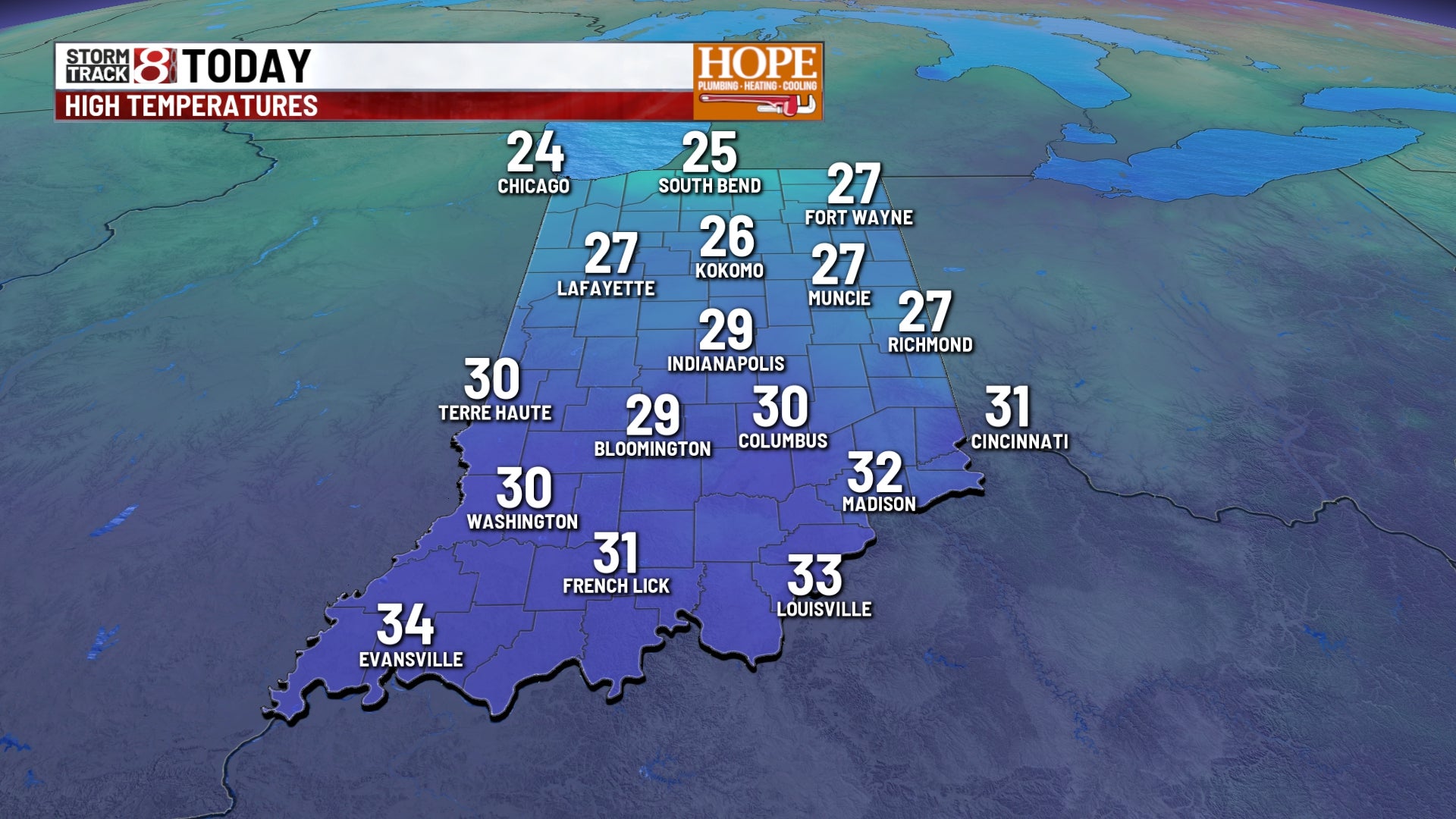
Temperatures will remain well below average for our St. Patrick’s Day.
High temperatures will only reach the upper 20s and lower 30s, which could end up being one of the coldest St. Patrick’s Days we’ve had in a long time. If we fail to hit the 30° mark, it will be the coldest March 17 high temperature since 1941.
In addition, wind chills are brutally cold this morning for this time of year, ranging from the single digits to near 0° as we start the day.
Light snow returns tonight.
A relatively weak system will slide in from the north and west late tonight through Wednesday morning, bringing light snow showers to the area. Most areas can expect up to an inch of snowfall, with a few spots seeing slightly higher amounts. Much of the snow will fall during the overnight hours or just before daybreak, leading to a slick Wednesday morning commute.
Warmer temperatures arrive Wednesday.
Any lingering snow Wednesday morning will quickly end, and warmer conditions will move into the region. Temperatures will rebound into the 40s and possibly even the low 50s, which will rapidly melt any snow that accumulated during the early morning hours.
Spring-like warmth by late week.
The biggest weather story will be the rapid warm-up heading into the end of the week. A large ridge of high pressure will settle in, allowing temperatures to climb well above average levels. This will begin Thursday. Despite increasing clouds and even a slight chance of rain, high temperatures should reach around 60° Thursday afternoon. Highs will climb toward the upper 60s and lower 70s on Friday, and Saturday should produce highs well into the 70s for many locations. Temperatures will remain very warm to close out the weekend on Sunday, with highs in the mid-60s before a cold front moves through, allowing numbers to fall back to the 50s early next week.