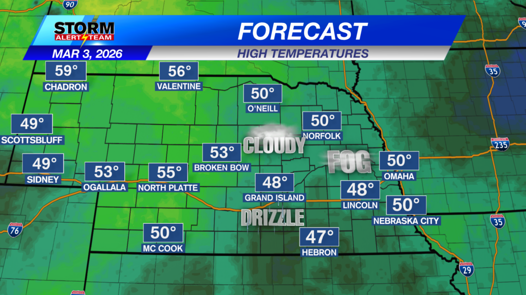
Today expect dense fog & light drizzle through noon. A small chance for a rain shower in SE Nebraska near 4-7pm. Temperatures will be warmer in the 50s & 60s statewide under mostly cloudy skies & light winds. Sunshine will be present farther west again…
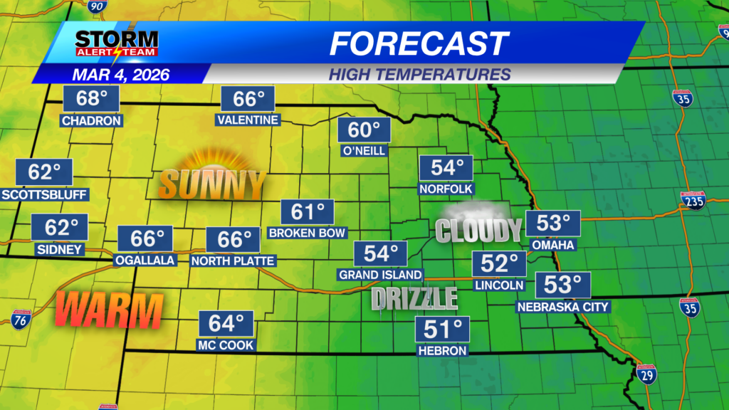
If the sun comes out this afternoon, a light rain shower or two is possible south of I-80 near 5-8pm.
Severe Weather Timeline Friday:
- 1:00 AM:
Scattered thunderstorms develop across southeast Nebraska and near Broken Bow. - 4:00–7:00 AM:
Storms continue through the morning hours across southeast Nebraska. - 1:00–4:00 PM:
Additional storms form farther west, with a possible wintry mix embedded within the precipitation. - 5:00–11:00 PM:
The severe threat increases across southeast Nebraska. A developing line of storms may produce large hail and damaging wind gusts in excess of 60 mph.
Late Thursday, a level 1 MARGINAL risk is in place for much of eastern Nebraska. A few storms could produce gusty winds up to 60+ mph & quarter size hail. There will also be frequent lightning with these showers and T-storms.
Friday morning and evening, a level 2 SLIGHT risk is in place for far SE Nebraska. This will be due to the storms Friday evening along the frontal boundary. These storms could produce slightly larger hail and winds up to 65+ mph.
Rain potential through Saturday morning looks very beneficial!! Much of us will see rain totals up to 0.25″+, with some spots seeing more rain especially if you get under a thunderstorm or two!
Snow accumulations through Saturday will stay across the panhandle. Colder air will settle longer farther west as the cold front pushes east Friday night.
Wednesday, expect DENSE FOG & patchy drizzle through noon. Small rain chance from 4-9pm. Thursday into Friday, temperatures really warm up bringing increasing moisture. Thursday evening through Friday, rain and storms will be LIKELY with a few severe storms carrying large hail & damaging winds. The weekend finally looks enjoyable!! Next week, temperatures could cool down due to a storm system Tuesday evening.
Meteorologist Houston Hall
Facebook: HHallWX
YouTube: HHallWX
Tags: #klkntv, Beatrice, breezy, channel 8 weather, cool, dense fog advisory, fog, forecast, Grand Island, hail, Hastings, lincoln, McCook, Nebraska, North Platte, Omaha, rain, severe weather, Spring, thunderstom, warm, weather, Wind