
As the Upper Peninsula and part of Northern Michigan is on the countdown to heavy snow and expected blizzard conditions starting tonight, daytime temperatures are ticking higher across the southern swath of the Lower Peninsula.
An all-day rain is forecast here, from Holland to Grand Rapids and Kalamazoo, and stretching across to Lansing, Ann Arbor, Flint and Detroit.
While temperatures are staying colder in the northern half of the state, areas from Holland to Detroit could see high temperatures hit the spring-like 50s today amid all this rain.
But there are some twists with today’s heavy rainfall, which could add up to an inch or two in some areas by tonight.
There were some pockets of freezing rain and drizzle today along the northern edge of this rain mass. Mid-Michigan areas like Big Rapids, Clare and Mount Pleasant saw roads ice up.
And later today, thunderstorms are expected – some could even be borderline severe this afternoon and tonight near the Ohio border.
“Morning forecast update includes the expansion of a Marginal Risk for severe weather into Lenawee and Monroe counties,” the National Weather Service meteorologists in the Detroit office said today. “Strong to borderline severe thunderstorms will be possible here, with wind gusts in excess of 40 mph as the main threat.”
The time to expect the heaviest rainfall is this afternoon and into the evening.
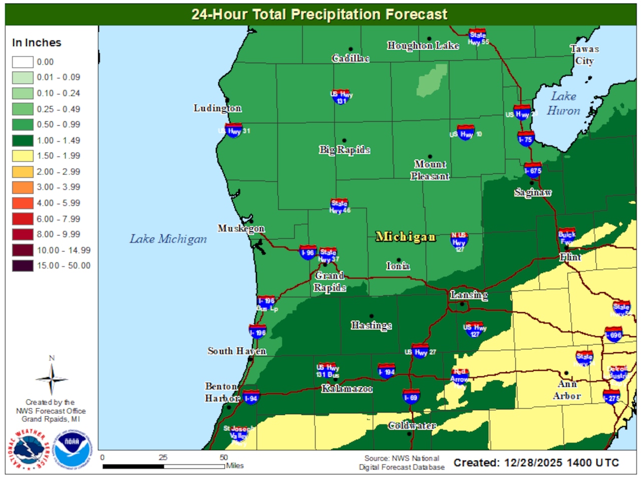
Here is the 24-hour total precipitation forecast for the Lower Peninsula:
Here’s how much rain and other precipitation could fall across the Lower Peninsula from Sunday into Monday.Graphic provided by the National Weather Service
And tonight is when the high winds in this incoming storm system really kick in. High Wind Watches have been issued across the state, with wind gusts topping 60 mph expected in some areas. Sustained winds could reach 35 mph. This could lead to tree damage and scattered power outages, too.
Gale and Storm-force winds are expected on the Great Lakes, which could lead to massive waves.
By Monday, temperatures are forecast to plunge as an Arctic blast arrives and rain changes over to snow. The high winds plus the incoming snow could lead to snow squalls, which make driving hazardous.
To see the latest update on this storm coverage, follow our headlines on the MLive Weather page.


