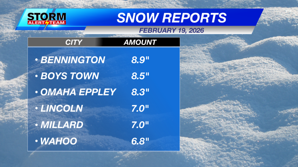
Thursday’s snowfall in Lincoln was one for the record books! The old daily snowfall record of 4.4″ (set in 2019) was crushed, as the city officially recorded more than 7 inches of snow, with some neighborhoods picking up even higher totals.
The narrow band of heaviest snow ultimately set up a bit farther south, leading to even bigger numbers in Omaha, where 8–9+ inches were reported
This afternoon, temperatures only reaching the 20s! Breezy NW winds 10-15 mph will occur through the early afternoon. Sunny skies will be present all day across Nebraska. Snow will have trouble melting, as fresh snow has a high reflectance rate. Snow will slowly melt as we go into Monday.
Northwest winds will gust to around 20-25 mph through noon before easing up. A blustery feel to your Friday.
Another round of light snow will attempt to push east from SW Nebraska Friday night (5pm-5am Saturday). This will be light, fluffy snow mainly across SW Nebraska as it drifts east overnight. A few locations near the Kansas/NE border could get around 0.5″ or more. Some light snow and flurries in south Lincoln by 10pm- midnight.
Here is the potential snow accumulations through Saturday morning:
Snow on the ground will keep us cold and blustery through the weekend. By Tuesday, temperatures warm back up into the 40s and 50s. Tracking a small chance for precipitation late Wednesday into Thursday March. Stay safe out there!
Meteorologist Houston Hall
Facebook: HHallWX
YouTube: HHallWX
Tags: #klkntv, Beatrice, channel 8 weather, cool, forecast, Grand Island, Hastings, lincoln, McCook, Nebraska, North Platte, Omaha, school cancellation, snow, weather, windy, Winter Storm