
This is AI generated summarization, which may have errors. For context, always refer to the full article.
Floods and landslides are expected as parts of the Philippines face rainy days in the final week of November
MANILA, Philippines – Some regions and provinces in Mindanao, the Visayas, and Luzon are bracing for significant rain from the low pressure area (LPA) inside the Philippine Area of Responsibility and the shear line.
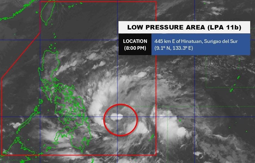
The Philippine Atmospheric, Geophysical, and Astronomical Services Administration (PAGASA) said the LPA was last spotted 445 kilometers east of Hinatuan, Surigao del Sur, at 8 pm on Sunday, November 23.
The LPA continues to have a high chance of developing into a tropical depression within 24 hours. If it becomes a tropical depression, it would be given the local name Verbena.
PAGASA Weather Specialist Grace Castañeda said the future Verbena could generally move west northwest, heading for northeastern Mindanao, the Visayas, and northern Palawan.
The regions of Caraga and Eastern Visayas, as well as parts of the Bicol region and the provinces of Bohol and Misamis Oriental, may be the first to get heavy rain.
Here is PAGASA’s updated rainfall outlook for the potential tropical cyclone, released at 11 pm on Sunday:
Sunday evening, November 23, to Monday evening, November 24
- Heavy to intense rain (100-200 millimeters): Eastern Samar, Surigao del Norte, Dinagat Islands
- Moderate to heavy rain (50-100 mm): Albay, Sorsogon, Northern Samar, Samar, Leyte, Biliran, Southern Leyte, Bohol, Agusan del Norte, Agusan del Sur, Surigao del Sur, Misamis Oriental
Monday evening, November 24, to Tuesday evening, November 25
- Heavy to intense rain (100-200 mm): Albay, Sorsogon, Masbate, Romblon, Oriental Mindoro, Southern Leyte, Leyte, Biliran, Cebu, Bohol, Negros Occidental, Capiz, Iloilo, Dinagat Islands
- Moderate to heavy rain (50-100 mm): Occidental Mindoro, Marinduque, Palawan, Catanduanes, Camarines Norte, Camarines Sur, Northern Samar, Samar, Eastern Samar, Negros Oriental, Siquijor, Antique, Aklan, Guimaras, Surigao del Norte, Surigao del Sur, Agusan del Norte, Agusan del Sur, Misamis Oriental, Camiguin, Bukidnon
Tuesday evening, November 25, to Wednesday evening, November 26
- Heavy to intense rain (100-200 mm): Aklan, Antique, Palawan, Occidental Mindoro, Oriental Mindoro
- Moderate to heavy rain (50-100 mm): Quirino, Nueva Vizcaya, Cavite, Batangas, Laguna, Camarines Sur, Camarines Norte, Catanduanes, Albay, Marinduque, Romblon, Capiz, Iloilo, Guimaras, Negros Occidental
Another source of rain is the shear line, or the point where cold air from the northeast monsoon or amihan converges with the easterlies or warm winds from the Pacific Ocean.
The shear line will still dump rain in several provinces on the eastern side of Luzon over the next 48 hours before bringing heavy rain to more areas, including Metro Manila.
Sunday evening, November 23, to Monday evening, November 24
- Moderate to heavy rain (50-100 mm): Cagayan, Isabela, Aurora, Quezon
Monday evening, November 24, to Tuesday evening, November 25
- Moderate to heavy rain (50-100 mm): Cagayan, Isabela, Apayao, Kalinga, Aurora, Quezon
Tuesday evening, November 25, to Wednesday evening, November 26
- Heavy to intense rain (100-200 mm): Isabela, Aurora, Quezon
- Moderate to heavy rain (50-100 mm): Metro Manila, Rizal, Nueva Ecija, Bulacan, Cagayan, Apayao, Kalinga, Mountain Province, Ifugao
Floods and landslides are likely in areas affected by the LPA and the shear line. PAGASA advised the public to be alert and to keep monitoring updates. – Rappler.com


![[Two Pronged] Struggling to recover from the holiday blues](https://conven.org/wp-content/uploads/2025/12/Two-Pronged-Struggling-to-recover-from-the-holiday-blues.jpg)
