This is AI generated summarization, which may have errors. For context, always refer to the full article.
Moderate to heavy rain is still expected from Tropical Depression Mirasol, while Tropical Depression Nando is not yet directly affecting weather in the Philippines
MANILA, Philippines – Tropical Depression Mirasol left the landmass of Northern Luzon on Wednesday evening, September 17, as another tropical depression entered the Philippine Area of Responsibility (PAR) and was given the local name Nando.
Mirasol
As of 10 pm on Wednesday, Mirasol was already over the coastal waters of Pagudpud, Ilocos Norte, moving north northwest at only 10 kilometers per hour (km/h).
It had made landfall in Casiguran, Aurora, at 3:20 am, then crossed Northern Luzon.
The Philippine Atmospheric, Geophysical, and Astronomical Services Administration (PAGASA) said the tropical depression still has maximum sustained winds of 55 km/h, while its gustiness is up to 75 km/h. But it could intensify into a tropical storm early Thursday morning, September 18.
Though Mirasol has left land, it may still cause moderate to heavy rain (50-100 millimeters) in Cagayan, Isabela, Kalinga, Apayao, Abra, Ilocos Norte, and Ilocos Sur on Thursday.
The tropical depression also continues to bring strong winds to these areas which remain under Signal No. 1 as of 11 pm on Wednesday:
- Batanes
- Cagayan including Babuyan Islands
- northern part of Isabela (Santo Tomas, Santa Maria, Quezon, Roxas, Delfin Albano, San Pablo, Tumauini, Cabagan, Quirino, Mallig, Maconacon, San Mateo, Aurora, Cabatuan, San Manuel, Burgos, Gamu, Reina Mercedes, Luna, Ilagan City, Divilacan)
- Apayao
- Abra
- Kalinga
- Mountain Province
- eastern and northern parts of Ifugao (Mayoyao, Hungduan, Aguinaldo, Banaue, Alfonso Lista, Hingyon)
- Ilocos Norte
- northern and central parts of Ilocos Sur (Sinait, Cabugao, San Juan, Magsingal, Santo Domingo, Bantay, San Vicente, San Ildefonso, Santa Catalina, Vigan City, Caoayan, Santa, Cervantes, Quirino, San Emilio, Gregorio del Pilar, San Esteban, Banayoyo, Burgos, Candon City, Santa Lucia, Santiago, Lidlidda, Nagbukel, Suyo, Sigay, Galimuyod, Santa Cruz, Santa Maria, Narvacan, Salcedo)
The highest possible tropical cyclone wind signal due to Mirasol is Signal No. 2.
On Thursday, moderate to rough seas are likely in the western seaboards of Batanes and Babuyan Islands (waves up to 2.5 meters high), as well as the remaining seaboards of Batanes and Babuyan Islands, and the seaboards of mainland Cagayan, Isabela, Ilocos Norte, and Ilocos Sur (waves up to 2 meters high).
PAGASA advised small vessels to take precautionary measures or avoid sailing, if possible.
Mirasol is set to leave PAR on Thursday morning.
Nando
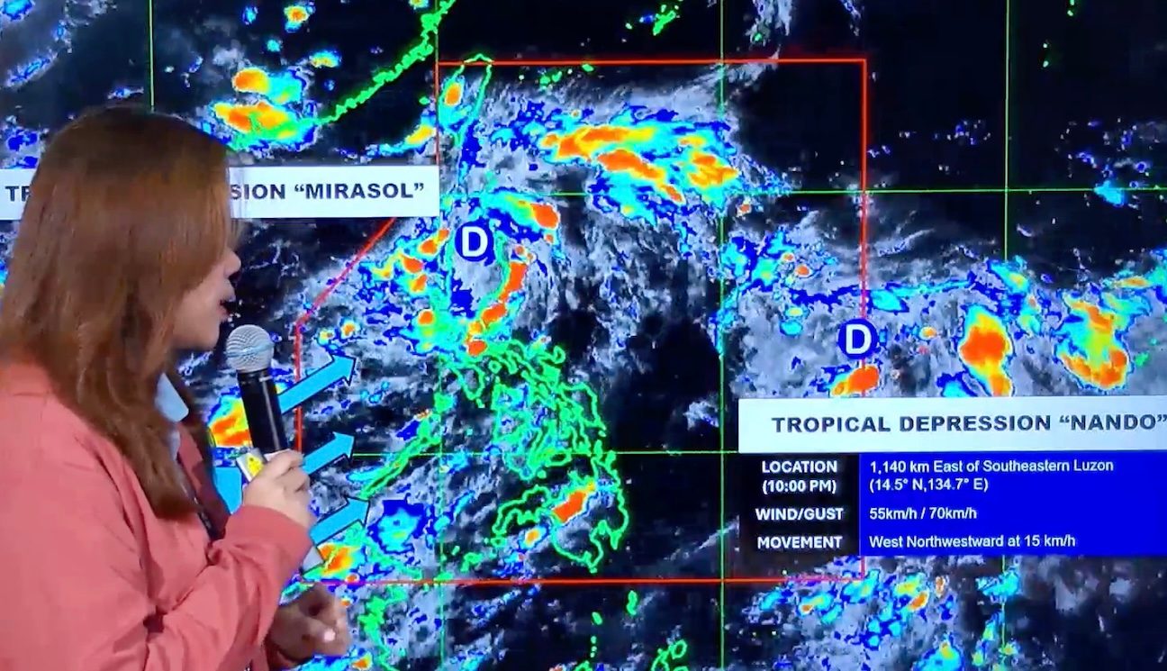
Meanwhile, Tropical Depression Nando was located 1,140 kilometers east of southeastern Luzon at 10 pm on Wednesday.
It is moving west northwest at 15 km/h, with maximum sustained winds of 55 km/h and gustiness of up to 70 km/h.
PAGASA said Nando “is less likely to directly affect the weather” in the next 48 hours. But it warned the public that this tropical cyclone is expected to affect the country beyond that period, and possibly enhance the southwest monsoon or habagat as it heads for extreme Northern Luzon.
Nando and the southwest monsoon might trigger heavy rain starting Sunday, September 21, or Monday, September 22.
Signal No. 1 may be raised in Northern Luzon as early as Saturday, September 20, to give areas sufficient time to prepare for winds from Nando.
Also by Saturday, Nando could already be a typhoon. “Further intensification into super typhoon category is not ruled out,” added PAGASA.
If Nando does become a super typhoon, the highest possible tropical cyclone wind signal would be Signal No. 5.
Mirasol and Nando are the Philippines’ 13th and 14th tropical cyclones, respectively, for 2025. They also bring to four the number of tropical cyclones in September — the upper end of PAGASA’s estimated range for the month.
ALSO ON RAPPLER
Southwest monsoon
PAGASA also said that parts of Luzon, Western Visayas, the Negros Island Region, and the Zamboanga Peninsula may currently have scattered rain and thunderstorms due to the southwest monsoon.
The southwest monsoon is bringing strong to gale-force gusts to these areas as well:
Thursday, September 18
- Metro Manila, Isabela, Cagayan including Babuyan Islands, Batanes, Ilocos Region, Zambales, Bataan, Cavite, Quezon, Bicol, Mimaropa, Western Visayas
Friday, September 19
- Ilocos Region, Zambales, Bataan
– Rappler.com