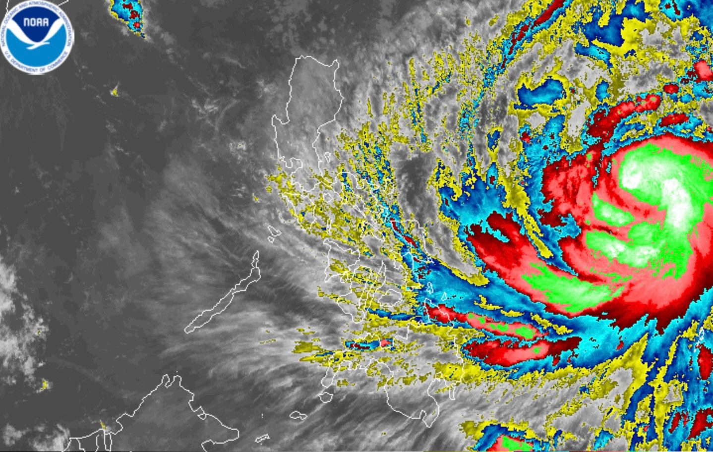
Catanduanes and portions of Samar Island are under Signal No. 2 due to Typhoon Uwan (Fung-wong) as of 5 am on Saturday, November 8
MANILA, Philippines – The weather bureau raised Signal No. 2 due to Typhoon Uwan (Fung-wong) for the first time at 5 am on Saturday, November 8, as the tropical cyclone further strengthened offshore.
Uwan’s maximum sustained winds increased from 120 kilometers per hour to 130 km/h, said the Philippine Atmospheric, Geophysical, and Astronomical Services Administration (PAGASA) in its 5 am bulletin on Saturday. The typhoon’s gustiness is now up to 160 km/h from 150 km/h.
It is still projected to strengthen into a super typhoon on Saturday evening or Sunday morning, November 9. Under PAGASA’s classification, a super typhoon has maximum sustained winds of 185 km/h or above.
Uwan was last spotted 985 kilometers east of Eastern Visayas at 4 am on Saturday, moving west northwest at a slightly faster 25 km/h from 20 km/h.
These are the areas under tropical cyclone wind signals as of 5 am, with more areas also added under Signal No. 1, including Metro Manila:
Signal No. 2
Gale-force winds (62 to 88 km/h), minor to moderate threat to life and property
- Catanduanes
- eastern and central parts of Northern Samar (Lope de Vega, Palapag, Las Navas, Mapanas, Laoang, Catubig, Mondragon, Lapinig, Pambujan, Catarman, San Roque, Silvino Lobos, Gamay)
- northeastern part of Samar (Matuguinao, San Jose de Buan)
- northern part of Eastern Samar (Maslog, San Policarpo, Dolores, Jipapad, Oras, Arteche)
Signal No. 1
Strong winds (39 to 61 km/h), minimal to minor threat to life and property
- Cagayan including Babuyan Islands
- Isabela
- Quirino
- Nueva Vizcaya
- Apayao
- Abra
- Kalinga
- Mountain Province
- Ifugao
- Benguet
- Ilocos Norte
- Ilocos Sur
- La Union
- Pangasinan
- Aurora
- Nueva Ecija
- Bulacan
- Tarlac
- Pampanga
- Zambales
- Bataan
- Metro Manila
- Cavite
- Laguna
- Batangas
- Rizal
- Quezon including Polillo Island
- Camarines Norte
- Camarines Su
- Albay
- Sorsogon
- Masbate including Ticao Island and Burias Island
- Marinduque
- Romblon
- Oriental Mindoro
- Occidental Mindoro including Lubang Islands
- Calamian Islands
- rest of Northern Samar
- rest of Samar
- rest of Eastern Samar
- Biliran
- Leyte
- Southern Leyte
- northeastern part of Bohol (Getafe, Talibon, Buenavista, Trinidad, San Miguel, Ubay, Alicia, Mabini, Bien Unido, President Carlos P. Garcia)
- northern and central parts of Cebu (Medellin, Daanbantayan, Bogo City, Tabogon, San Remigio, Tabuelan, Borbon, Sogod, Tuburan, Catmon, Carmen, Danao City, Compostela, Liloan, Consolacion, Lapu-Lapu City, Mandaue City, Cordova, Asturias, Cebu City, Balamban, Talisay City, Toledo City, Minglanilla) including Bantayan and Camotes Islands
- northern part of Negros Occidental (Escalante City, Toboso, Sagay City, Cadiz City, Calatrava, Manapla, Victorias City, Enrique B. Magalona, Silay City, Talisay City, San Carlos City, Salvador Benedicto, Murcia, Bacolod City)
- northern and central parts of Iloilo (Carles, Estancia, Balasan, San Dionisio, Concepcion, Batad, Sara, Ajuy, Barotac Viejo, San Rafael, Lemery, Lambunao, Calinog, Bingawan, Passi City, San Enrique, Anilao, Banate, Dingle, Dueñas, Janiuay, Badiangan, Mina, Pototan, Barotac Nuevo, Dumangas)
- Capiz
- Aklan
- northern and central parts of Antique (Pandan, Libertad, Sebaste, Culasi, Valderrama, Tibiao, Barbaza, Laua-an, Bugasong) including Caluya Islands
- Dinagat Islands
- Surigao del Norte
The highest tropical cyclone wind signal likely to be raised due to Uwan is Signal No. 5.
Uwan may also bring occasional gusts even to areas not under wind signals here:
Saturday, November 8, and Monday, November 9
- Palawan, Visayas, Mindanao
Monday, November 10
Eastern Samar, Northern Samar, and Catanduanes would be the first provinces seeing significant rain from the typhoon on Saturday, although Uwan may already trigger rain with gusty winds in the rest of Eastern Visayas, Central Visayas, the rest of Bicol, Isabela, Aurora, Quezon, Dinagat Islands, and Surigao del Norte, as well as scattered rain and thunderstorms in the rest of the country except Batanes.
Batanes will have moderate to at times heavy rain on Saturday, but due to the northeast monsoon or amihan.
Below is PAGASA’s updated rainfall outlook for Uwan, covering the next three days.
Saturday, November 8
- Moderate to heavy rain (50-100 millimeters): Eastern Samar, Northern Samar, Catanduanes
Sunday, November 9
- Intense to torrential rain (above 200 mm): Camarines Norte, Camarines Sur, Catanduanes, Albay, Aurora
- Heavy to intense rain (100-200 mm): Cagayan, Isabela, Quirino, Nueva Vizcaya, Quezon, Sorsogon, Masbate, Northern Samar, Eastern Samar
- Moderate to heavy rain (50-100 mm): Apayao, Kalinga, Mountain Province, Ifugao, Abra, Benguet, Ilocos Norte, Ilocos Sur, La Union, Pangasinan, Nueva Ecija, Tarlac, Pampanga, Bulacan, Zambales, Bataan, Metro Manila, Cavite, Rizal, Laguna, Batangas, Marinduque, Oriental Mindoro, Occidental Mindoro, Romblon, Biliran, Samar
Monday, November 10
- Intense to torrential rain (above 200 mm): Aurora, Nueva Ecija, Cagayan, Isabela, Quirino, Nueva Vizcaya, Apayao, Kalinga, Abra, Mountain Province, Ifugao, Benguet, Ilocos Norte, Ilocos Sur, La Union, Zambales, Tarlac, Pangasinan
- Heavy to intense rain (100-200 mm): Metro Manila, Bataan, Pampanga, Bulacan, Cavite, Laguna, Batangas, Rizal, Quezon, Occidental Mindoro
- Moderate to heavy rain (50-100 mm): Batanes, Oriental Mindoro, Marinduque, Romblon, Camarines Norte, Camarines Sur
Widespread floods and landslides are expected.
In addition, there is a high risk of “life-threatening and damaging” storm surges with peak heights exceeding 3 meters in Isabela, Aurora, Quezon including Polillo Islands, Camarines Norte, Camarines Sur, Catanduanes, Albay, Sorsogon, Northern Samar, and Eastern Samar within 48 hours. Check the specific cities and municipalities here.
Uwan is still seen to make landfall in the southern portion of Isabela or the northern portion of Aurora late Sunday evening or early Monday morning, November 10, while at or near its peak intensity.
“After landfall, Uwan will traverse the mountainous terrain of Northern Luzon and emerge over the West Philippine Sea on Monday morning or afternoon,” PAGASA said.
The weather bureau added that Uwan may weaken as it hits land, but it is likely to remain a typhoon while crossing Northern Luzon and the West Philippine Sea.
On Saturday, sea conditions are beginning to worsen, with up to very high seas already expected.
Up to very rough, high, or very high seas (travel is risky for all vessels)
- Northern and eastern seaboards of Catanduanes; eastern seaboard of Camarines Sur – waves up to 14 meters high
- Eastern seaboards of Camarines Norte, Albay, and Sorsogon; northern seaboard of Northern Samar – waves up to 10 meters high
- Eastern seaboards of Cagayan, Isabela, and Northern Samar; seaboards of Aurora and northern mainland Quezon; northern and eastern seaboards of Polillo Islands – waves up to 8 meters high
- Eastern seaboard of Eastern Samar – waves up to 7 meters high
- Seaboards of Batanes and Babuyan Islands; northern seaboard of mainland Cagayan – waves up to 6 meters high
- Seaboards of Siargao Island and Bucas Grande Island, and Dinagat Islands – waves up to 4.5 meters high
Up to rough seas (small vessels should not venture out to sea)
- Eastern seaboards of Surigao del Sur and Davao Oriental – waves up to 4 meters high
- Seaboards of Ilocos Norte, Ilocos Sur, La Union, Pangasinan, and Zambales; western seaboard of Bataan; remaining seaboards of Catanduanes; eastern seaboard of Davao Occidental – waves up to 3.5 meters high
- Remaining seaboards of Sorsogon, Albay, Camarines Norte, and Ticao Island and Burias Island; eastern seaboard of Masbate – waves up to 3 meters high
Up to moderate to rough seas (small vessels should take precautionary measures or avoid sailing, if possible)
- Southern seaboard of Samar; eastern seaboards of Leyte and Southern Leyte; remaining seaboard of Eastern Samar – waves up to 2.5 meters high
- Seaboards of Marinduque, Kalayaan Islands, Antique, Biliran, Zamboanga del Norte, and Sarangani; western seaboards of Lubang Islands and Calamian Islands; western and southern seaboards of Negros Oriental; southwestern seaboard of Negros Occidental; northern seaboard of Leyte; northern and eastern seaboards of Romblon; remaining seaboards of Bicol, Quezon, Northern Samar, Samar, and Caraga – waves up to 2 meters high
Uwan is the Philippines’ 21st tropical cyclone for 2025, and the second for November. It entered the Philippine Area of Responsibility (PAR) at 10 pm on Friday, November 7, less than 48 hours after the exit of Typhoon Tino (Kalmaegi), which is the country’s deadliest tropical cyclone this year, so far.
PAGASA expects two or three tropical cyclones to form within or enter PAR in November. – Rappler.com