
This is AI generated summarization, which may have errors. For context, always refer to the full article.
Portions of Northern Luzon and the northern part of Zambales remain under Signal No. 1 even after the exit of Severe Tropical Storm Paolo (Matmo) from the Philippine Area of Responsibility early Saturday, October 4
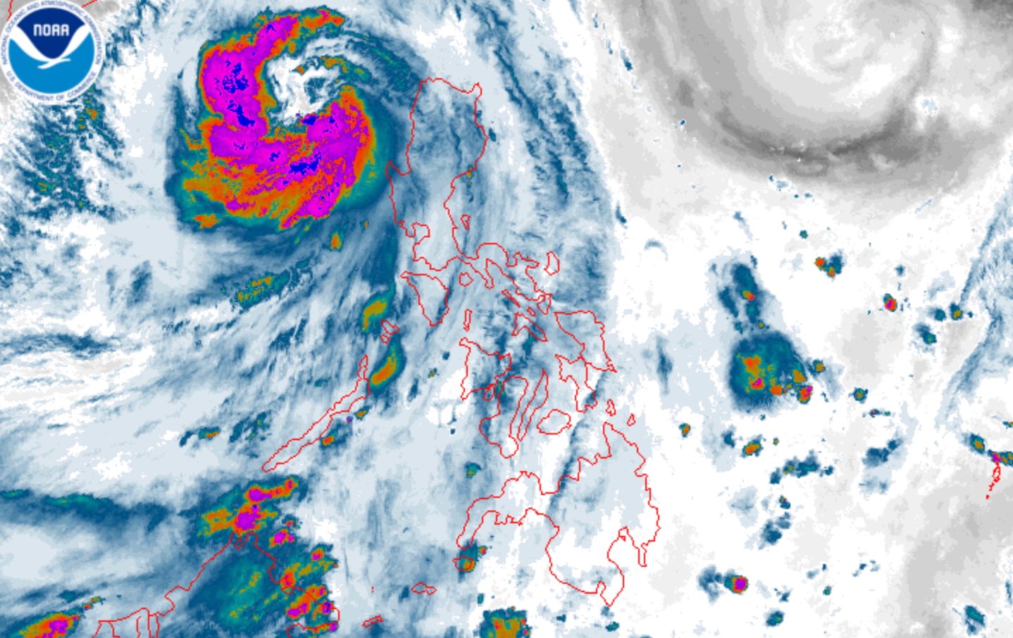
MANILA, Philippines – Severe Tropical Storm Paolo (Matmo) left the Philippine Area of Responsibility (PAR) before dawn on Saturday, October 4, although portions of Luzon are still under Signal No. 1 due to the size of the tropical cyclone.
In a briefing past 5 am on Saturday, the Philippine Atmospheric, Geophysical, and Astronomical Services Administration (PAGASA) said Paolo was already 295 kilometers west of Sinait, Ilocos Sur, at 4 am.
The severe tropical storm slowed down further, moving west northwest toward China at 20 kilometers per hour from 25 km/h.
It continues to have maximum sustained winds of 110 km/h and gustiness of up to 135 km/h. But PAGASA expects Paolo to re-intensify into a typhoon over the West Philippine Sea on Saturday morning or afternoon.
At its peak, Paolo was a typhoon with maximum sustained winds of 130 km/h. It was at this intensity when it made landfall in Dinapigue, Isabela, at 9 am on Friday, October 3, bringing torrential rain and damaging winds to areas in its path.
Paolo was subsequently downgraded to a severe tropical storm late Friday afternoon after it crossed the mountainous region of Northern Luzon.
The following areas remain under Signal No. 1 as of 5 am on Saturday, which means they still have strong winds due to Paolo:
- western part of Abra (Danglas, Bangued, Langiden, San Quintin, Pidigan, San Isidro, Pilar, Villaviciosa, Peñarrubia, Manabo, Luba, Tayum, La Paz, Lagayan, Tubo, Bucay, Dolores, San Juan, Lagangilang)
- western part of Benguet (Bakun, Kibungan, Kapangan, Sablan, Tuba, Mankayan, Tublay, La Trinidad, Baguio City)
- southern part of Ilocos Norte (Nueva Era, Banna, Badoc, Pinili, Batac City, Paoay, Marcos, Currimao)
- Ilocos Sur
- La Union
- western and central parts of Pangasinan (Bolinao, Bani, Agno, Burgos, Dasol, Mabini, Infanta, Bugallon, Labrador, Sual, Alaminos City, Lingayen, Aguilar, Mangatarem, Urbiztondo, San Carlos City, Binmaley, Dagupan City, Calasiao, Basista, Bayambang, San Fabian, San Jacinto, Mangaldan, Mapandan, Santa Barbara, Malasiqui, Alcala, Bautista, Santo Tomas, Villasis, Urdaneta City, Manaoag, Laoac, Pozorrubio, Sison)
- northern part of Zambales (Iba, Candelaria, Palauig, Santa Cruz, Masinloc)
The highest tropical cyclone wind signal raised due to Paolo was Signal No. 4.
PAGASA added that the outer bands of the severe tropical storm may still bring strong to gale-force gusts to Batanes, the northern part of mainland Cagayan including Babuyan Islands, Apayao, the rest of Zambales, and Bataan on Saturday.
The weather bureau’s forecast shows Paolo is now “less likely” to trigger significant rainfall after its exit from PAR. But its trough or extension may still cause scattered rain and thunderstorms in the Ilocos Region, Cordillera Administrative Region, Central Luzon, Metro Manila, Cavite, Batangas, and Occidental Mindoro on Saturday.
In addition, there is still a minimal to moderate risk of storm surges with peak heights reaching 1 to 2 meters in Ilocos Norte, Ilocos Sur, La Union, Pangasinan, and Zambales within 12 hours. Check the specific cities and municipalities here.
Moderate to rough seas will persist in these seaboards on Saturday as well:
- Seaboards of mainland Cagayan, Babuyan Islands, Ilocos Norte, Ilocos Sur, and La Union – waves up to 4 meters high
- Seaboards of Batanes and Pangasinan – waves up to 3.5 meters high
- Seaboards of Isabela, northern Aurora, and Zambales – waves up to 2.5 meters high
- Remaining seaboards of Aurora; western seaboard of Bataan; seaboards of Lubang Island – waves up to 2 meters high
ALSO ON RAPPLER
Paolo was the country’s 16th tropical cyclone for 2025, and the first for October. During the month, two to four tropical cyclones are estimated to form within or enter PAR.
Just as Paolo exited, PAGASA spotted a new low pressure area (LPA) outside PAR, located 2,320 kilometers east of extreme Northern Luzon as of 3 am on Saturday.
It has a medium chance of developing into a tropical depression within 24 hours.
PAGASA Weather Specialist Grace Castañeda said the LPA or potential tropical cyclone might enter PAR by Monday night, October 6, or Tuesday morning, October 7. But it could just stay offshore near the PAR northern boundary and would be less likely to affect the country, added Castañeda.
The weather bureau still advised the public to keep monitoring updates on the LPA as forecasts can change. – Rappler.com


