Delhi was burning hot. The hills were meant to be the escape.
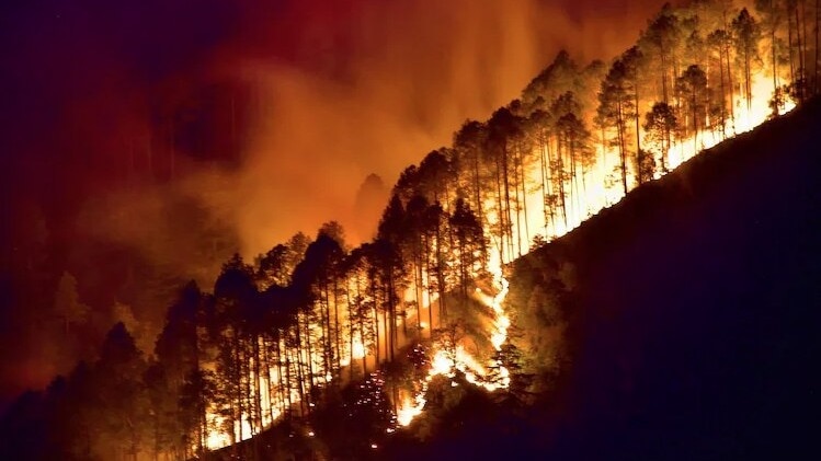
But for many who drove up to Kasauli in Himachal or Pauri in Uttarakhand over the weekend, the cool mountain air came with a frightening view: forests on fire, smoke rising from slopes, and long patches of green turning black.
Visuals on social media were filled with shocking scenes: hillsides on fire, roads choked with smoke, and forests glowing in the dark.
India Today’s OSINT team detected multiple forest fires near Almora, Pauri and Nainital in Uttarakhand, and near Shimla and Kinnaur in Himachal Pradesh.
Uttarakhand recorded 476 forest fire incidents between February 15 and May 29, 2026, affecting 402.38 hectares of forest land. Of this, Garhwal accounted for 357 incidents and 306.88 hectares, Kumaon for 83 incidents and 69.25 hectares, and administrative/wildlife areas for 36 incidents and 26.25 hectares, according to the Uttarakhand Forest Department.
For Himachal, the number sits at 295 forest fire incidents so far this year, including 288 in summer and 7 in winter, according to the Himachal Pradesh Forest Department’s FIRE dashboard.
Using a custom wildfire visualisation script developed by remote-sensing specialist Pierre Markuse on Sentinel-2 satellite imagery, India Today identified large stretches of forest land that had been charred by fire.
A forested area near Almora in Uttarakhand, spread across nearly 4 km square or roughly 400 hectares, appeared scorched in the Sentinel imagery, its vegetation stripped away and the landscape marked by black burn scars.
A similar pattern was seen near Pauri, where large patches of vegetation appeared to have turned black after forest fires swept through the area.
Uttarakhand’s forest fires are often driven by a dangerous mix of dry pine needles, rising temperatures and human activity, including deliberate burning to clear land or encourage fresh grass growth. Satellite data also showed multiple active fire zones in forested areas of Chamoli and Rudraprayag districts.
According to experts, heatwaves and dry winds are only part of the story. The forests themselves can act like fuel. Large parts of the lower Himalayan belt in Uttarakhand and Himachal Pradesh are dominated by Chir pine, or Pinus roxburghii. Unlike oak or deodar forests, Chir pine forests are highly combustible: their dry needles carpet the forest floor, catch fire easily and help flames spread fast.
A recent CSIR-Institute of Himalayan Bioresource Technology study reportedly found that Chir pine forests account for nearly 57% of forest fire incidents in the western Himalayas.
Every summer, Chir pine trees shed large volumes of dry needles, locally known as pirul. Rich in resin, these needles are highly flammable. Once they collect in thick layers on the forest floor, even a small spark, from a cigarette butt, roadside fire or deliberate burning, can quickly spread into a wildfire.
– Ends
Published By:
Ritaban Misra
Published On:
May 30, 2026 18:58 IST