Along the Vaigai river in southern Tamil Nadu, archaeologists have been excavating an old settlement at Keezhadi. They have already found brick walls, channels that look like drains or small canals, floors made of fine clay, and many pieces of pottery. These finds matter because Tamil poems from the Sangam period talk about busy towns and trade in this region but the poems don’t give firm dates. To connect the stories, the structures, and the river’s history, researchers need a reliable timeline for when different layers of sediment were laid down and when the buildings were buried.
A recent study by researchers from Physical Research Laboratory in Ahmedabad and the Department of Archaeology of Tamil Nadu has now reported when flood sediments covered the Keezhadi structures. The authors focused on the fact that Keezhadi, which is in Sivaganga district, sits on a mound on the Vaigai floodplain and that the buildings are not exposed at the surface. Instead, they lie under layers of sand, silt, and clay that the river likely deposited when it flooded. If the team could date the burial sediments, they figured, they’d be able to estimate when the settlement was damaged or abandoned and then covered up.
Telling time with light
To do this, the team used a method called optically stimulated luminescence (OSL) dating. The basic idea is simple even if the lab work is not. Small grains of minerals, especially quartz, sit in the ground and slowly collect energy from natural radiation in the surrounding sediment. Sunlight ‘resets’ this stored energy when the grains are exposed at the surface. Later, if the grains are buried and kept away from light, they start storing energy again. In an OSL lab, scientists stimulate the grains with light and measure the glow (or luminescence) they give off. That glow helps estimate how long it has been since the grains last saw sunlight, which is usually close to the time they were buried by new sediment.
The team collected four sediment samples from two excavation pits at Keezhadi, called KDI-1 and KDI-2, each from a different depth and layer. They hammered light-tight metal tubes horizontally into the sediment so that sunlight couldn’t reach the grains. In the laboratory, they opened the tubes under red light, removed the outer part that might have been exposed during collection, and kept the inner part for the actual dating measurements. Then they cleaned and separated quartz grains using chemical and magnetic methods designed to remove other minerals and contamination.
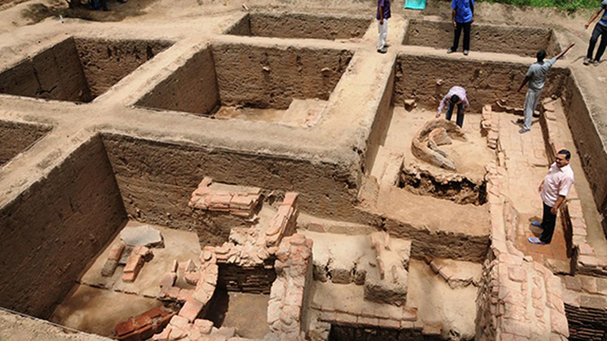
The different litho-stratigraphic layers at the Keezhadi site.
| Photo Credit:
DOI: 10.18520/cs/v129/i8/712-718
Their measurements used a standard procedure (called the single aliquot regeneration protocol) to estimate the radiation dose stored in the quartz since it was buried. They also measured the natural radioactivity of the sediment (from the uranium, thorium, and potassium in it) to estimate the yearly dose rate the grains received in the ground. Finally, using the stored dose and the dose rate, they calculated the burial age for each layer.
The authors reported that their quartz signals behaved well in the tests and that the spread in the dose measurements suggested the grains had been bleached enough by sunlight before burial for the dating to be reliable.
High-energy flood
This way, the team reported that the four OSL ages spanned roughly the last 1,200 years and that they vary with depth in a way that fits the idea of layered flood deposits. In the KDI-1 pit, one sample from a depth of 80 cm depth was aged to about 670 years while a deeper sample from 150 cm down was aged to about 1,170 years. In the KD-2 pit, a sample from 290 cm deep was aged to around 940 years and another from 380 cm to around 1,140 years.
The paper described fine silty-clay layers sitting over brick structures and coarse sand layers deeper down. It also noted potsherd layers and fragments of roof tiles at some levels and describes the brick features as organized, planned construction. The authors also pointed to canals of different widths, suggesting water management that could include different kinds of flow, e.g. freshwater and wastewater.
Taking all these details together, the authors concluded that the burial of the “urban-like” structures at Keezhadi likely happened a little over a thousand years ago — around 1,155 years before present in their phrasing — and this burial was related to a high-energy flood event that deposited sands and then finer silts and clays on the floodplain.
In other words, the Vaigai river seemed to have delivered enough sediment during major floods to cover parts of the settlement, and this process may have forced the settlement to be abandoned or its residents to relocate.
A “well-planned brick structure” (left) and a canal used to transport water, both at the Keezhadi site.
| Photo Credit:
DOI: 10.18520/cs/v129/i8/712-718
Climate context
The study also placed this finding in a broader climate context. The authors noted that in the climate of the late Holocene period (around 5,000 years ago to today), conditions in the Indian subcontinent weren’t stable and that South Indian rivers showed signs of fluctuating through wet and dry periods over time. They also discussed how rivers could shift course and floods plus channel changes could damage or cut off settlements that depend on river water.
The Vaigai is today a few kilometres away from the Keezhadi site, supporting the idea that the river has moved across the floodplain over long periods.
Archaeology isn’t only about digging up objects: it’s also about reading landscapes and sediments like a history book. A brick wall reveals that people built something. A layer of sand and silt above it reveals that something happened later in the environment. A dating method like OSL helps place that environmental event on a timeline.
In this case, the timeline suggests that parts of the Keezhadi settlement were buried by flood deposits roughly a millennium ago. That doesn’t automatically mean climate change in the modern sense caused it even if it also supports a simpler point: that big river floods and shifts can reshape where people live. Indeed, they have been doing so for a long time.
The study also has practical implications for how historians and archaeologists interpret Keezhadi. Many discussions about the site have focused on how old it is and the period to which it belongs. The new work doesn’t date the construction of the bricks themselves; instead it dates the sediment that covered the remains. That could help answer a different question: when did the covering happen?
Knowing that can help archaeologists separate the “time people lived here” from the “time nature buried what they left behind”. It can also guide future excavation plans: if different parts of the mound accumulated sediment at different rates, as the paper suggests when comparing the thickness of layers in the two pits, then some areas may preserve older layers better than others.
The study was published in Current Science on October 25.
Published – December 24, 2025 12:21 pm IST