
- The Indigenous community of San José Poaquil is using technology to monitor the health and integrity of their ancestral forest.
- As a result of an open mapping project started in 2022, locals have created online maps for their forest, which have allowed them to keep track of wildfires, deforestation and other illicit activities that threaten the area.
- The Kaqchikel Maya have long fought to own the title of their communal forest, which was finally granted by the Constitutional Court in 2016, yet tensions persist.
- The community has obtained payments for the ecosystem services they provide through forest monitoring and restoration; these will allow them to further invest in protecting their territory.
See All Key Ideas
SAN JOSÉ POAQUIL, Guatemala — The last rays of daylight filter through the trees as Andres “Tata” López, 56, the local Maya mayor, greets his neighbors coming to source water in the communal forest of San José Poaquil, a municipality in the department of Chimaltenango, a two-hour drive west of Guatemala City.
The forest, a critical source of water and a place considered sacred by the community, is managed by the Cofradía Ancestral Maya and the Indigenous mayor’s office, entities that promote ecosystem conservation and reforestation across generations. At its entrance is a small ceremonial altar used to make offerings to nature or burn corn on solemn occasions.
Here, the community of San José Poaquil, whose members are all Indigenous Kaqchikel Maya, took part in an open mapping project that provided them with data to protect their forest against deforestation and other illicit activities, including illegal logging, forest fires and poaching. Training the community to use technology has enabled them to take ownership in managing their ancestral territory and access funding for the environmental services they provide.
The open mapping project began in 2022, when a group of young volunteers started georeferencing work using photography. They mapped 75 hectares (185.3 acres) of the communal forest, showing the area’s natural and social characteristics as well as sites valued by the community, such as sacred places, water sources and places to collect medicinal plants. They also highlighted potential threats, such as agricultural encroachment, fires and areas where forest products are illegally extracted. It is currently helping them to develop a more comprehensive forest management plan. The project was promoted by the Humanitarian OpenStreetMap Team (HOT), a nongovernmental organization dedicated to humanitarian community development through open mapping.
The communal forest of San José Poaquil. Image courtesy of Humanitarian OpenStreetMap Team / CC BY-SA 4.0.
Ángel Oswaldo Pichinya, 30, a telecommunications university student at Galileo University in Guatemala City, and Alice Simon, 35, a communications specialist, and three other friends were part of the volunteer group involved in mapping the forest. The first time they used technology for environmental purposes was in 2020 with a 48-hour hackathon from Simon’s room.
“Our first idea was to make a drone to detect issues in agriculture, such as the lack of water or the presence of pests,” Pichinya tells Mongabay. “Then we worked more to use this technology to detect illicit activities, like illegal logging or wildfires.”
In 2022, they got involved in the open mapping project launched by HOT in the San José Poaquil forest. “At this time, I was living and working in Guatemala City, but during the weekend I came back to San José Poaquil for the project,” Simon explains. “Our idea was to use technology to rescue the essence of our ancestors and never forget where we come from.”
Neighbors of San José Poaquil are sourcing water in the communal forest of San José Poaquil, a fundamental water reservoir for local communities. Image by Jessica Guifarro.
“The first two years of the project included remote online mapping of the territory and training local youth and communities in cartography and online data publication,” says Carlos Duarte, director of Geotecnologica de Centroamerica and implementing partner of OpenCities Guatemala, who managed the project in San José Poaquil. Before that, no information about the communal forests was available online.
During one week in March 2023, 20 volunteers, including Pichinya, Simon and López, used phones and drones to take pictures every 100 meters (328 feet) in the communal forest to build the OpenStreetMap cartography. They photographed trees like ocote pines (Pinus oocarpa), oaks (Quercus spp) and Mexican cypresses (Cupressus lucitanica) and local fauna such as pale-billed woodpeckers (Campephilus guatemalensis), resplendent quetzals (Pharomachrus mocinno mocinno) and black vultures (Coragyps atratus) as well as 12 water sources and sacred spots.
The project was part of the Open Mapping Hub of Latin America and the Caribbean, which employs maps and engages communities across the region to protect ecosystems, monitor climate risks and improve people’s well-being. The project is funded by the Global Facility for Disaster Reduction and Recovery, part of the World Bank. Sotz’il, a local Indigenous NGO, managed the project with the Indigenous confraternity and mayor’s office.
Technology helps protect forests
Maps are important elements for controlling the forest loss in this region. “Chimaltenango has been hard-hit by fires, which were caused intentionally, due to changes in agricultural use and slash-and-burn agriculture,” explains Daavid Contreras, forest management adviser at Guatemala’s National Council of Protected Areas. “In the region, there are many cultivations of vegetable crops for commercial uses. Indeed, when the forests are burned, they risk being converted into harvesting areas.”
Participatory mapping of the communal lands of San José Poaquil. Image courtesy of Humanitarian OpenStreetMap Team / CC BY-SA 4.0.
Between 2001 and 2024, San José Poaquil lost 67 hectares (165.5 acres) of tree cover due to fires, according to Global Forest Watch data. The latest wildfire in the communal forests of San José Poaquil occurred in 2024, when the online maps allowed the locals to actively protect their territory. “The maps helped us reach the hotspot of the wildfires and extinguish them quickly,” López explains. Using online maps, communities can better monitor their territories, especially when they face external pressures such as mining, illegal settlers or agricultural encroachment.
To restore the lost forest, the community plants between 15 and 30 hectares (37 and 74 acres) of trees per year, restoring oak, cypress, and alder (Alnus sp) to maintain a mixed forest, using online maps for their forest management plans.
Patrolling and ecosystem restoration are crucial to protect this forest that communities have regained after a long struggle. In 2016, after a long legal battle against the municipality, the San José Poaquil land titles were given to the Maya Kaqchikel ancestral confraternity, thanks to a decision of the Constitutional Court.
The communal forest has been at the center of long-lasting Indigenous struggles. The situation is still very tense for Maya communities, López tells Mongabay.
Andres Lopez, also known as “Tata”, is the Maya mayor of San José Poaquil. Image by Jessica Guifarro.
In April 2025, Luis Pacheco, the former leader of the 48 Cantones de Totonicapán movement, was arrested with charges of terrorism in connection to peaceful protests during Guatemala’s 2023 general elections. “Pacheco was our leader; he guided us in the marches that in 2023 brought thousands of Maya communities to Guatemala City. We all left our communities walking to the capital to protest against the coup d’état that the prosecutor’s office wanted to carry out,” López says.
“We were walking for four days from Tecpán to Guatemala City, and we arrived with our feet burned by the heat and aching,” he tells Mongabay. “Along the way, we carved 84 roads and stayed on strike for 109 days until Bernardo Arévalo managed to become president.” On Jan. 14, 2024, Arévalo became president of Guatemala and came to thank the Indigenous people who supported him with the strike.
Despite Arevalo’s successful election, the repression against Indigenous people does not stop. Lopez explains that they still avoid public meetings to elude possible accusations.
Compensation for environmental stewardship
“Our legacy for the future is having young people who can continue caring for our communal forest using technology,” López says. “We hope more people will get involved to preserve our Indigenous Maya lands.”
The mapping project in San José Poaquil aims to continue to protect the forest in the future.
Using the data collected with the open maps, the community implemented a forestry and cultural management plan of the communal forest to receive compensation for ecosystem services they provide through patrolling and limiting illicit activities as well as through restoration and pest and disease control.
Local communities in San José Poaquil take part in mapping their communal forest. Image courtesy of Humanitarian OpenStreetMap Team / CC BY-SA 4.0.
“In the case of the San José Poaquil, we established a financial mechanism to compensate for the ecosystemic services as the communities have developed forest cultural management plans after the mapping process,” explains Ronaldo Camey, technician at the Guatemala Dedicated Grant Mechanism for Indigenous Peoples and Local Communities Project. “The compensations will be issued from July 2025 to April 2026 to acquire equipment needed to strengthen surveillance and monitoring against illicit activities, cultural elements of the territory and to restore areas after wildfires or degraded by forestry usage.”
Ángel Oswaldo Pichinya, 30, is part of the group of young friends involved in the mapping project. Image by Jessica Guifarro.
The Indigenous youth people already know how to use the compensation funds. Among other ideas, they aim to build acoustic sensors against illegal logging based on artificial intelligence. “We have already developed a prototype,” Pichinya says, “a kind of photo trap for the trees that records audio of loggers and then raises the alarm to protect our forest. “
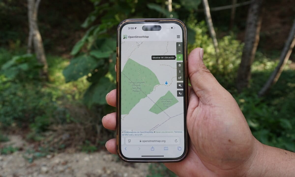
Banner image: OpenStreetMap maps show the communal forest of San José Poaquil. Image by Jessica Guifarro.
FEEDBACK: Use this form to send a message to the author of this post. If you want to post a public comment, you can do that at the bottom of the page.


