- In northeastern Gabon, the community of Massaha used participatory mapping to document ancestral villages, sacred sites and traditional land use inside a rainforest slated for industrial logging.
- Their biocultural map revealed a long history of occupation that colonial records and modern conservation maps had largely overlooked.
- The evidence helped the community argue for protection of their forest, prompting government intervention that halted logging and opened discussions about formal conservation.
- The case highlights how local knowledge and community-led mapping can complement global conservation data and reshape how forests are understood and protected.
See All Key Ideas
To the cartographers of the modern conservation world, the forests of northeastern Gabon can appear almost empty. Satellite images show a deep green canopy stretching across the Congo Basin. Global datasets classify large tracts as “intact forest landscapes”, areas supposedly free of industrial disturbance and largely untouched by people. On paper, such forests look pristine.
The reality, as residents of the village of Massaha know well, is more complicated.
In recent years the community has been fighting to protect a stretch of rainforest south of their village from industrial logging. The forest, known locally as Ibola Dja Bana Ba Massaha—“the reserve of all Massaha’s children”—lies within a concession once allocated to a logging company. For generations the people of Massaha have hunted, fished and farmed there. Sacred lakes and ritual sites lie beneath the canopy. The remains of ancestral villages dot the forest floor.
Yet none of this appeared on the maps that guided official decisions.
The gap between these two views of the forest is the subject of a recent study examining Massaha’s campaign to document its territory. The researchers compared global conservation maps and colonial-era cartography with a detailed map created by the community itself. The result reveals something striking: the forest that appears empty in official datasets is, in fact, layered with history and meaning.
Image courtesy of Ivindo FM.
Massaha’s map emerged from an unusually collaborative process. Using participatory geographic tools, villagers gathered to project satellite images of their territory onto a wall. Elders identified former settlements, sacred clearings and fishing sites remembered from oral histories. Community members then walked the forest with GPS units to confirm the locations. The result was a living map of an ancestral territory covering roughly 11,800 hectares.
What they found contrasts sharply with official records. Colonial maps produced between 1897 and the 1960s recorded only a handful of villages near the area. Massaha’s mapping documented fifteen ancestral villages in the same landscape. Sacred sites, lakes and forest clearings important for wildlife were absent from earlier cartography altogether.
Community biocultural mapping of Ibola Dja Bana Ba Massaha: community-collected data on biocultural sites and territorial limits (north of the national road are not shown), presented along with available data on logging concessions, roads, rivers, and current villages. Also presented, for the purpose of this study, are 2020 Intact Forest Landscapes (IFLs)
This discrepancy is not simply a cartographic oversight. Colonial administrators had little reason to document small settlements scattered through forest interiors. Their maps served commerce and control: tracking roads, railways and extractive resources rather than the cultural geography of local communities. Later global conservation maps inherited some of those blind spots.
The problem extends into the age of satellites. International conservation planning increasingly relies on large datasets such as the Intact Forest Landscapes map or the Global Forest Watch deforestation alerts. These tools are powerful but limited. They detect industrial activity visible from above, yet struggle to capture what happens beneath the canopy: hunting territories, sacred groves or small-scale disturbance.
In Massaha’s case the mismatch became obvious during patrols organized by villagers themselves. Community members documented logging activities in areas where satellite alerts reported none. Relying on global datasets alone would have suggested a far larger expanse of untouched forest than actually existed.
Logging mapped by Massaha (a July 2023 community patrol), some of which was not detected by Global Forest Watch’s Integrated Deforestation Alerts (from August 16th, 2020, the first available data after Massaha submitted its request, to February 15th, 2025, the most recently available data as of analysis conducted on March 4th, 2025)
For Massaha, mapping was not an academic exercise. It became a tool of advocacy. The community used the maps to demonstrate long-term occupation of the territory and to argue that their forest should be removed from the logging concession and recognized as a community-conserved area.
Their campaign gained momentum. After independent reporting drew attention to the conflict, international organizations pressed the government to examine the case more closely. When Gabon’s environment minister eventually visited the area, he saw firsthand what the maps revealed: traces of former villages, sacred sites and the cultural landscape that logging threatened to erase. Soon afterward the government halted logging and ordered the company to withdraw from the contested forest.
The episode prompted a broader debate within Gabon about recognizing community “territories of life”—lands conserved and managed by local people. The concept is gaining attention in global conservation policy, especially as governments commit to protecting 30% of land and seas by 2030.
Massaha’s experience suggests that such commitments may depend as much on local knowledge as on satellites.
Maps are powerful instruments. They shape how landscapes are understood and governed. When global datasets portray forests as empty wilderness, they risk erasing the people who have lived there for centuries. Community mapping offers a corrective, grounding abstract conservation targets in lived landscapes.
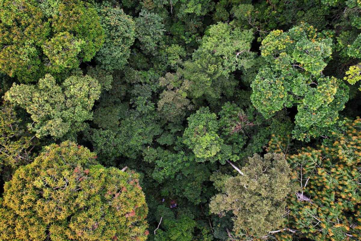
Left: Paraecologist and author Serge Ekazama Koto maps a previously undocumented bai, a swampy forest clearing important to biodiversity. Right: aerial view of Ibola Dja Bana Ba Massaha showing the issuaka (mature forest) south of the Liboumba (Abombwe) river. Near the river are many ancestral villages and sacred sites unmarked by colonial and global maps; the forest in the background was classified as within an Intact Forest Landscape (IFL) in 2020 but has since been logged. Photos by Guy Rodger Imbembi and Walter Mbamy
The forest around Massaha still holds traces of its past. Elders recall a ritual fishing tradition known as etoubili, once carried out with large dugout canoes carved from bilinga trees. The canoes lay buried in river mud for decades before villagers recently unearthed them during ceremonies linked to their campaign to protect the forest.
To outside observers, the forest might appear untouched. To Massaha’s residents, it is full of memory.
Their maps show that conservation sometimes begins not with satellites, but with stories—and with the people who remember where those stories took place.
Citation:
Ibola Dja Bana Ba Massaha, Serge Ekazama Koto, Gretchen M. Walters, Honorine Asatsi Mabo, Fulbert Makala, Paulin Ndanga Azeon, Jean Mabo, Philippe N. Mandoumilele, Jean P. Hendje, Dieu-Donne Baza Djia, HB Betotobeya, Modeste Ndongoabendje, Ernest Maı dji, Story Maloumambomba, Djiese Koumokoukou, Germain Kotomoukaye, Fulgence Mbengoy, Boris Bobouagno, Garance Bopounda, Dieu-Donne Ngouba, Yanick Akouboua, Mathurien Haya, Steeven Mabe Bleck, Gervais Djabouemi, Aime J. Bobeloubouangoy, Vincent Malingui, Davy Ikakaboua, Didier T. Louma, Paul Mbouya, Guy R. Imbembi, Felix Eboulou, Patrick Ipengongoy, George Moulingui, Hines Mabika, Julia Walker, Me dard Mamouaka Bayadi, Simon Cheseaux, Alex Ebang Mbele´, Graden Z. L. Froese (2026). Community biocultural mapping reveals historical occupation and enables defense of African rainforests. Ambio https://doi.org/10.1007/s13280-025-02334-2