
- Between Oct. 1 and 21, a U.S government-funded vessel, the E/V Nautilus, conducted an expedition in the Cook Islands’ exclusive economic zone (EEZ), following an agreement between the U.S. and the Cook Islands to “advance scientific research and the responsible development of seabed mineral resources.”
- During the 21-day expedition, the E/V Nautilus mapped more than 14,000 square kilometers (5,400 square miles) of the Cook Islands’ seafloor while also documenting deep-sea biodiversity.
- Environmental activists protested the expedition, arguing it would help accelerate deep-sea mining in the Cook Islands. The crew of the E/V Nautilus, however, rejects the accusation.
- The Cook Islands government has issued three deep-sea mining exploration licenses, which will expire in 2027. One company operating in the Cook Islands has said it hopes to apply for an exploitation license in 2027.
See All Key Ideas
Thousands of meters below the ocean’s surface, a camera attached to a remotely operated vehicle captured a ghostly white creature gliding above a plain of polymetallic nodules — mineral-rich rocks that resemble blackened potatoes. The animal’s orchid-shaped fins undulated as it cruised through the water, while its spindly tentacles trailed behind. This otherworldly creature was a bigfin squid (genus Magnapinna), an organism that scientists have spotted fewer than two dozen times, and one that has never been physically captured.
Adam Soule, a geologist and oceanographer who directs the U.S.-based Ocean Exploration Cooperative Institute, the organization leading the expedition on a vessel known as the E/V Nautilus, said the bigfin squid sighting generated a rush of excitement. (The Ocean Exploration Cooperative Institute and its U.S.-based partner organization, the Ocean Exploration Trust, are operating via a 10-year grant worth $200 million from the U.S. National Oceanic and Atmospheric Administration, or NOAA).
“One of the cool things about the Nautilus is that there’s a lot of people following online, watching in real time and sending in comments,” Soule told Mongabay. “And they were amazed. They were really excited, as was everyone on the ship.”
The footage of the bigfin squid was filmed at a depth of more than 5,000 meters (16,400 feet) in the exclusive economic zone (EEZ) of the Cook Islands, a small Pacific island nation located between American Samoa and French Polynesia. The entire Cook Islands EEZ, which spans 1.9 million square kilometers (about 734,000 square miles), also operates as a multiple-use marine protected area known as the Marae Moana. During a three-week exploration expedition between Oct. 1 and 21, the vessel’s remotely operated vehicle recorded many other mysterious-looking deep-sea creatures, including lizardfish (genus Synodontidae), isopods, sea cucumbers, octopuses and variously shaped sponges, using a new camera shooting in 4K resolution.
For the Cook Islands, the expedition was one of the first major efforts to investigate deep-sea life within its territorial waters, which will help fill gaps in scientific knowledge as the nation contemplates launching a domestic deep-sea mining industry. If this industry goes ahead, it would exploit the polymetallic nodules found in the seafloor environment these sea creatures depend upon — and, according to some critics, irreparably damage the marine environment.
Hans Smit, the CEO of Moana Minerals, a U.S.-owned company that aims to mine in the Cook Islands, has said his company aims to minimize environmental harm. But he also told Mongabay that the company hasn’t fully learned about the environmental impacts yet since it’s “still developing that full picture of what the seafloor looks like.” Other deep-sea mining companies seeking to extract minerals in international waters claim that their commercial operations will not cause considerable harm to the environment.
The scientists on the E/V Nautilus weren’t only documenting biodiversity — they were also charting the seafloor itself.
“The Cook Islands EEZ is not well mapped,” Soule said. “So every contribution there is really important for them to understand their environment.”
The mission focused on “previously unmapped areas of deep abyssal plain habitats and the Manihiki Plateau,” said Jamie Zaccaria, media and outreach coordinator at the Ocean Exploration Trust. In total, she said, the mission mapped more than 14,000 km2 (about 5,400 mi2) of seafloor. That’s about 0.7% of the Cook Islands’ EEZ, and adds to the 30% that had already been mapped.
Map showing the previous multibeam mapping of the Cook Islands EEZ (purple) and the multibeam mapping conducted by the E/V Nautilus in October 2024 (yellow). Image courtesty of the Ocean Exploration Trust.
(On Oct. 15, the Cook Islands government announced that it had received approval to extend its seafloor jurisdiction over an additional 350,000 km2, or about 135,000 mi2, of its continental shelf, beyond the boundaries of its EEZ. With this extension, the E/V Nautilus expedition would have mapped only 0.6% of the Cook Islands’ EEZ, bringing total mapped coverage to just about 25%.)
Soule said the team used multibeam echo sounders, a kind of sonar, to generate maps of the seafloor at a resolution, or pixel size, of 60 meters (about 200 feet). These, he said, were “more than two orders of magnitude improvement from existing maps.”
“These maps don’t provide any direct evidence of minerals, but can be used by scientists to create models of where minerals might be present,” Soule said. “We were not estimating the amount of minerals present with this work, but instead collecting data and observations that may be used by Cook Islands managers to inform decision-making and by the public for their free use.”
Among the officials joining the expedition was John Parianos of the Cook Islands Seabed Minerals Authority. In an interview with Aotearoa New Zealand public broadcaster RNZ, Parianos said the data the E/V Nautilus collected will feed into the environmental baseline information that the Cook Islands government will use to eventually decide whether to launch the mining industry. He said they currently “don’t know enough to make a decision.”
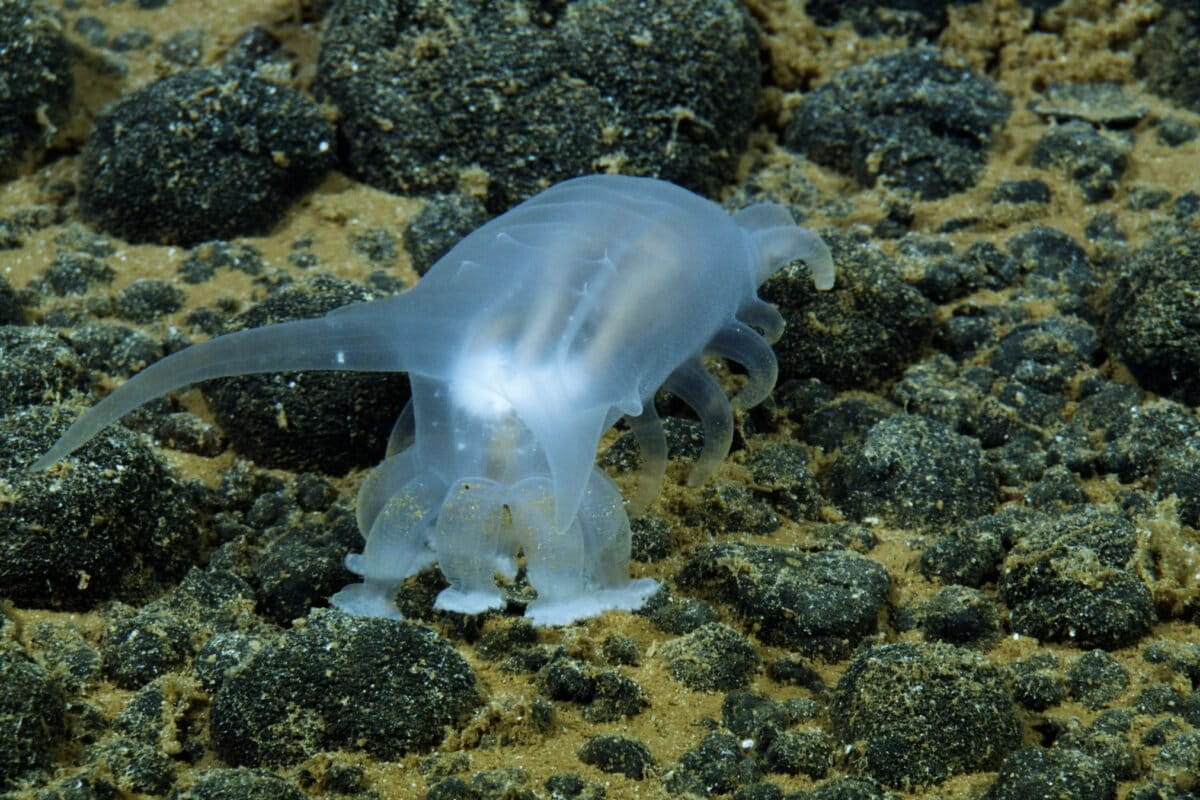
The E/V Nautilus’ remotely operated vehicle (ROV) documented deep-sea biodiversity and mapped the seafloor in the Cook Islands’ EEZ. Image by Ocean Exploration Trust.
The E/V Nautilus has conducted numerous other exploratory oceanographic missions across the Pacific, mapping the seafloor and documenting biodiversity in places such as Palau, American Samoa and the Mariana Islands.
But this particular mission was slightly different due to the political circumstances that enabled it to happen. The vessel began traveling to the Cook Islands on very short notice, not long after the U.S. announced on Aug. 5 that it had struck an agreement with the Cook Islands to “advance scientific research and the responsible development of seabed mineral resources.” This agreement followed a U.S. executive order in April that called for the acceleration of the deep-sea mining industry for U.S. national security reasons.
“We usually spend a year, or year and a half, planning an expedition, and this one came together very quickly in a period of a couple months,” Soule said.
When the E/V Nautilus returned to port in Rarotonga on Oct. 21, four environmental activists kayaked out to greet it, protesting deep-sea mining and the expedition’s “political motive.”
Activists confront the E/V Nautilus at Rarotonga port in October 2025. Image by Robin Hammond / Greenpeace.
June Hosking of the Te Ipukarea Society speaking at a deep-sea mining protest in September 2024. Image by Elizabeth Claire Alberts for Mongabay.
Kelvin Passfield, technical director for the Te Ipukarea Society (TIS), a Cook Islands environmental NGO, told Mongabay in a message he agreed that the mission happened quickly to advance the deep-sea mining industry in the Cook Islands. But he also said the biodiversity that the E/V Nautilus documented was an “eye-opener” and could provide “valuable information” to challenge the push for deep-sea mining, which TIS opposes.
June Hosking, the TIS president, told Mongabay in a message that she and other members of TIS had participated in meetings with U.S. officials and scientists from OET in August in the lead-up to the mission. Hosking added she requested the scientific team of the E/V Nautilus to “first consider the function of the nodules to deep sea ecosystems” and focus on biodiversity.
Soule called the protest against the E/V Nautilus “odd,” since the vessel was conducting research to learn about the deep sea, which he said many deep-sea mining critics argue needs to happen before mining can go forward. Speaking on a personal basis, he also said he rejects the notion that the expedition would contribute to mineral extraction.
Cook Islands Prime Minister Mark Browne praised the “significant collaboration” between the Cook Islands and the U.S., saying the expedition marked an important milestone.
Polymetallic nodules collected from the seafloor within the Cook Islands exclusive economic zone (EEZ). Image by Elizabeth Claire Alberts for Mongabay.
Hans Smit of Moana Minerals aboard the Anuanua Moana, a research vessel utilized by his company. Image by Elizabeth Claire Alberts for Mongabay.
The Cook Islands government has issued three deep-sea mining exploration licenses set to expire in 2027, two of which are held by U.S. companies. It hasn’t granted any commercial mining licenses. However, Smit from Moana Minerals, one of the companies with an exploration license, told Mongabay he’s hopeful his company will apply for a commercial mining license in 2027, and be commercially mining in 2028 or 2029.
Soule told Mongabay that OET isn’t collaborating with any of the commercial deep-sea mining companies in the Cook Islands, but that the information gathered on the E/V Nautilus expedition would eventually be placed in public archives for anyone to access. He added he hopes the E/V Nautilus can conduct further expeditions in the Cook Islands.
“It’s a tough decision that they have ahead of them,” Soule said of the country’s need to determine whether to start deep-sea mining, “but hopefully we can contribute data that will help them deal with that challenge.”
Elizabeth Claire Alberts is a senior staff writer for Mongabay and was recently a fellow with the Pulitzer Center’s Ocean Reporting Network. Find her on Bluesky and LinkedIn.
Banner image: Deep-sea cucumber. Image by Ocean Exploration Trust.
Pacific alliance adopts moratorium on deep-sea mining, halting resurgent PNG project


