PAGASA says Pilandok is expected to be a short-lived tropical cyclone
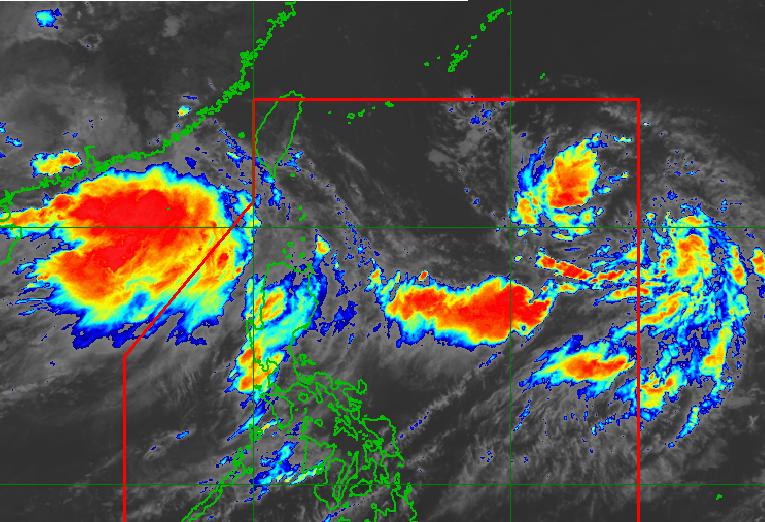
MANILA, Philippines – The low pressure area inside the Philippine Area of Responsibility has developed into a tropical depression at 8 am Sunday, August 30.
Tropical Depression Pilandok was located at 1,225 kilometers east of extreme Northern Luzon, according to the Philippine Atmospheric, Geophysical, and Astronomical Services Administration (PAGASA). It is moving west northwestward at 15 kilometers per hour, with maximum sustained winds of 45 km/h and gustiness of up to 55 km/h.
Pilandok is expected to continue moving in the same direction until Monday, August 31, before turning northwestward to north northwestward. PAGASA said the tropical depression is “less likely” to make landfall and will remain far from the Philippine landmass.
“Pilandok is expected to be a short-lived tropical cyclone and is forecast to remain a tropical depression throughout the forecast period before weakening into a remnant low over the Philippine Sea south of the southern islands of Japan on Tuesday (September 1),” PAGASA said in its 11 am bulletin Saturday.
Meanwhile, Tropical Depression Saudel (formerly referred to as Obet), which is being monitored outside PAR, has weakened into a low pressure area. It still has a “medium” chance of redeveloping into a tropical depression.
Below is PAGASA’s latest heavy rainfall outlook due to the enhanced southwest monsoon or habagat:
Sunday noon, August 30, Monday noon, August 31:
- Heavy to intense rain (100-200 millimeters): Ilocos Sur, Pangasinan, La Union, Benguet, Bataan, Zambales, Tarlac, and Pampanga
- Moderate to heavy rain (50-100 mm): Metro Manila, Ilocos Norte, Abra, Apayao, Kalinga, Ifugao, Mountain Province, Nueva Vizcaya, Nueva Ecija, Bulacan, Rizal, Cavite, Laguna, Batangas, and Occidental Mindoro
Monday noon, August 31, to Tuesday, September 1:
- Heavy to intense rain (100-200 mm): Ilocos Norte, Ilocos Sur, La Union, Pangasinan, Abra, Benguet, Zambales, and Bataan
- Moderate to heavy rain (50-100 mm): Apayao, Kalinga, Ifugao, Mountain Province, Batanes, Tarlac, Pampanga, Bulacan, Metro Manila, and Cavite
Tuesday, September 1, to Wednesday, September 2:
- Heavy to intense rain (100-200 mm): Ilocos Norte, Ilocos Sur, Abra, and Benguet
- Moderate to heavy rain (50-100 mm): Batanes, Apayao, Kalinga, Ifugao, Mountain Province, La Union, Pangasinan, Tarlac, Pampanga, Zambales, and Bataan
These areas should watch out for flash floods and landslides.
The enhanced southwest monsoon is also bringing strong to gale-force gusts over the following areas, especially in coastal and upland areas exposed to winds:
Sunday, August 30:
- most of Luzon and Visayas, Zamboanga del Norte, Misamis Occidental, Lanao del Norte, Misamis Oriental, Camiguin, Dinagat Islands, Davao Occidental, and Davao Oriental
Monday, August 31:
Tuesday, September 1:
- most of Luzon and Visayas, Zamboanga del Norte, Misamis Occidental, Lanao del Norte, Misamis Oriental, Camiguin, Dinagat Islands, Davao Occidental, and Davao Oriental
Moderate to rough seas will also persist in the following areas:
Up to rough seas (small vessels should not venture out to sea)
- Seaboards of Batanes, Ilocos Norte, Ilocos Sur, and Zambales; the northern and western seaboards of Babuyan Islands; the western seaboard of Pangasinan — waves up to 3.5 meters high
- Seaboard of Lubang Islands; the western seaboard of northern La Union, Bataan, northern Occidental Mindoro, and Kalayaan Islands — waves up to 3 meters high
Up to moderate seas (small vessels should take precautionary measures or avoid sailing, if possible)
- Western seaboards of Cavite, Batangas, Occidental Mindoro, northern Palawan including Calamian Islands; the eastern seaboard of Davao Oriental; the remaining seaboards of La Union and Kalayaan Islands — waves up to 2.5 meters high
- Seaboards of Isabela and Surigao del Sur; the southern seaboards of Cuyo Islands, Antique, Iloilo, and Guimaras; the western seaboard of Negros Occidental; the remaining western seaboard of mainland Palawan — waves up to 2 meters high
– Rappler.com