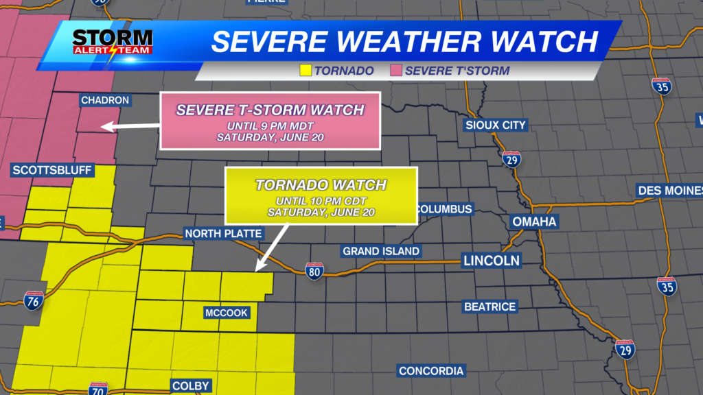
Storms are likely on and off across Nebraska Saturday into Sunday. Heavy rain and severe weather is possible.
For up to the minute radar, go HERE.
For the latest warnings, go HERE.
For a live look at our Nebraska Weather Cams, go HERE.
And we would love to see video of any storm footage you may get (safely!). You can upload that using our Now Local News App HERE.
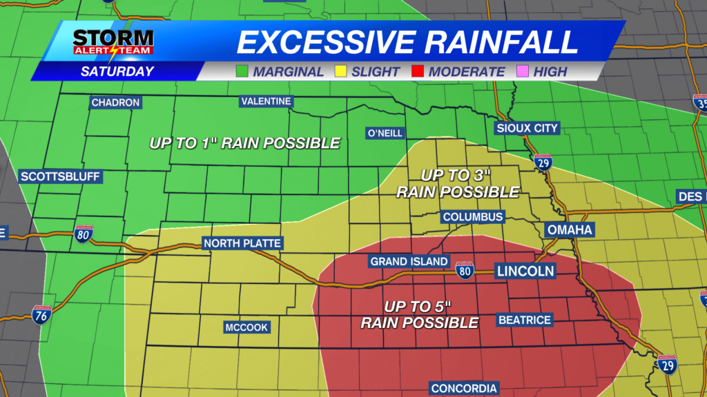
The highest risk for heavy rain is in south central and SE Nebraska. Most in this area will see a couple inches of rain, but some isolated spots may see up to 5″.
Because of this heavy rain potential, a Flood Watch is in place for south central and SE Nebraska through Sunday morning.
Above is what our StormCast weather model is saying for timing, duration, and location of the storms Saturday into Sunday.
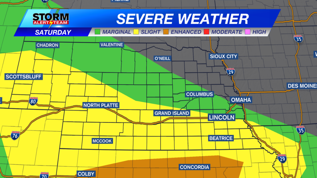
A level 1 Marginal Risk, a level 2 Slight Risk, and a level 3 Enhanced Risk is in place for the potential for severe storms Saturday morning, afternoon, evening, and overnight into early Sunday. Large hail, damaging wind, and isolated tornadoes are possible.
Parts of Nebraska have a risk for large hail Saturday. Not everybody will see the large hail, but the storms that can get strong to severe will have hail in them. The area in the brown shaded area may see hail up to 1” in diameter. The area shaded in yellow may see hail up to golf ball in size. The area shaded in red may see hail as big as tennis balls.
Parts of Nebraska have a chance for tornadoes Saturday. The green shaded “low” risk doesn’t sound high, but it’s not zero. The “low” risk usually means one or two spin up tornadoes are possible in this area. The area with the brown shaded “medium low” area may see slightly stronger tornadoes.
Damaging wind Saturday may be the main risk. Not everybody will see very strong winds, but the storms that can get severe will see very gusty winds. The area in the brown shaded area may see wind up to 60 mph. The area shaded in yellow may see wind between 60 and 70 mph. The red shaded area may see wind gusts in excess of 70 mph.
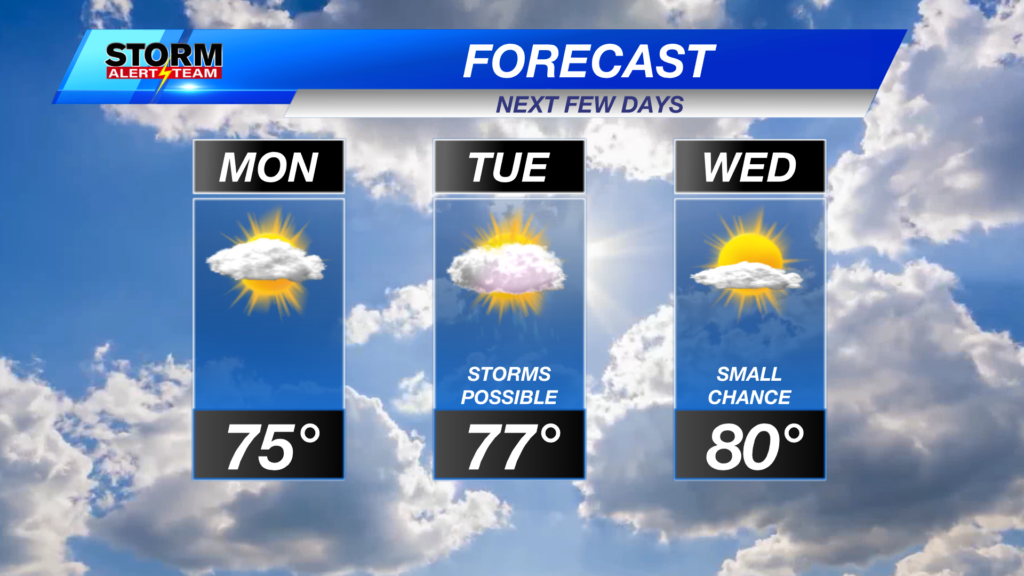
High temperatures on Saturday will be in the 70s and low 80s.
Chief Meteorologist Rusty Dawkins
Facebook: RustyWx
YouTube: RustyWx
TikTok: RustyWx
BlueSky: RustyWx
Instagram: RustyWx
Threads: RustyWx
Twitter: RustyWx
Categories: Channel 8 Eyewitness News Weather, Forecast
Tags: active-alert, Beatrice, Broken Bow, channel-8-eyewitness-news-weather, Columbus, Crete, damaging wind, Fairbury, forecast, Grand Island, hail, Hastings, Kearney, lincoln, lincoln forecast, Lincoln weather, McCook, Nebraska, nebraska weather, Ord, severe, seward, southeast nebraska, storms, tornado, weather, york