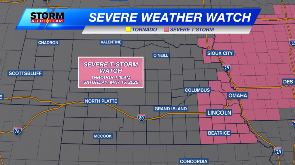
A SEVERE THUNDERSTORM WATCH is in place for parts of eastern Nebraska through 1:00AM tonight. Large hail, damaging wind, and isolated tornadoes will be possible.
For up to the minute radar, go HERE.
For the latest warnings, go HERE.
For a live look at our Nebraska Weather Cams, go HERE.
And we would love to see video of any storm footage you may get (safely!). You can upload that using our Now Local News App HERE.
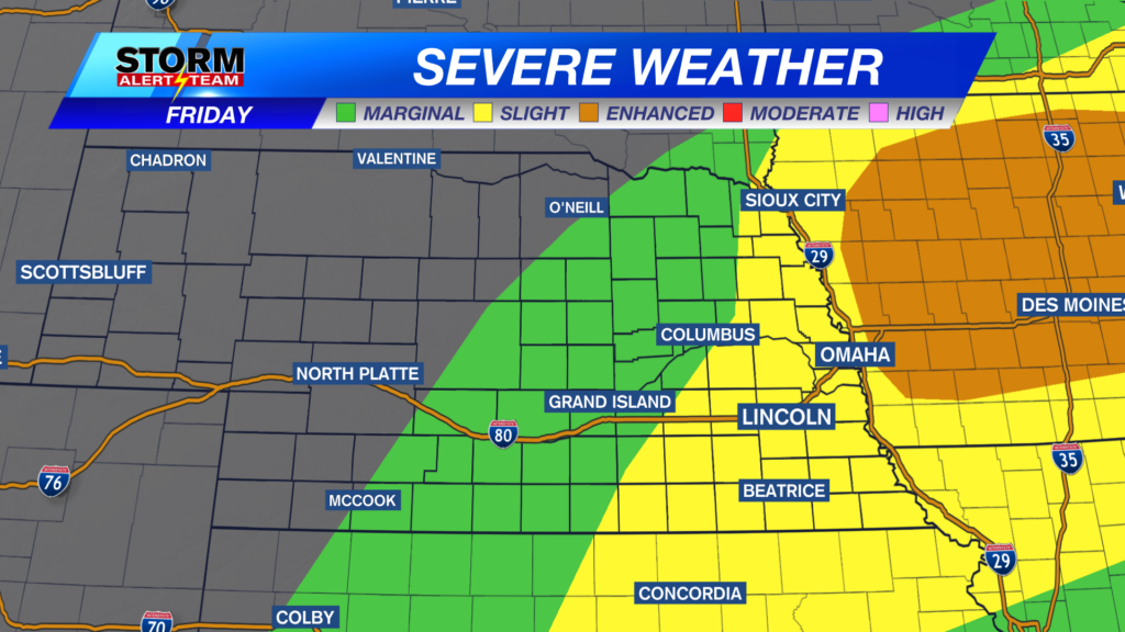
Parts of eastern Nebraska have a risk for large hail this evening. Not everybody will see the large hail, but the storms that can get strong to severe will have hail in them. The area in the brown shaded area may see hail up to 1” in diameter. The area shaded in yellow may see hail up to golf ball in size. The area shaded in red may see hail in excess of 2″.
There is a chance for tornadoes this evening, as well. 2% doesn’t sound high, but it’s not zero. The 2% usually means one or two spin up tornadoes are possible in this area. The area with the brown shaded area may see slightly stronger ones.
There is also a risk of damaging wind this evening. Not everybody will see very strong winds, but the storms that can get severe will see very gusty winds. The area in the brown shaded area may see wind up to 60 mph. The area shaded in yellow may see wind between 60 and 70 mph. The area in red may see wind in excess of 70 mph.
We then have another chance for severe weather on Saturday. The slide show above shows all of the severe weather threats in place. Storms will start to move into western Nebraska by late afternoon with hail, damaging wind, and tornadoes possible. The storms will then push from west to east through the day into the night.
Above is what our StormCast weather model is saying for timing, duration, and location of the storms on Saturday.
Sunday might be the roughest day of all. There is a level THREE “Enhanced Risk” for severe storms across much of the state. A level 2 “Slight Risk” is surrounding the level 3 risk and level 1 “Marginal Risk” is in place for western Nebraska. All severe weather threats are in place for this. Storm timing and location will be determined after the storms Friday and Saturday.
There’s one more day with a severe weather threat for the eastern half of the state on Monday. This will be the last severe weather threat day, but it could be as bad as Sunday.
Chief Meteorologist Rusty Dawkins
Facebook: RustyWx
YouTube: RustyWx
TikTok: RustyWx
BlueSky: RustyWx
Instagram: RustyWx
Threads: RustyWx
Twitter: RustyWx
Categories: Channel 8 Eyewitness News Weather, Forecast
Tags: active-alert, Beatrice, Broken Bow, channel-8-eyewitness-news-weather, Columbus, Crete, damaging wind, Fairbury, forecast, Grand Island, hail, Hastings, Kearney, lincoln, lincoln forecast, Lincoln weather, McCook, Nebraska, nebraska weather, Ord, severe, seward, southeast nebraska, storms, tornado, weather, york