One final round of strong to severe storms is possible on Friday as a cold front swings through the state. Here’s what to know about Friday’s risk.Storms are most likely mid to late afternoonEastern Iowa has the highest chance of severe weatherLarge hail and damaging winds are the highest threatsTornado warning expires for parts of central IowaThe tornado warning for four central Iowa counties has expired for some of central Iowa, including eastern Tama County.Parts of Marion and Mahaska counties are also under a warning through 3:45 p.m.A tornado warning for northern Poweshiek County will be in effect until 4:15 p.m.Hail hits central IowaKCCI viewers have sent in some photos of hail that struck the state Friday afternoon:Tornado warning issued for parts of Marshall, Poweshiek, Tama and Jasper countiesThose four counties will be under a tornado warning until 3:15 p.m., according to the national weather service in Des Moines.Here’s how to make sure your phone provides severe weather alertsWhen storms are in the forecast, you want to make sure your mobile phone settings allow for alerts that warn you of severe weather.The U.S. Homeland Security Department says to check your phone’s settings and ensure you have “Government Alerts” or “Emergency Alert Messages” enabled.You can keep track of the weather wherever you are with the KCCI app: Apple | Google PlayWe’ll send you weather alerts and you can track live radar right on your phone.Tornado safety tipsIf you are in a home, small building, nursing home, hospital, factory, shopping center or high-rise building:Go to a pre-designated area such as a safe room, basement, storm cellar or the lowest building level. If there is no basement, go to the center of a small interior room on the lowest level (closet, interior hallway) away from corners, windows, doors and outside walls. Put as many walls as possible between you and the outside. Get under a sturdy table and use your arms to protect your head and neck.If you are in a pickup line at your child’s school, get inside the building as quickly as possible.In a high-rise building, go to a small interior room or hallway on the lowest floor possible.Make sure you are wearing sturdy shoes.Do not open windows.If you are in a mobile home, manufactured office building or camper:Get out immediately and go to a pre-identified location such as the lowest floor of a sturdy nearby building or a storm shelter. Mobile homes, even if tied down, offer little protection from tornadoes.If you are not in a sturdy building, there is no single research-based recommendation for what last-resort action to take because many factors can affect your decision.Possible actions (which do not guarantee safety) include:Immediately get into a vehicle, buckle your seat belt and try to drive to the closest sturdy shelter. If your vehicle is hit by flying debris while you are driving, pull over and park.Take cover in a stationary vehicle. Put the seat belt on and cover your head with your arms and a blanket, coat or cushion if possible.Lie in an area noticeably lower than the level of the road and cover your head with your arms and a blanket, coat or cushion if possible.Severe thunderstorm warnings expire for parts of central IowaSevere thunderstorm warnings were issued for Polk, Warren, Dallas, Madison counties until 2:45 p.m. The warning for part of Polk County, specifically including Des Moines, was allowed to expire at 2:30.Marshall County is now under a severe thunderstorm warning.Iowa weather: Tracking thunderstorms as they move through central IowaTornado watch through 8 p.m. FridayA tornado watch has been issued for much of central Iowa and all of eastern Iowa through 8 p.m. A line of strong to severe storms will develop this afternoon and race eastward with increasing severe weather risks. The watch will likely be cleared for central Iowa well before 8 p.m.Schools dismiss early Some Iowa schools are dismissing early Friday due to expected severe weather. As of 1 p.m., three districts have adjusted Friday afternoon schedules:Albia is closed, with no evening activitiesPekin is closing at 2:30 p.m., with no evening activitiesSouth Tama is closing at 2:25 p.m.You can see our updated list of early dismissals here.Level 2 of 5 severe risk FridayA little good news in the forecast today is that the severe risk was downgraded slightly for most of central Iowa to a slight risk, or level 2 out of 5 risk for severe weather today. The higher severe risk continues for mainly eastern Iowa into Wisconsin and Illinois.Large hail up to 2.5 inches in size and damaging wind gusts of 60 to 75mph will be the main risks with any storms that develop over central Iowa. While there is a limited tornado risk, that risk grows as storms push to the east, with the highest tornado risk over eastern Iowa into Wisconsin and Illinois.Line of storms expected later in the dayCurrent trends point toward storms developing by early afternoon over portions of central and eastern Iowa. A cold front will be pushing into the middle of the state by 1 to 3pm, kicking off a line of storms.It is possible that the front could be through the Des Moines metro, and mostly east of the I-35 corridor by the time storms develop. However, if there is any small change in the timing of that front, it could result in the storms developing over or just west of the metro, so stay alert to the weather conditions this afternoon.With the front possibly east of I-35 by 3pm, that puts the highest severe weather risk over eastern and southeast Iowa. Storms should race eastward past Cedar Rapids and Iowa City by 5 to 6pm, if not a little earlier. The severe storms will likely be out of central Iowa no later than 7pm, though some showers and isolated rumbles could linger through 10pm mainly east of I-35.As the storms push to the east, they are expected to develop into a full in, which would make tornadoes a little less likely. However, some short-live spin-up tornadoes are still possible even in when storms have formed into a line.With the front moving through so quickly, the western half of Iowa may not see any storms as all with this system. Once the front moves through, expect cooler conditions with temperatures falling into the 40s by evening.
DES MOINES, Iowa —
One final round of strong to severe storms is possible on Friday as a cold front swings through the state.
Here’s what to know about Friday’s risk.
- Storms are most likely mid to late afternoon
- Eastern Iowa has the highest chance of severe weather
- Large hail and damaging winds are the highest threats
Tornado warning expires for parts of central Iowa, extended for Tama County
The tornado warning for four central Iowa counties has expired for some of central Iowa. A new warning is in effect for eastern Tama County.
Parts of Marion and Mahaska counties are also under a warning through 3:45 p.m.
A tornado warning for northern Poweshiek County will be in effect until 4:15 p.m.
Hail hits central Iowa
KCCI viewers have sent in some photos of hail that struck the state Friday afternoon:
Troy Underhill
Troy Underhill shared this photo of hail near Le Grand Friday afternoon.
Nicholas Breckenridge
KCCI viewer Nicholas Breckenridge sent in this photo of hail from Colfax shortly before 3 p.m. Friday.
Tornado warning issued for parts of Marshall, Poweshiek, Tama and Jasper counties
Those four counties will be under a tornado warning until 3:15 p.m., according to the national weather service in Des Moines.
Here’s how to make sure your phone provides severe weather alerts
When storms are in the forecast, you want to make sure your mobile phone settings allow for alerts that warn you of severe weather.
The U.S. Homeland Security Department says to check your phone’s settings and ensure you have “Government Alerts” or “Emergency Alert Messages” enabled.
You can keep track of the weather wherever you are with the KCCI app: |
We’ll send you weather alerts and you can track live radar right on your phone.
This content is imported from YouTube.
You may be able to find the same content in another format, or you may be able to find more information, at their web site.
Tornado safety tips
If you are in a home, small building, nursing home, hospital, factory, shopping center or high-rise building:
- Go to a pre-designated area such as a safe room, basement, storm cellar or the lowest building level. If there is no basement, go to the center of a small interior room on the lowest level (closet, interior hallway) away from corners, windows, doors and outside walls. Put as many walls as possible between you and the outside. Get under a sturdy table and use your arms to protect your head and neck.
- If you are in a pickup line at your child’s school, get inside the building as quickly as possible.
- In a high-rise building, go to a small interior room or hallway on the lowest floor possible.
- Make sure you are wearing sturdy shoes.
- Do not open windows.
If you are in a mobile home, manufactured office building or camper:
- Get out immediately and go to a pre-identified location such as the lowest floor of a sturdy nearby building or a storm shelter. Mobile homes, even if tied down, offer little protection from tornadoes.
If you are not in a sturdy building, there is no single research-based recommendation for what last-resort action to take because many factors can affect your decision.
Possible actions (which do not guarantee safety) include:
- Immediately get into a vehicle, buckle your seat belt and try to drive to the closest sturdy shelter. If your vehicle is hit by flying debris while you are driving, pull over and park.
- Take cover in a stationary vehicle. Put the seat belt on and cover your head with your arms and a blanket, coat or cushion if possible.
- Lie in an area noticeably lower than the level of the road and cover your head with your arms and a blanket, coat or cushion if possible.
Severe thunderstorm warnings expire for parts of central Iowa
Severe thunderstorm warnings were issued for Polk, Warren, Dallas, Madison counties until 2:45 p.m. The warning for part of Polk County, specifically including Des Moines, was allowed to expire at 2:30.
Marshall County is now under a severe thunderstorm warning.
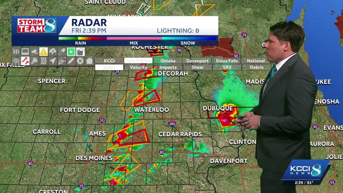
Iowa weather: Tracking thunderstorms as they move through central Iowa
Tornado watch through 8 p.m. Friday
A tornado watch has been issued for much of central Iowa and all of eastern Iowa through 8 p.m. A line of strong to severe storms will develop this afternoon and race eastward with increasing severe weather risks. The watch will likely be cleared for central Iowa well before 8 p.m.
Hearst Owned
Tornado watch through 8pm for all of central and eastern Iowa.
Schools dismiss early
Some Iowa schools are dismissing early Friday due to expected severe weather.
As of 1 p.m., three districts have adjusted Friday afternoon schedules:
- Albia is closed, with no evening activities
- Pekin is closing at 2:30 p.m., with no evening activities
- South Tama is closing at 2:25 p.m.
You can see our updated list of early dismissals here.
Level 2 of 5 severe risk Friday
A little good news in the forecast today is that the severe risk was downgraded slightly for most of central Iowa to a slight risk, or level 2 out of 5 risk for severe weather today. The higher severe risk continues for mainly eastern Iowa into Wisconsin and Illinois.
Hearst Owned
Friday afternoon severe weather risk, storms ahead of a cold front with the highest risk in eastern Iowa.
Large hail up to 2.5 inches in size and damaging wind gusts of 60 to 75mph will be the main risks with any storms that develop over central Iowa. While there is a limited tornado risk, that risk grows as storms push to the east, with the highest tornado risk over eastern Iowa into Wisconsin and Illinois.
Line of storms expected later in the day
Current trends point toward storms developing by early afternoon over portions of central and eastern Iowa. A cold front will be pushing into the middle of the state by 1 to 3pm, kicking off a line of storms.
Hearst Owned
Today is a weather impact day for a quick moving line of strong to severe thunderstorms this afternoon.
It is possible that the front could be through the Des Moines metro, and mostly east of the I-35 corridor by the time storms develop. However, if there is any small change in the timing of that front, it could result in the storms developing over or just west of the metro, so stay alert to the weather conditions this afternoon.
Hearst Owned
Storms developing along a cold front by 4pm Friday.
With the front possibly east of I-35 by 3pm, that puts the highest severe weather risk over eastern and southeast Iowa. Storms should race eastward past Cedar Rapids and Iowa City by 5 to 6pm, if not a little earlier. The severe storms will likely be out of central Iowa no later than 7pm, though some showers and isolated rumbles could linger through 10pm mainly east of I-35.
Hearst Owned
Storms pushing east by 7pm Friday.
As the storms push to the east, they are expected to develop into a full in, which would make tornadoes a little less likely. However, some short-live spin-up tornadoes are still possible even in when storms have formed into a line.
With the front moving through so quickly, the western half of Iowa may not see any storms as all with this system. Once the front moves through, expect cooler conditions with temperatures falling into the 40s by evening.
Hearst Owned
Storm chances increase mid-afternoon, with falling temperatures and gusty winds for the evening.