(INDIANAPOLIS) — Dry and warm into the weekend before a significant pattern change moves in.
Showers early, then clearing today.
A few early morning showers are moving through parts of the state this morning. These will linger through much of the morning hours before gradually moving out as drier air moves in this afternoon. This will allow clouds to break and conditions to improve later today.
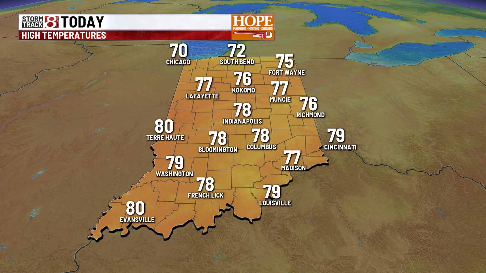
High temperatures will top out near 80°.
Warm and dry Friday
Friday will be the warmest and driest day of the week. High temperatures will be pushing records. We are forecasting a high of 86°. The record high for Friday is 87°, set back in 1896.
Changes arrive late Friday into Saturday.
A strong cold front will move through the Midwest late Friday night into Saturday. This will bring widespread showers and thunderstorms, starting late Friday night and continuing into Saturday. A few storms could be on the stronger, severe side, but due to the timing (overnight and early morning hours), the overall severe weather threat will be limited.
That said, there is a marginal (Level 1 out of 5) risk for severe weather across western Indiana late Friday night and across eastern Indiana on Saturday. In both cases, damaging winds will be the primary concern. A brief, quick spin-up tornado cannot be ruled out.
As of now, Saturday morning looks pretty soggy, with gradually improving conditions heading into the late afternoon and evening hours.
Much cooler air moves in
Behind Saturday’s cold front, there will be a dramatic temperature drop to close out the weekend. Temperatures will fall 15 to 20 degrees below normal by Sunday and Monday, making it feel much more like early spring again.
Frost potential early next week
The big concern for early next week will be the colder temperatures, especially Sunday night and Monday morning. With high pressure settling over the region, skies will be clear, winds will be light, and temperatures are expected to fall into the low to mid 30s. Areas around and north of I-70 will likely see at least patchy frost — and possibly widespread frost in well-protected areas.
Gradual warm-up returns mid-week
As is typical in mid-April, the cool-down won’t last long. By Tuesday and Wednesday, temperatures will return to the 70s, pushing us back above average. The pattern remains relatively quiet early in the week, with just a slight chance of showers possible by Wednesday.