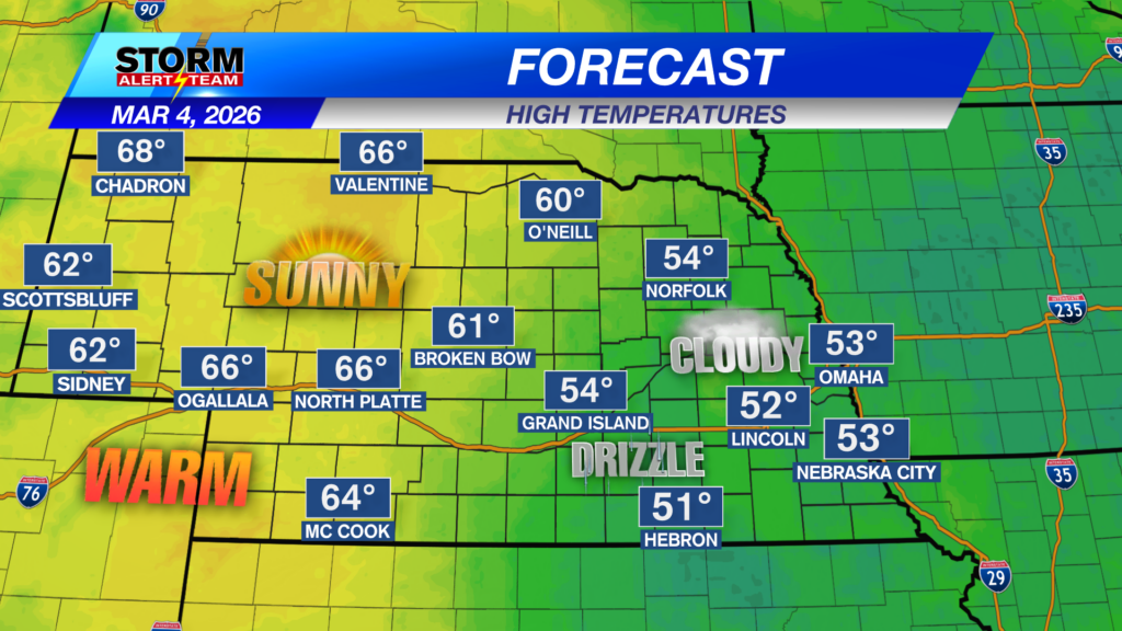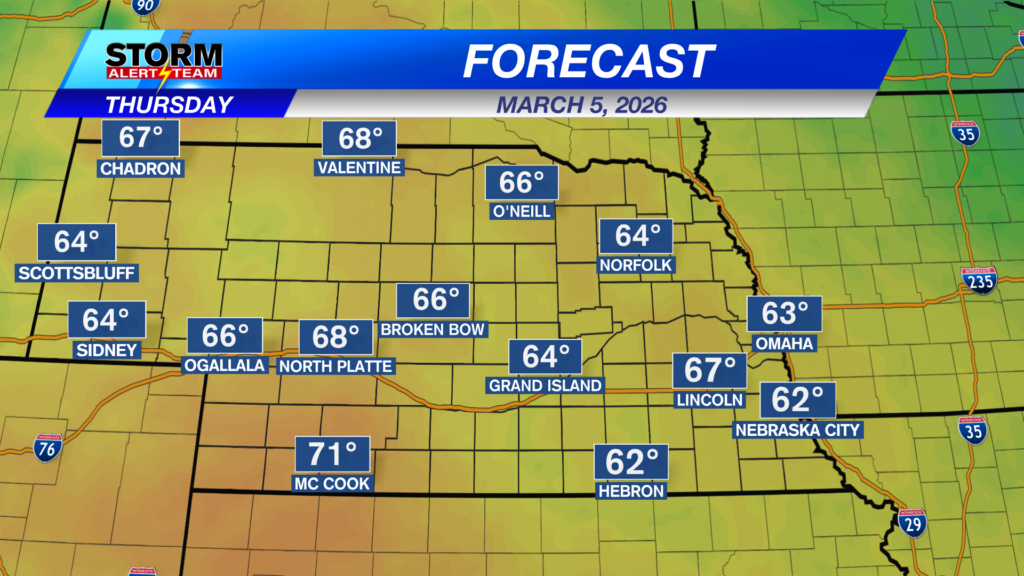
We really warm up on Thursday with temperatures mostly in the 60s. That’s about 20 degrees above average.
Late Thursday into very early Friday, storms will become more likely and a couple of the storms may be strong to severe.
Because of this storm chance, the Storm Prediction Center has us in a level 1 “Marginal Risk”.
Hail the size of quarters will be possible with storms that do form.
Damaging wind may also be an issue, but mostly in far SE Nebraska.
The Friday afternoon, a frontal boundary will be out ahead of a cold front and that may spark some severe storms, as well. Large hail, damaging wind, and a quick spin up tornado will be possible.
A higher level 2 “Slight Risk” and level 3 “Enhanced Risk” is in place for parts of southeast Nebraska. A level 1 “Marginal Risk” is on the western edge of this. Storms will be moving west to east quickly.
Rainfall potential won’t be very high, but if you can get under one of those thunderstorms, you’ll see quite a bit more.
Friday will be another warm day, except for those in the western half of the state!
For up to the minute radar, go HERE.
For the latest warnings, go HERE.
For a live look at our Nebraska Weather Cams, go HERE.
And we would love to see video of any storm footage you may get (safely!). You can upload that using our Now Local News App HERE.
Chief Meteorologist Rusty Dawkins
Facebook: RustyWx
YouTube: RustyWx
TikTok: RustyWx
BlueSky: RustyWx
Instagram: RustyWx
Threads: RustyWx
Twitter: RustyWx
Categories: Channel 8 Eyewitness News Weather, Forecast
Tags: active-alert, Beatrice, Broken Bow, channel-8-eyewitness-news-weather, Columbus, Crete, damaging wind, Fairbury, forecast, Grand Island, hail, Hastings, Kearney, lincoln, lincoln forecast, Lincoln weather, McCook, Nebraska, nebraska weather, Ord, severe, seward, southeast nebraska, storms, tornado, weather, york