The Bottom Line
A coastal storm system is already affecting New Jersey on this Sunday. It will produce a mix of wintry and wet weather, depending upon where in the state you are. This storm has been a beast to forecast, and there are still some big challenges to pinpointing exactly how the day is going to play out. But the general message has become very clear: All of New Jersey will feel inclement weather, and slippery travel is almost a certainty for all.
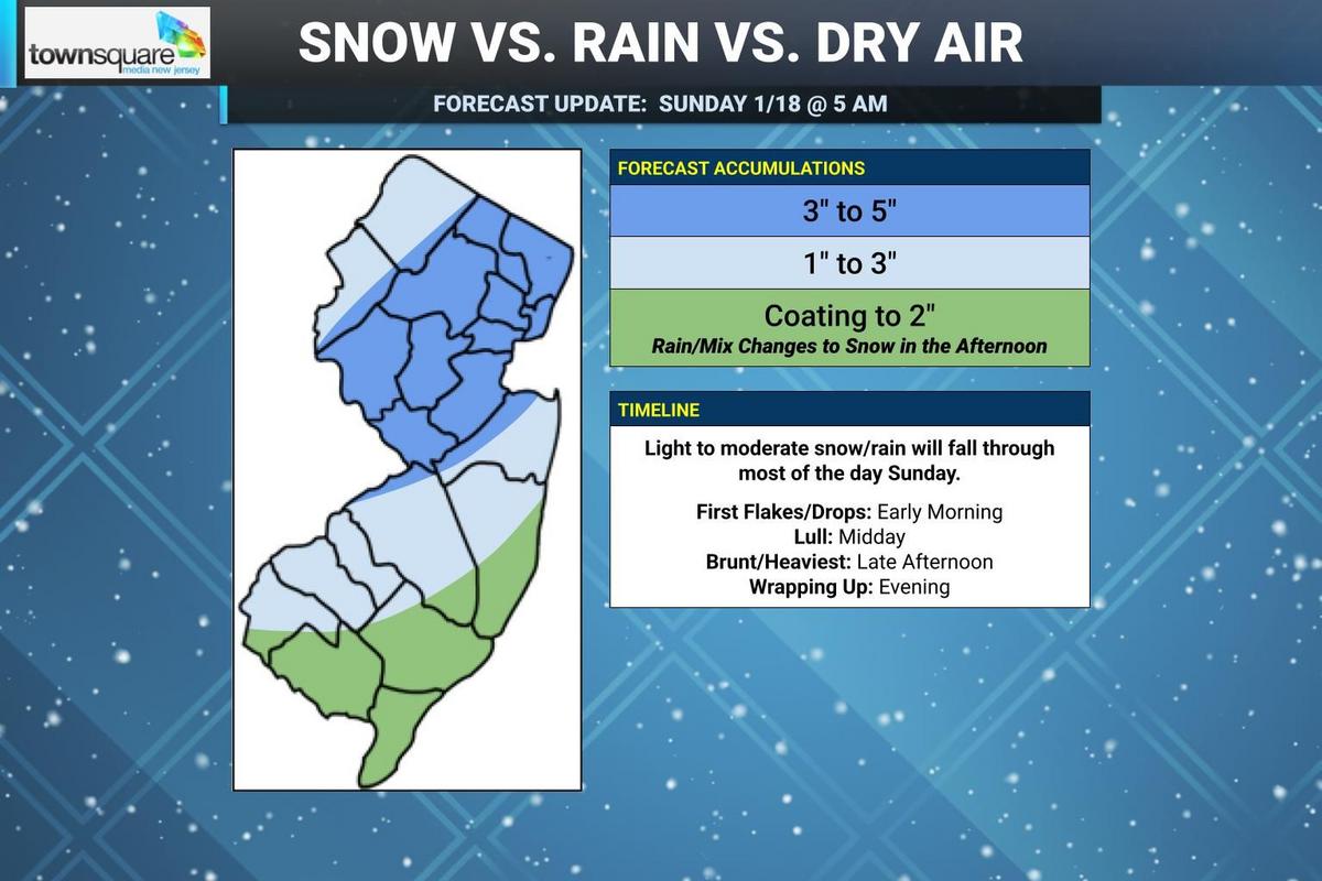
Timeline
As I mentioned, first snowflakes and raindrops already arrived in the early morning hours. We will continue to see periods of precipitation develop throughout the day.
For most of New Jersey, this will take the form of straight snow, with temperatures hovering around 30 degrees for the duration. However, for southern and coastal New Jersey, temperatures are in the mid 30s. That means rain and wintry mix (snow/sleet/rain) are likely for the first half of Sunday, limiting initial accumulations and road issues.
Note: This will not be an all-day steady snow. There will be breaks. In fact, the most model guidance shows a lull moving in around midday as dry air penetrates our atmosphere. So visibility and even road conditions should improve a bit through the lunchtime hours — again, depending where you are.
Then, the steadiest, heaviest precipitation of the storm will come in the afternoon, starting around 3 or 4 p.m. Furthermore, dynamic cooling will force a transition for rainy southeastern New Jersey to all snow. This is when the fastest accumulations will occur, just before and just after sunset.
Once evening falls, snow should begin to dial back. Final flakes should fall in the Garden State around 9 or 10 p.m.
Accumulations: The Sweet Spot
I still think somewhere in the heart of the state, between central and northeastern New Jersey, will see “a few inches” of healthy snowfall. This area will see all snow, and likely some moderate to heavy snow bands during the brunt of the storm.
Final forecast call for Sunday’s winter storm, as of early Sunday morning. (Dan Zarrow, Townsquare Media)Final forecast call for Sunday’s winter storm, as of early Sunday morning. (Dan Zarrow, Townsquare Media)
I have maintained a forecast of 3 to 5 inches max for New Jersey. My final snow forecast has shrunk this area, in an effort to provide a more specific prediction — of course, it gives me great anxiety to pinpoint that so finely because there is always a “margin of error” to these calls. But I’ve drawn with a map that I believe represents the most likely situation on Sunday, with the heaviest accumulations on either side of the Route 1 corridor between Trenton and NYC.
Keep in mind, that 3 to 5 inches is fresh accumulation — on top of whatever fell and stuck to the ground from Saturday’s storm.
Accumulations: NW NJ, Northern Coast, SW NJ
Missing out on the heaviest snow, but still wintry overall. 1 to 3 inches of snow accumulation is still more than enough to make for slick roads. Keep in mind, the closer you are to that 3 to 5 forecast zone, the higher your totals are likely to be.
Accumulations: South and Coast
This coastal storm system track has nudged so close to us that above-freezing temperatures become the story for southern and much of coastal New Jersey. That means Sunday morning will be wet, with mainly rain falling at onset. Once the afternoon comes along, a flip to snow should occur.
Remember, the heaviest precipitation bands are expected late-day — after the changeover. So there is still a chance for light accumulations here. Given the uncertainty of timing and snowfall intensity, I have cast a wide berth of a coating to 2 inches for the South Jersey rain zone. Stay vigilant and flexible, as we play it by ear in terms of what falls and what sticks later on Sunday.
Advisories
The National Weather Service expanded their official Winter Weather Advisory to now include all or part of 17 New Jersey counties. Here is the breakdown:
—Until 8 p.m. for Sussex and Warren counties
—6 a.m. to 8 p.m. for Northwestern Burlington, Camden, Gloucester, Hunterdon, Mercer, Middlesex, inland Monmouth, Morris, Salem, and Somerset counties
—7 a.m. to Midnight for Bergen, Essex, Hudson, Passaic, and Union counties
A Winter Weather Advisory means travel conditions will be hazardous due to snowy and icy conditions. In New Jersey a WWA is issued when at least 2 or 3 inches of snow is expected within 12 hours.
Note that my forecast does depart from NWS in a few key areas of the state. They believe on heavier snow in northwestern New Jersey, while I am betting on dry air and lighter non-advisory criteria snow will play out for Sussex and Warren. They believe coastal Monmouth County will see rain and mixing just like South Jersey, while I keep them in a snowier accumulation zone. Who’s right and who’s wrong? Eh, it could go either way — we’ll see.
Coming Up Next
After Sunday’s storm, our weather quiets down but turns very cold. Tuesday looks particularly frigid, with morning lows around 10, afternoon highs around 20, and potentially dangerous wind chills near zero.
Next chance for a winter storm would be next weekend, although models differ in exactly which day that would be. We will nail that down once it gets closer.
One thing model guidance does agree on? Insanely, ridiculously cold weather coming to end January. Old man winter is here to stay for quite a while, New Jersey.
5 DAY FORECAST: New Jersey Weather Center
Glossary of NJ winter weather words and phrases
Gallery Credit: Dan Zarrow
Dan Zarrow is Chief Meteorologist for Townsquare Media New Jersey. Follow him on Facebook for the latest forecast and realtime weather updates.
Dan Zarrow’s Top 10 Weather and Climate Stories of 2025
Gallery Credit: Dan Zarrow