UPDATE as of 1:45 p.m. Wednesday…
A Winter Storm Watch has been issued for most of New Jersey in advance of Friday’s storm. This is a formal “heads up” of potentially hazardous weather, and right in line with the forecast I outline below.
How is the Christmas outlook shaping up?
Merry Christmas Eve, one and all! We are looking ahead to our next big weathermaker, a clipper system set to deliver a messy mix of wintry weather to New Jersey late Friday into Saturday. But that is still a few days away, arriving after Christmas is over.
So far, Christmas Eve is faring OK. It is quite breezy at times, with regular gusts in excess of 20 mph around the Garden State. But with sunshine and seasonable high temperatures reaching the lower to mid 40s, it is one of the better days of the week. We will stay dry and trouble-free for the rest of the day. Santa’s ride looks clear tonight too, with overnight low temperatures around 30 degrees.
Christmas Day will turn drearier overall, as skies become mostly cloudy to overcast. The best chance for peeks of sun will be in the afternoon. In addition, some spotty showers are possible throughout the day. I am still leaning toward light, sporadic stuff — mainly drizzle. If they come in early enough, some freezing drizzle is possible. Or you might even spot some magical Christmas snowflakes. But again, I want to stress whatever falls from the sky on Thursday will not be all that impactful.
When will NJ’s weather turn wintry?
Unfortunately (or fortunately), our next big storm system is arriving a little late to provide New Jersey with a true White Christmas this year. But for those who have to travel back over the river and through the woods after the holiday — or head back to work or school — this one could really interfere with your plans.
I think we’re mainly all clear through sunset on Friday. That’s around 4:30 p.m. Sure, snow showers could creep in from the northwest sometime in the afternoon. But from a model consensus and real-world point-of-view, I don’t think you will have any problems getting around through dinnertime on Friday.
Then conditions will rapidly go downhill Friday evening, especially across northern and central New Jersey. Snow will start to stick and accumulate rapidly, leading to slippery roads and reduced visibility. (Meanwhile, exactly what falls from the sky in southern New Jersey is a question mark — more on that in a moment.)
The brunt of this winter storm, with the most widespread and heaviest wintry precipitation looks to be late Friday evening. For now, let’s call it 8 p.m. to Midnight. That’s when inch-an-hour snowfall could make travel conditions really treacherous, if not impossible for some.
When will conditions improve?
Snow intensity should dial back slowly between Midnight and daybreak (7:20 a.m.) Saturday morning. Lingering snow, wintry mix, and/or rain showers will remain possible until about Noon. I do not expect much additional accumulation after about sunrise, allowing road crews to really get a handle on cleanup efforts.
For all intents and purposes, this is a nighttime winter storm for New Jersey. We like those, because relatively few people need to be on the roads. And you get to wake up to a wintry wonderland!
The biggest impacts for most New Jerseyans will be felt Saturday morning, as we wake up to shovel the driveway, clean off the cars, and potentially try to hit the road.
The Big Question: How much snow?
Overall snowfall potential from this storm here in New Jersey probably ranges from about zero to 10 inches. Yes, that means this storm’s impacts range from a nothing-burger to a significant, impactful event.
Of course, I can’t just throw out “0 to 10 inches” as a forecast and walk away. So let’s dig into a little bit more detail.
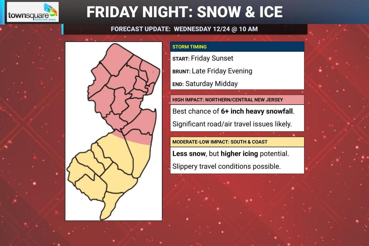
Impacts forecast for Friday night’s snow, as of Wednesday morning. (Dan Zarrow, Townsquare Media)Impacts forecast for Friday night’s snow, as of Wednesday morning. (Dan Zarrow, Townsquare Media)
The snow bullseye of this clipper system — not just in NJ, but for the entire northeastern U.S. — looks like it will end up somewhere between northwestern and central NJ. According to the latest model guidance, that “sweet spot” is most likely to end up right in the middle of the state, from Warren and Morris to Somerset and Middlesex to even Monmouth counties That core of NJ has the best potential of picking up over 6 inches of snow Friday night — that qualifies as heavy snow and a major winter storm.
To the north, especially over the urban center of NE NJ, models have waffled over whether the heaviest snow will visit there.
Just south of that bullseye area, close to the I-195 corridor, I think we are still going to see some healthy snow accumulations. But I have to play the probabilities here — the chance of big snow gets lower and lower the farther south you go.
While I have opted to not draw a specific snowfall accumulation forecast map at this time, you can translate the “red” area of my impacts map as “about 6 inches”. Or call it “4 to 8 inches” if you really want. (I was tempted to go “6 to 10 inches” but that’s very bold for me this early in the forecast life cycle.)
What about potential icing?
Southern New Jersey is even more complicated. You will fall out of the heaviest precipitation bands. And temperatures at all layers may be too warm for straight snow to fall.
The worst case scenario for South Jersey would be for a full-on ice storm, a period of sleet and freezing rain causing a thick glaze of ice. That would not only create hazardous driving conditions, but ice also weighs heavily on trees and power lines causing outages.
I am not ready to fully ring those icy alarm bells yet, as forecast temperatures aloft have swung slightly colder. (Keeping the highest icing potential south of New Jersey.) But let’s be ready for a mix of anything — or everything — across the southern third of the state. Snow accumulation will probably be limited. Or even zero. But I think things still could be slippery and sloppy Friday night into Saturday morning, regardless.
How will travel be affected by the wintry weather?
As you know, it iks all about traction and visibility. Accumulating snow and ice can make for very slippery driving and walking conditions. And as wintry precipitation falls from the sky, it may be difficult to see much beyond your windshield and headlights, especially during heavy snowfall.
That is exactly the kind of adverse weather we are expecting Friday night. Residual wintry impacts will last through at least Saturday morning too, although major roads should be in good shape by the afternoon at the latest.
Air delays and cancellations are almost certain Friday night through much of Saturday. Keep an eye on your flight status. And if given the option to proactively change to an earlier or much later flight, you may want to strongly consider it.
Is this a repeat of the Boxing Day 2010 snow storm?
Absolutely not. You may remember the day-after-Christmas storm from 15 years ago, a major nor’easter that produced blizzard conditions over New Jersey that affected holiday travel for days.
Up to 32 inches of snow fell during that storm.
Needless to say, the Boxing Day 2025 storm will not even come close to that one. Still impactful, but two feet less snow.
How might this forecast change over the next 48+ hours?
For the most part, I think the storm timeline is locked in. This is a Friday evening to Saturday morning event. We may need to adjust the exact times by a couple hours, perhaps. But I don’t see much changing there.
I also think the overall impact level and messaging for this storm is locked in. This one is going to be impactful, even significant, for most of New Jersey. Wintry travel will be a hindrance to many, especially given the timing over the holiday week.
The precipitation type and accumulation forecast, however, remain very tricky. And precarious — any little shift in the heaviest snow band, north or south, could result in big differences of who gets buried in snow and who gets hardly anything. We also have to watch the icing potential in South Jersey very carefully.
The biggest challenge of all here is the Christmas holiday. I am not sacrificing family time to watch the weather. And I know you do not want to be bombarded by weather updates during your festivities either.
So I am going to provide regular, unintrusive updates via social media between now and when the final flakes fly. I am going to write and publish another (brief) weather blog update on Thursday around the early afternoon hours. And then I will issue a final forecast Friday morning, before we hit storm coverage hard both on-air and online throughout the day, throughout the night, and into Saturday morning too.
5 DAY FORECAST: New Jersey Weather Center
Christmas snow – When it’s happened, and the 2025 odds for NJ
Fun weather facts from Chief Meteorologist Dan Zarrow, using data from the New Brunswick weather station. The trend for this year’s Christmas is also included.
Gallery Credit: Mike Brant
Dan Zarrow is Chief Meteorologist for Townsquare Media New Jersey. Follow him on Facebook for the latest forecast and realtime weather updates.
Some of the best Christmas house decorations in New Jersey
Just some of the submissions we received for the Light Up New Jersey contest in 2025. The winner will be announced Dec. 23.
Gallery Credit: New Jersey 101.5