- Posidonia oceanica is a Mediterranean seagrass whose meadows act as a carbon sink, a coastal protector and a nursery for marine life.
- This ecosystem is under severe threat from human activities, including illegal trawling, pollution and boat anchoring, resulting in significant degradation and loss of biodiversity.
- Italy is employing sophisticated sensors to create an unprecedentedly detailed and comprehensive map of its entire coastline, including its Posidonia meadows, in an effort to improve management and conservation of its marine habitats.
- While large-scale mapping provides the blueprint, targeted protection and restoration efforts demonstrate that it’s possible to reverse the damage and bring life back to the sea.
See All Key Ideas
ROME and GENOA, Italy — In the urban waters off Naples, shoals of bream, wrasses, as well as crustaceans, mollusks and bryozoans are returning after decades of absence to Gaiola Submerged Park Marine Protected Area.
“This MPA has turned into a significant repopulation zone for the surrounding coast of Posillipo,” Maurizio Simeone, a marine biologist and the MPA’s director, told Mongabay. “The fishermen themselves tell us this.”
Farther west, in the archipelago of La Maddalena off the northern tip of Sardinia, the scene is starkly different. Boat tour operators have seen the crystalline waters turning murkier and iconic species such as seahorses becoming rarer sightings.
The difference between the two seascapes lies in the health of a single, vital ecosystem type: Posidonia oceanica seagrass beds. At Gaiola, decades of strict protection and active restoration experiments have allowed the meadows to recover; at La Maddalena, the meadows have been damaged by intense, uncontrolled boat anchoring. Here, too, researchers have implemented bans on anchoring and begun planting new cuttings. The plant itself has “a very slow growth,” Marina Pulcini, a marine biologist at the Italian Institute for Environmental Protection and Research (ISPRA), told Mongabay, and reestablishing dense meadows may take a decade. But the high survival rate (more than 90%) of the initial transplants offers hope that the ecosystem can begin to revitalize now that pressures are reduced.
For decades, Italy’s efforts to conserve its seagrass meadows have been hampered by a lack of information, with the last push to map seagrass beds dating back 20 to 30 years. Now, from the depths of the Adriatic to the shores of Sicily, the country has embarked on an ambitious, multimillion-euro initiative to create the first complete, high-resolution map of its coastal habitats. Using a fleet of ships, aircraft and autonomous vehicles, the Italian Marine Ecosystem Restoration (MER) coastal mapping project aims to monitor and protect the country’s Posidonia meadows in a bid to reach the global “30×30” target of protecting 30% of the world’s oceans by 2030.
More than just seagrass
P. oceanica is a flowering marine plant endemic to the Mediterranean, found nowhere else on Earth. While seagrass meadows composed of different species are common worldwide, this species forms vast, ecologically complex underwater ecosystems unique to this region. These ecosystems shelter juvenile fish and support commercially important fisheries, hosting an estimated 20% of all Mediterranean marine species. The plants’ dense root systems, known as mattes, stabilize the seabed and protect coastlines from erosion, while their canopy absorbs the energy of waves. They also act as a carbon sink. P. oceanica alone has sequestered between 11% and 42% of the region’s carbon dioxide emissions since the onset of the Industrial Revolution, according to one estimate. It sequesters carbon up to 35 times faster than rainforests and locks it away in the sediment for thousands of years.
Yet this vital habitat is disappearing. In the Mediterranean, some areas regressed by as much as 34% over the last half-century, according to a 2015 paper that provides the most recent estimate covering the whole region.
Posidonia oceanica restoration site at La Maddalena. Here researchers use star-shaped modules made of bioplastic to anchor the Posidonia cuttings into the seabed. Image courtesy of Marina Pulcini.
“There has been a very, very significant degradation,” Pulcini said. The primary culprits are human activities, including coastal development, pollution, uncontrolled boat anchoring and illegal bottom trawling. Pulcini said these latter two activities in particular inflict “wounds, channels, furrows, and drags that tear up the otherwise dense forest of the meadow.”
The MER coastal mapping project will ultimately allow scientists to evaluate the current conservation status of Posidonia meadows, identify the most vulnerable areas, and monitor the effectiveness of protection and restoration actions, said Chiara Robello, a Ph.D. candidate in marine ecosystem science at the University of Genoa, who isn’t involved in the project. “An updated, high-resolution cartography of Posidonia oceanica meadows is fundamentally important. The currently available maps are old and often incomplete: many regions lack recent data on the extent of the meadows or their state of health.”
A high-tech alliance to see beneath the waves
The MER project is a massive 400 million euro ($465 million) marine restoration effort funded by an EU stimulus package called NextGenerationEU through Italy’s National Recovery and Resilience Plan (PNRR) and led by ISPRA. The coastal mapping project, a component of MER allocated nearly one-tenth of its budget, unites academic institutions, the Italian Navy Hydrographic Institute and technology specialists such as Dutch geodata multinational Fugro-CGR. It involves multisensor, multilevel and multiscale surveys along the entire 7,900-kilometer (nearly 5,000-mile) Italian coastline, down to a depth of 50 meters (about 160 feet) in the sea and 800 m (about 2,600 ft) inland. The aim is to create an interactive digital twin of the coast. This virtual model will be the first detailed, updated map of all marine habitats, which will allow officials to identify pressures, assess coastal vulnerability to erosion and flooding, and plan future restoration efforts.
The project uses a constellation of sensors — beaming out various frequencies of light and sound waves, and measuring the reflected signal — to build a seamless 3D map of the coast. The process begins with very high-resolution multispectral satellites, like the Maxar WorldView 2 and 3 series, which analyze different light frequencies to create a preliminary map of water depth and seabed composition. Different materials on the Earth’s surface reflect and absorb these different frequencies in unique ways. For example, the spectral signature of a dense, healthy Posidonia meadow is distinct from that of a sandy bottom or a rocky outcrop.
Synoptic image of the technology from Dutch company Fugro-CGR that the MER coastal mapping project deploys. Image courtesy of Fugro.
Based on this initial map, three aircraft equipped with lidar technology — beaming out laser rays — take to the skies. One plane maps the terrestrial coastal strip, providing data on urbanization and land-based activities that can impact the marine environment, according to Francesco Rende, a marine scientist at ISPRA who coordinates the coastal mapping project.
The other two planes use a powerful laser, capable of penetrating 50 m below the sea surface, to map the seabed. “This is an important technological advancement,” Rende said, as it allows for rapid and accurate mapping of the seabed from the air, a significant leap from older, more limited surveying methods.
In deeper or more turbid waters where the laser can’t penetrate, ships equipped with multibeam echosounder systems (MBES) take over. Instead of light waves, this sends out sonar pulses — sound waves — to create a detailed 3D map of the underwater terrain that can indicate the vigor of any seagrass beds. “We can distinguish a hard, rocky bottom from a soft, muddy one, or identify the texture of a Posidonia meadow,” said Daniela Taliana, the country manager for Fugro Italy.
All this remote-sensing data must then be validated. This is the job of an uncrewed, torpedo-shaped autonomous underwater vehicle (AUV) outfitted with a highly advanced hyperspectral camera that captures detailed video across a vast range of light frequencies, which allows researchers to visually confirm the presence and health of the Posidonia meadows.
This rich set of data is fed into machine-learning algorithms that analyze and cross-reference the different layers of information to create the final product: a digital copy of the entire Italian coast.
In practice, the algorithm looks at a single point on the seabed and compares the data from every sensor. If the satellite’s spectral signature, the multibeam’s backscatter, the lidar’s bathymetry and the AUV’s video are consistent, the AI can automatically classify that point, for example, as a “Posidonia meadow in good health.” This automated analysis is what makes it possible to process the immense volume of data from 7,900 km of coastline and build the final, detailed map. If the data from the different sensors are inconsistent for a particular point, the AI flags the area, and human experts make the final interpretation and classification.
Mapping process for seafloor classification in Milazzo, Sicily. A) Aerial RGB photo; B) high-resolution multibeam and LiDAR bathymetry; C) LiDAR intensity (preliminary not processed) and MBES backscatter; D) preliminary seafloor classification results deriving from their integrated analysis.
A new baseline
The MER coastal mapping project has a very tight timeline. It began in July 2024 and is scheduled to be completed by June 2026. Acquisition of satellite data for the entire coastline is complete, and topographic lidar acquisition should be done by the end of this year. The researchers say they hope to acquire the MBES data and AUV video by mid-2026; in the meantime, they continue to process data as it comes in. “The final objective is to have a new baseline,” Taliana said. “What we are doing now is providing a tool to the researchers to be able to make their assessments for the protection of this environment.”
This new, high-resolution baseline is already challenging long-held assumptions. The most significant discovery is that Italy’s Posidonia meadows are “much more extensive and live in much deeper waters than was known,” Rende said, pointing to the north of Sardinia on his screen. “That was a great surprise.” The old cartography of that exact spot showed a thin strip of seagrass close to shore, but the new survey revealed that the meadow extends far out from shore and into much deeper waters than previously thought possible.
The high-resolution maps are also a powerful tool for law enforcement. Rende said when the researchers spot signs of illegal bottom trawling in Posidonia meadows, they alert maritime authorities.
The maps will also guide MPA management and future conservation. “For areas already mapped in the past, this new cartography will help compare data over time and better understand the dynamics of change in these ecosystems,” said Robello, the doctoral researcher. “This is essential for planning more effective protection interventions, preventing impacts, and contributing concretely to achieving the conservation objectives of the 30×30 target.”
Italy is the first country to attempt such a comprehensive national mapping of its coast, and the team is realistic about the challenges. “The fact that different technologies are combined represents enormous added value, ensuring a wholeness and accuracy of data never achieved before,” Robello said.
A research vessel gathers bathymetric data off the coast of Panarea Island, Sicily. Image courtesy of Fugro.
But the project is a massive undertaking, and its reliance on expensive technology makes it difficult to replicate wholesale. “Other parts of the world might not need to replicate our entire, complex approach,” Rende said. “Using [just] some of the layers of investigations or some of the technologies we are using might offer enough insights.”
With its extensive coastline, the 14th-longest of any country, Italy can contribute much to global ocean protection, but “you can’t protect what you don’t know,” said Taliana. The Mediterranean, she added, often acts as a global laboratory where climate impacts are concentrated and accelerated. By creating this detailed benchmark, Italy is generating vital knowledge needed to understand — and perhaps get ahead of — the challenges facing marine ecosystems worldwide.
It’s not just about meeting the acreage goals of the approaching 30×30 deadline; it’s about understanding where protection matters most to bring life back to the sea. As Posidonia meadows heal, marine species return in abundance, as is happening at Naples’s Gaiola MPA, said Simeone, the protected area’s director, who isn’t involved in the MER project.
“If you can protect the right area, the benefits are seen almost instantaneously.”
Divers work on a Posidonia oceanica restoration site at the Gaiola Submerged Park Marine Protected Area near Naples. The bare seabed before the restoration intervention (left); the transplanted Posidonia cuttings beginning to establish a new meadow after the intervention (right). Image courtesy of Maurizio Simeone.
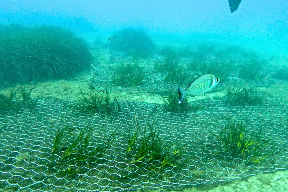
Banner image: Posidonia oceanica restoration site in Liguria. As cuttings beginning to establish a new meadow, fish return. Image courtesy of Chiara Robello.
This story was produced with the support of the Earth Journalism Network.
Seagrass mapping helps identify restoration potential
Citations:
Pergent, G., Bazairi, H., Bianchi, C. N., Boudouresque, C. F., Buia, M. C., Calvo, S., … Verlaque, M. (2014). Climate change and Mediterranean seagrass meadows: A synopsis for environmental managers. Mediterranean Marine Science, 15(2), 462-473. doi:10.12681/mms.621
Telesca, L., Belluscio, A., Criscoli, A., Ardizzone, G., Apostolaki, E. T., Fraschetti, S., … Salomidi, M. (2015). Seagrass meadows (Posidonia oceanica) distribution and trajectories of change. Scientific Reports, 5(1). doi:10.1038/srep12505
FEEDBACK: Use this form to send a message to the editor of this post. If you want to post a public comment, you can do that at the bottom of the page.