Hurricane Melissa made a second landfall Wednesday in eastern Cuba near the city of Chivirico as a Category 3 storm, a day after barreling into Jamaica as the strongest hurricane to hit there since 1851.
The storm was expected to create storm surge of up to 12 feet and drop up to 20 inches in Cuba.
Over the Southeast Bahamas, total rainfall of 5 to 10 inches is expected into Wednesday.
Melissa will likely be weakened by wind shear, but should still be a hurricane by the time it reaches Bermuda late Thursday or early Friday. A hurricane watch is in place for the island.
The U.S east coast should expect, large swells and tumultuous marine conditions later in the week, as effects from Melissa combine with a storm traveling across the U.S.
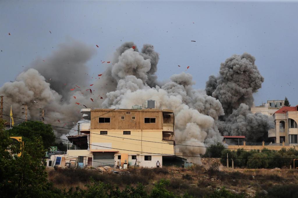
Throughout Tuesday, heavy floodwaters swept across southwestern Jamaica, winds tore roofs off buildings and boulders tumbled into roads. About 1 p.m. Tuesday, Melissa’s eye made its first landfall at New Hope, Jamaica, 75 miles west of Kingston, with maximum sustained winds of 185 mph, tied for the strongest Atlantic hurricane landfall in history.
As of 5 a.m. Wednesday, Melissa was 60 miles west of Guantanamo, Cuba, and about 230 miles south of the central Bahamas. Wind speeds had dropped to 125 mph as it moved northeast at 17 mph.
Pictures: Category 5 Hurricane Melissa pummels Jamaica
Desmond McKenzie, deputy chairman of Jamaica’s Disaster Risk Management Council, said extensive damage was reported in the southwestern parish of St. Elizabeth, which he said “is underwater.”
Hurricane Melissa’s position as of 5 a.m. Wednesday, Oct. 289 2025. (National Hurricane Center/Courtesy)
The storm’s track leads to the Bahamas, where it should cross through by Wednesday afternoon.
Officials in Jamaica have said they hope to reopen the island’s airports by Thursday.
U.N. agencies and dozens of nonprofits had food, medicine and other essential supplies positioned as they awaited a distribution rush after the storm.
This footage from inside the eye of Category 5 Hurricane Melissa might be the most jaw-dropping video ever captured of a hurricane’s eye, showcasing the infamous “stadium effect.” pic.twitter.com/AEhj2g2Ban
— Colin McCarthy (@US_Stormwatch) October 27, 2025
Experts say Hurricane Melissa’s 185 mph winds and 892 millibars of central pressure on landfall tied two different records for the strongest Atlantic storm upon hitting land.
The pressure measurement — the key one meteorologists use — ties with 1935’s Labor Day hurricane in Florida.
And the wind speed ties with that 1935 hurricane and 2019’s Hurricane Dorian, which made landfall on Abaco Island in The Bahamas. That’s according to hurricane scientists Philip Klotzbach of Colorado State University and Brian McNoldy of the University of Miami.
“It’s been a remarkable just a beast of a storm,” Klotzbach said.
People walk along a road during the passing of Hurricane Melissa in Rocky Point, Jamaica, Tuesday, Oct. 28, 2025. (AP Photo/Matias Delacroix)
Melissa somehow shook off at least three different meteorological conditions that normally weaken major hurricanes and was still gaining power as it hit, scientists said, a bit amazed.
And while more storms these days are undergoing rapid intensification — gaining 35 mph in wind speed over 24 hours — Melissa did a lot more than that. It achieved what’s called extreme rapid intensification — gaining at least 58 mph over 24 hours. In fact, Melissa turbocharged by about 70 mph during a 24-hour period last week, and had an unusual second round of rapid intensification that spun it up to 175 mph, scientists said.
Melissa rapidly intensified during five six-hour periods as it hit the extreme rapid intensification level, McNoldy said. And then it jumped another 35 mph and “that’s extraordinary,” McNoldy said.
“Overheated deep-hot Caribbean waters are a big reason for this history-making event,” WFLA-TV meteorologist Jeff Berardelli wrote on social media platform X. The region had sea surface temperatures more than 2 degrees F warmer than the 20th century norms. Hotter water fuels rapid intensification of storms.
The so-called “spaghetti models” on Wednesday show the potential decline in Hurricane Melissa’s intensity. (polarwx/Courtesy)
A storm of Category 4 or higher has not made landfall in Jamaica in 174 years of record-keeping.
Hurricane Gilbert was a Category 3 storm when it hit the island in 1988.
Hurricanes Ivan and Beryl were both Category 4, but they did not make landfall on the island, said Evan Thompson, principal director at Jamaica’s meteorological service.
The storm has been blamed for at least seven deaths so far in the Caribbean — three in Jamaica, three in Haiti and one in the Dominican Republic.
Forecast computer tracks, known as “spaghetti models,” on Wednesday show Hurricane Melissa making an eventual pivot northeast out to sea. (polarwx.com/courtesy)
Melissa is the 13th named storm of the 2025 Atlantic hurricane season.
Four hurricanes have formed so far. Of the 13 named Atlantic storms, only Tropical Storm Chantal has made a U.S. landfall.
Hurricane season runs through Nov. 30.